80s For Highs To End September And Begin October - Record Highs Possible Sunday

A very warm Fall weekend is ahead - in fact, Sunday will see highs near a record in the metro. More storms are possible across the state Friday Night into early Saturday, and the metro has a Saturday evening chance as well. - D.J. Kayser

September 30, 2023 at 12:00AM
(The Minnesota Star Tribune)

Heavy Friday Morning Rain - Severe Threat Friday Evening/Night

(The Minnesota Star Tribune)

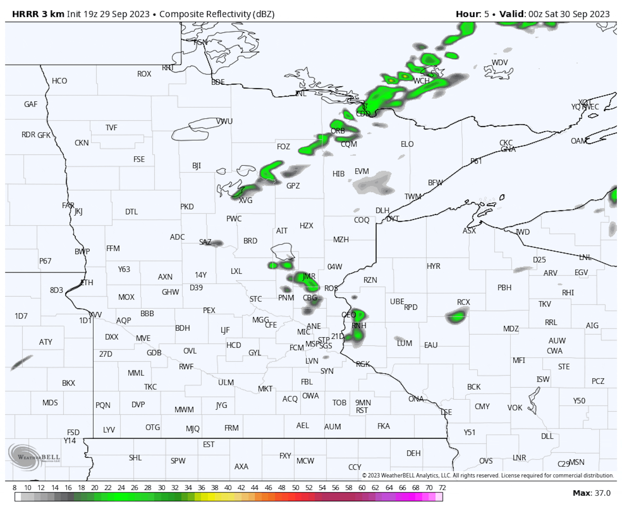
Several rounds of showers and thunderstorms impacted the metro during the morning commute on Friday, bringing another 0.5-2" (or more) of rain across the region. My personal rain gauge in the northwest metro picked up just over 2.5" of rain from these repeated, training storms - with plenty of thunder to wake me up out of bed.

(The Minnesota Star Tribune)

Forecast loop from 7 PM Friday to 7 AM Saturday.

As we head into Friday evening and the overnight hours, another round of showers and storms - some of which could be strong - is expected to pop from southwestern Minnesota to the North Shore. This will also bring another round of heavy rain with it, and Flood Watches are in place around the Twin Ports for the potential of 2"+ which could lead to flooding (especially on top of the heavier flooding rains earlier this week).

(The Minnesota Star Tribune)

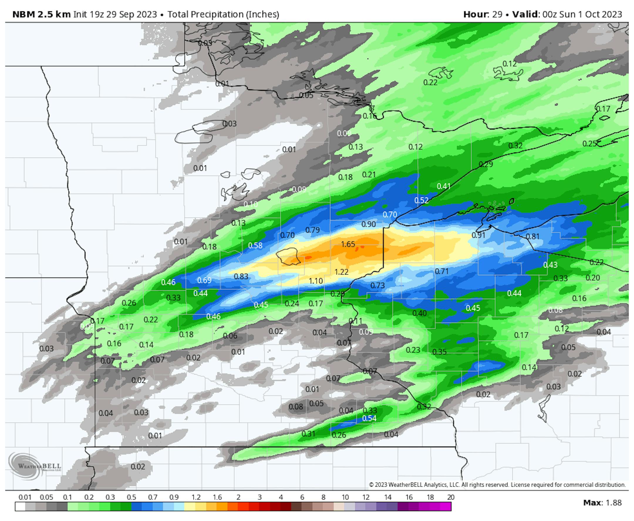
The Flood Watch Friday Night is in place for areas like Hinckley, Duluth, Two Harbors, and Silver Bay, where the heaviest rain could fall.

(The Minnesota Star Tribune)

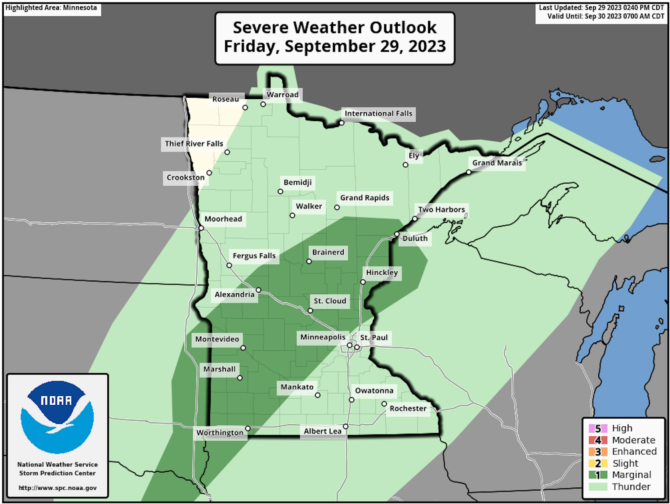
And a few of those storms Friday evening and overnight could be on the strong side, with hail and wind the main threats, from Sioux Falls to Duluth.

_______________________________________________

Fall Color Update

(The Minnesota Star Tribune)

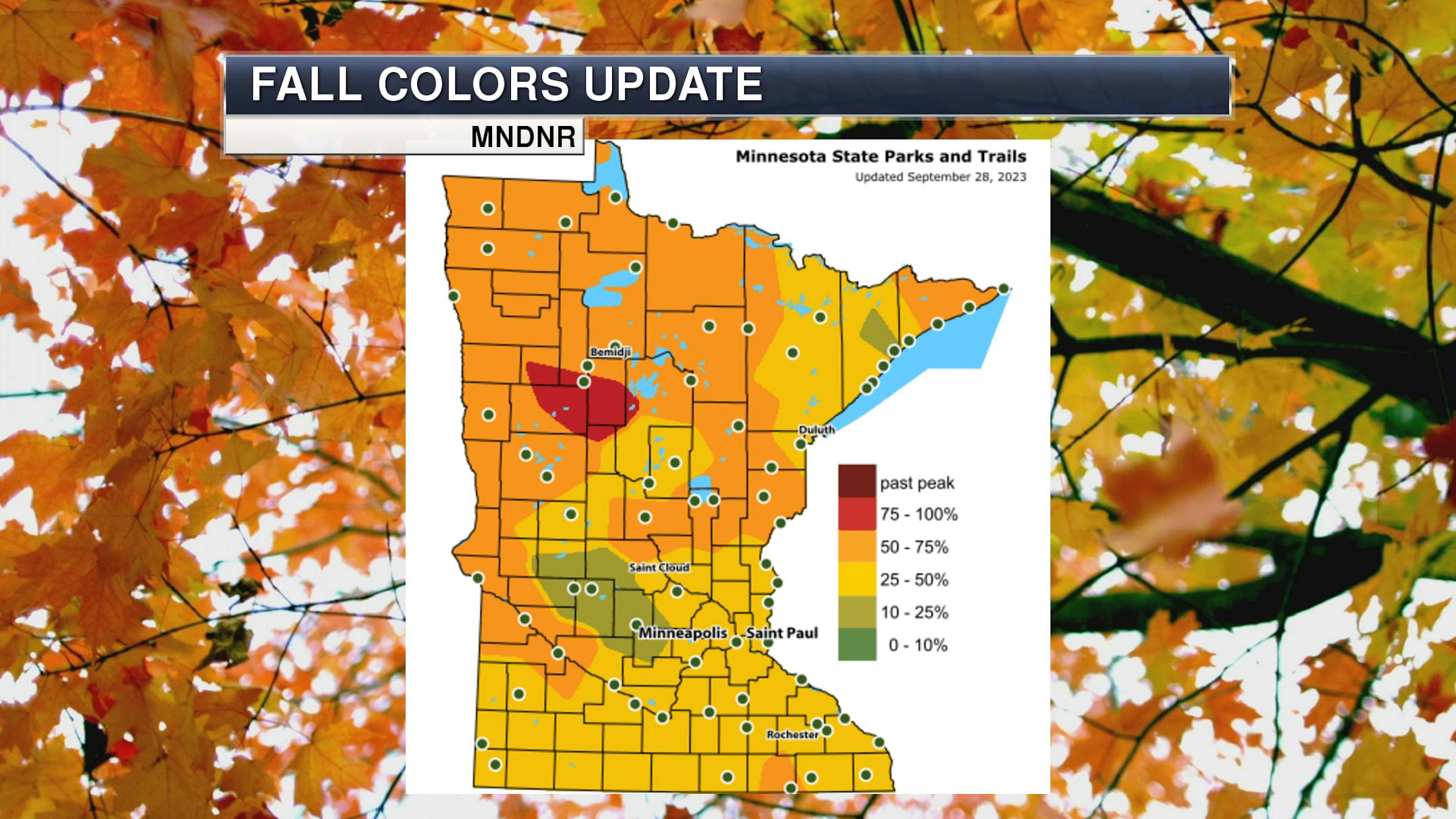
We continue to see a good portion of the state between 25-75% fall color according to the latest update from the Minnesota DNR Fall Color Finder. However, Itasca State Park is the first one statewide to pop into the 75-100% color category, reporting Thursday that "Colors are moving towards the peak as paper birch, aspen, and oaks begin to add color. Big-tooth aspens are starting to add a bright red-orange color in the canopy. Trembling aspen are beginning to turn bright yellow-gold. The deep gold of paper birch is appearing. More red oaks are turning deep red-brown to bright red-orange. Bur oaks are adding a soft camel tan-brown color. Ironwoods are turning a deep gold. Pops of deep red, bright orange, and yellow-gold are mixed throughout the forest as red and sugar maples peak. The khaki-yellow color in the balsam poplar leaves can still be seen. American basswoods are a soft butter-yellow color as they now peak. Black ash is moving past peak. Two- and 3-year-old needles are turning gold and shedding from white pine. The fourth-year red pine needles turn reddish-brown before dropping."

_______________________________________________

Drought Improvements Due To Recent Heavier Rains

(The Minnesota Star Tribune)

Over the past week, we saw heavy rainfall across portions of eastern Minnesota - with some areas seeing 7-day rain amounts that were up to 5" above average.

(The Minnesota Star Tribune)

These heavier rains led to a lot of drought improvement across the state week-to-week, with no Exceptional Drought (D4/4) in place and D3 Extreme Drought down to 8.03% from the 26.07% it was at in last week's update. However, the entire state continues to be considered at least abnormally dry.

(The Minnesota Star Tribune)

As we look at the drought map week to week, we can see a lot of Minnesota saw at least some improvement in the drought. The good news is that there was no area that saw the drought worsen - even in areas of southwestern Minnesota which saw below-average precipitation over the past week.

_______________________________________________

Isolated Storm Chance Remains Saturday

(The Minnesota Star Tribune)

We will continue to watch the potential of a few showers or storms in the metro - mainly in the early morning hours - as we head into Saturday. A few storms can't be ruled out in the evening either. Otherwise, partly sunny conditions are expected with highs climbing to the low 80s for the last day of September.

(The Minnesota Star Tribune)

Looking statewide, the best chance of a few showers or storms lingering on Saturday (mainly during the morning hours) will be in the eastern parts of the state into western Wisconsin - though a few could reform by the evening hours. Highs range from the 60s up north to the 80s in southern Minnesota.

_______________________________________________

Record Highs Possible Sunday

(The Minnesota Star Tribune)

It'll be even warmer on Sunday for the first day of October - not exactly feeling like pumpkin spice weather (unless you put some ice in it!). The record for Sunday in the metro is 87F in 1897 - and we could be very close to that under mainly sunny skies. St. Cloud and Park Rapids could also approach their records for the day. Strong southerly winds of 10-20 mph, gusting to 25-30 mph, will help pump the heat into southern Minnesota on Sunday. Some scattered storms will be possible in northern Minnesota.

_______________________________________________

Cooler Weather Finally On The Way?

(The Minnesota Star Tribune)

Warm weather in the 80s will continue into early next week, but we could finally be breaking some of this heat by the middle of the week. More fall-like feeling weather with highs in the 50s and 60s are expected from Wednesday through at least the first weekend of October. We'll have to see what happens after that - but maybe, just maybe, it'll finally feel like fall for an extended period of time.

_______________________________________________

Near Record Heat Sunday and Monday
By Paul Douglas

"You can please some of the people all of the time, you can please all of the people some of the time, but you can't please all of the people all of the time" wrote poet John Lydgate, later used by President Abraham Lincoln. Yup.

With the weather what works for farmers will probably leave golfers and boaters unhappy. There is no such thing as "perfect weather". I'm happy to report this forecast has drought, floods, sweaty heat and sweatshirts, all in the same 7-Day. What a bargain!

We've gone from extreme to severe drought in the metro, and a few T-storms this morning may greet us before the sun peeks out later.

Sticky dew points will linger into Tuesday with near-record heat Sunday and Monday (mid to upper 80s). The heat index Sunday afternoon may be in the 90s. Be careful out there. I'll be the guy pushing the ice cream cart in the Twin Cities Marathon.

Midweek rain ushers much cooler air into Minnesota late next week. Next weekend highs hold in the 40s and 50s. You know, like typical autumn weather?_______________________________________________

Paul's Extended Twin Cities Forecast

SATURDAY: Early T-storm. Some PM sun. Wake up 66. High 82. Chance of precipitation 70%. Wind SE 8-13 mph.

SUNDAY: Sunny, near-record heat. Wake up 68. High 86. Chance of precipitation 10%. Wind S 10-20 mph.

MONDAY: More July than October. Still sunny. Wake up 68. High 85. Chance of precipitation 10%. Wind S 10-20 mph.

TUESDAY: Sweaty sunshine, T-storms late. Wake up 67. High 82. Chance of precipitation 60%. Wind S 10-20 mph.

WEDNESDAY: Showers and T-storms, windy. Wake up 68. High 74. Chance of precipitation 70%. Wind S 15-30 mph.

THURSDAY: Breezy and cooler with some sunshine. Wake up 70. High 64. Chance of precipitation 20%. Wind W 15-30 mph.

FRIDAY: Feels like fall, passing shower? Wake up 51. High 57. Chance of precipitation 30%. Wind NW 15-35 mph.

_______________________________________________

Minneapolis Weather Almanac And Sun Data
September 30th

(The Minnesota Star Tribune)

*Length Of Day: 11 hours, 45 minutes, and 59 seconds
*Daylight LOST Since Yesterday: 3 minutes and 6 seconds

*When Do We Drop Below 11 Hours Of Sunlight? October 15th (10 hours, 59 minutes, 51 seconds)
*When Are Sunrises At/After 7:30 AM? October 17th (7:31 AM)
*When Are Sunsets At/Before 6:30 PM? October 14th (6:30 PM)
_______________________________________________

This Day in Weather History
September 30th

1995: Lightning starts a house on fire in Washington County.

1985: 4 inches of snow falls in Ely, with just a trace in the Twin Cities.

_______________________________________________

National Weather Forecast

(The Minnesota Star Tribune)

On Saturday, we'll continue to track showers and an isolated storm in the New York City area as the area of low pressure that brought flooding rains to NYC on Friday is finally moving away. Storms will also impact portions of the Great Lakes, Florida, and southern Texas. Messy weather is expected in the western United States, with showers, storms, and even some snow.

(The Minnesota Star Tribune)

Heavy rain will continue to impact Florida into the weekend, with rainfall amounts of 3"+ possible. Meanwhile, the 3-6"+ in the New York City area mainly fell on Saturday, but lingering showers and thunderstorms will still remain on Saturday. Looking at the snow department, several inches of snow could fall in some of the mountain ranges in the western United States.

_______________________________________________

Minnesota utilities spending $130M to improve wind energy transmission

More from the Star Tribune: "A group of power line operators is planning to spend $130 million on several shorter-term fixes to the transmission congestion plaguing southwestern Minnesota wind farms. The grid can't handle all the wind farms that have sprouted in recent years, leading in 2022 to a large amount of "curtailment" — the temporary shutdown of wind turbines. The issue has gotten worse this year, a representative from a major wind farm operator told state utility regulators recently. "2023 has been the worst year we have seen so far for congestion in southwestern Minnesota, and it has spread to other parts of the state," Adam Sokolski, regulatory and legislative affairs director for EDF Renewables, said at a Minnesota Public Utilities Commission (PUC) meeting last week. The turbine shutdowns have led to "dramatic drops" in wind power, Sokolski said. "We are sprinting towards a brick wall, and we may have already hit it in southwestern Minnesota.""

Canada's "hellish" wildfire season defies the calendar

More from Axios: "Canada's wildfire season, already the worst on record, went "completely off the rails" during the past week, scientists tell Axios. The big picture: Enough land area burned in the past week to make the seven-day-period comparable to nearly an entire typical fire season across Canada, according to Merritt Turetsky of the University of Colorado. While five provinces and territories, stretching from Nova Scotia to the Northwest Territories, saw record amounts of land burned this season, western Canada has been hit the hardest, she said in an interview. "Things have just continued to play out in kind of a hellish way in western Canada," she said. During the past few days, smoke from wildfires in British Columbia and the Northwest Territories has tinted the skies over Greenland and northern Europe. These fires are burning at a time of year when Canada's fire activity tends to be on a sharp decline."

The US power grid quietly survived its most brutal summer yet

More from Vox: "With little acknowledgment and no applause, the power grid across the continental United States this summer quietly pulled off what may have been its most impressive feat ever. On July 27, the US grid served nearly 15 million megawatt-hours of electricity across the lower 48 states, about 1.6 times the electricity produced by every nuclear power plant in the world on a given day. It kept lights, fans, and air conditioners running in every home, office, factory, school, hospital, and store on one of the hottest days ever. For comparison, the average daily electricity use in 2022 across the whole country was roughly 11 million MWh. At 6 pm ET, US energy demand reached an all-time high hourly peak of 741,815 MWh. It's even more remarkable when you consider the context: July 27 was just the Mount Everest in a month of Himalayan demand peaks. July 2023 was the hottest month on the planet since at least 1880, possibly the hottest in 100,000 years. The US, being a country on Earth, burst through numerous temperature records. In Death Valley, California, temperatures reached 127.7 degrees Fahrenheit."

_______________________________________________

Follow me on:

Thanks for checking in and have a great day!

- D.J. Kayser

(The Minnesota Star Tribune)

about the writer

D.J. Kayser

See More