Chilly Sunday Start

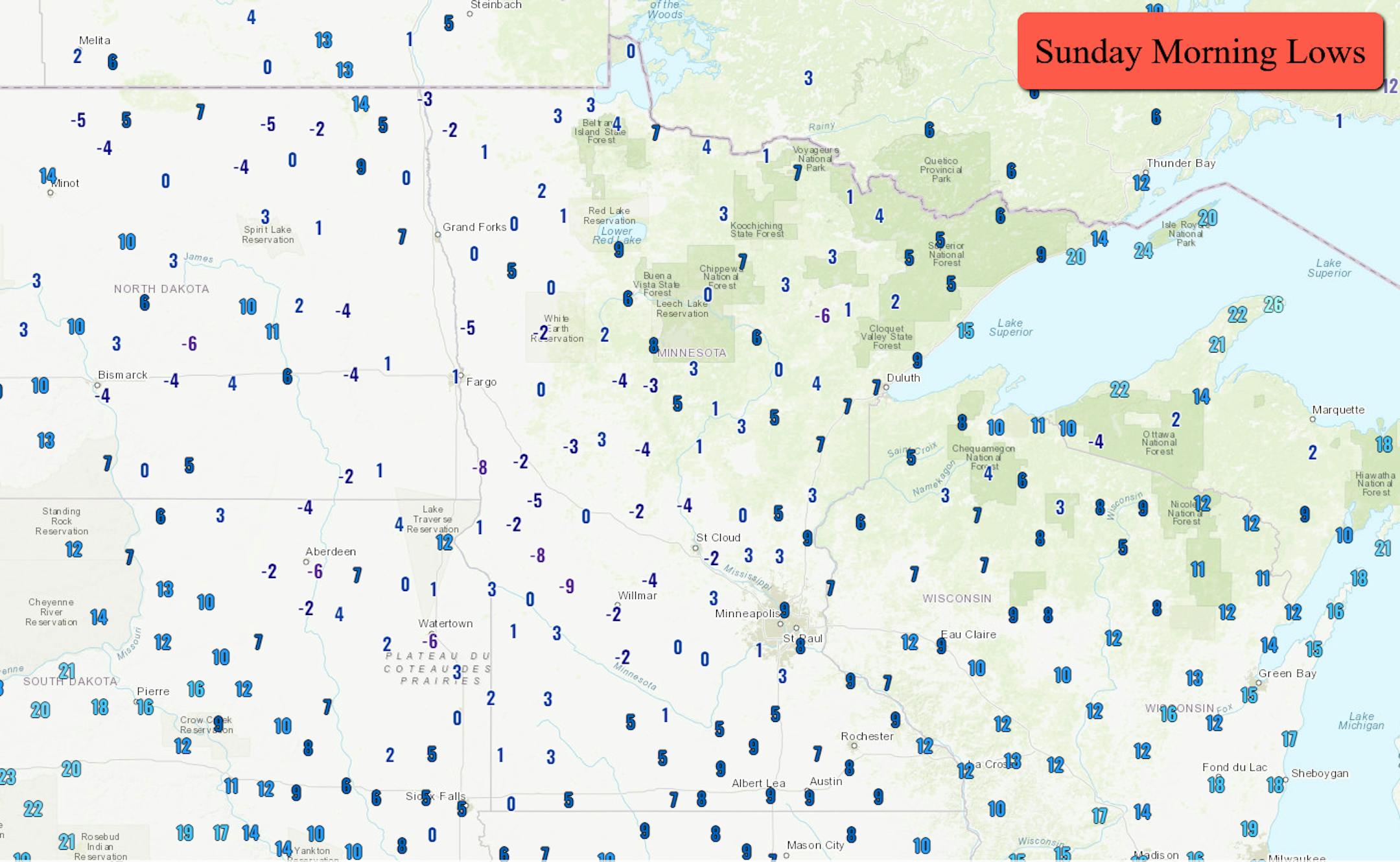
Could Sunday have been one of the last cold mornings for the region? Temperatures across most of the state dipped into the single digits above or below zero. The coldest airport temperatures reported were -9F at Benson, -8F in Morris, and -5F in both Hibbing and Elbow Lake. The low at MSP was +7F - nowhere near the record low of -15F in 1875.

_______________________________________________

Cloudy For The Start Of Spring

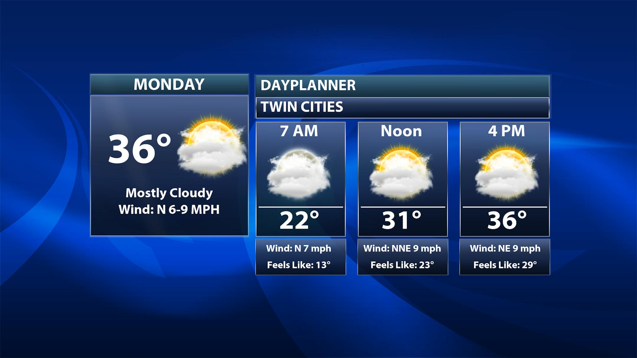
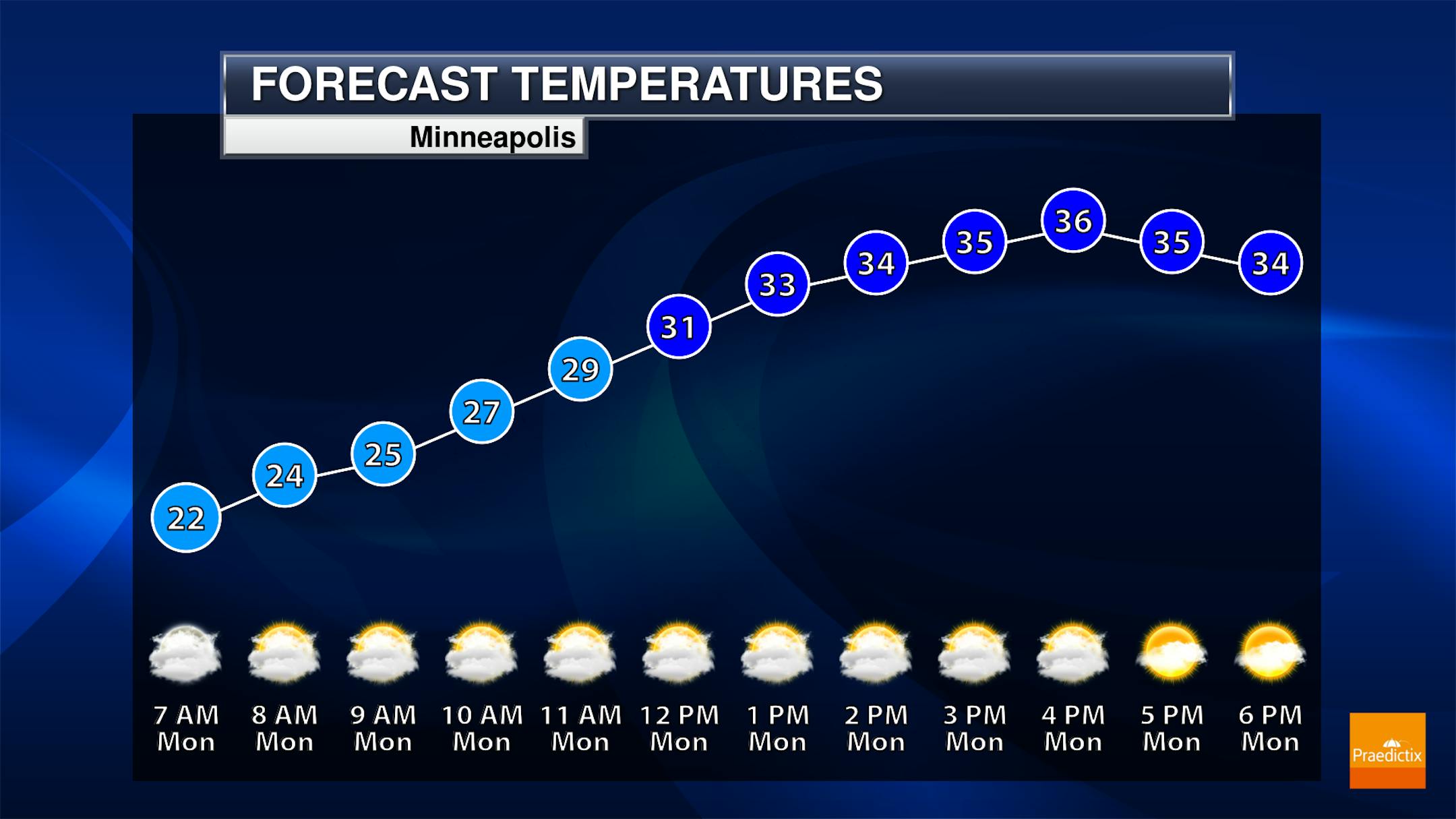
Happy First Day Of Spring! Spring officially begins at 4:24 PM Monday afternoon - so if you're reading this in the morning hours you're still technically in "winter"! It'll be a mainly cloudy day here in the metro with temperatures as you head out to work or the bus stop in the low 20s, climbing to the mid-30s for highs.

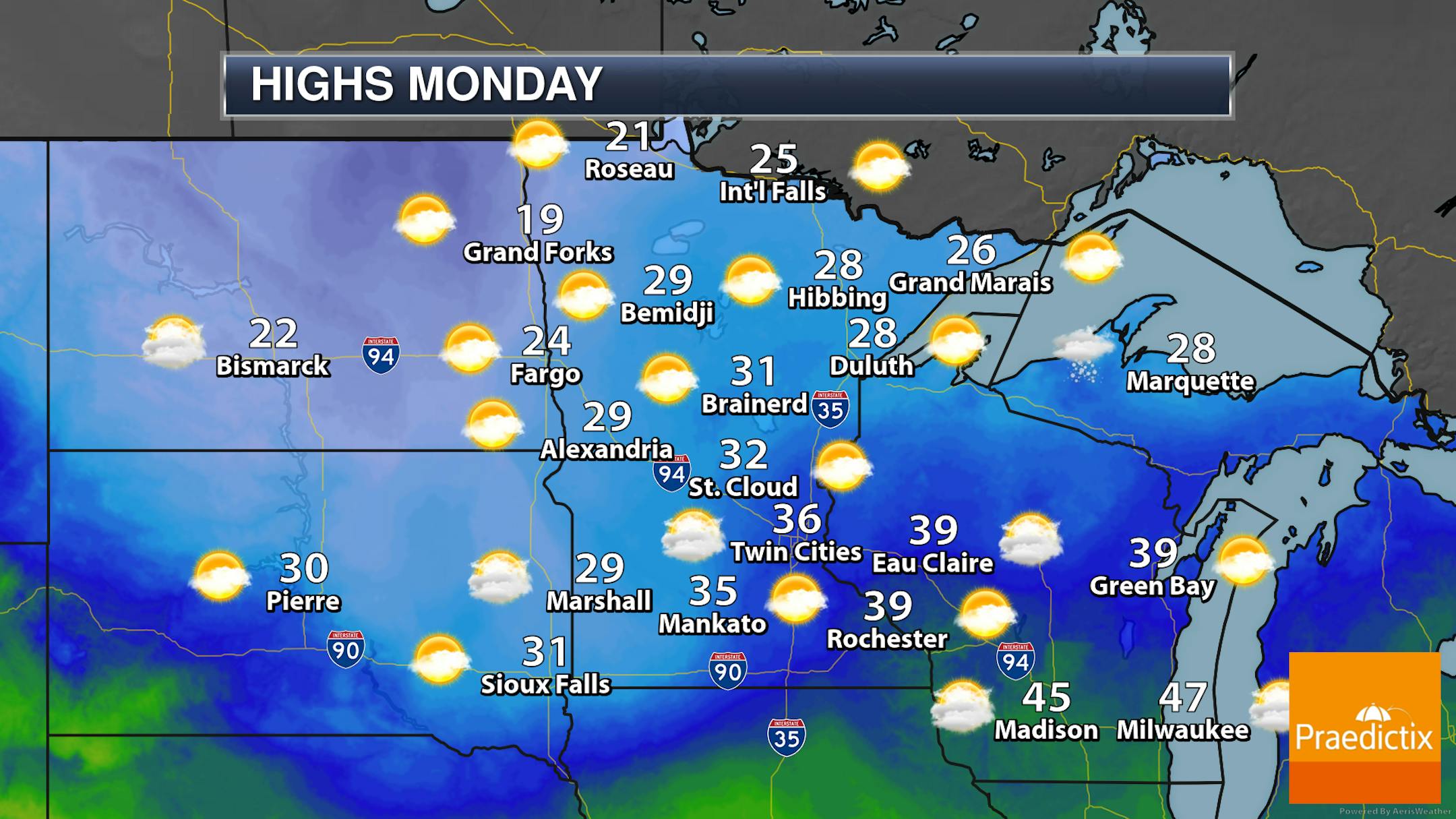
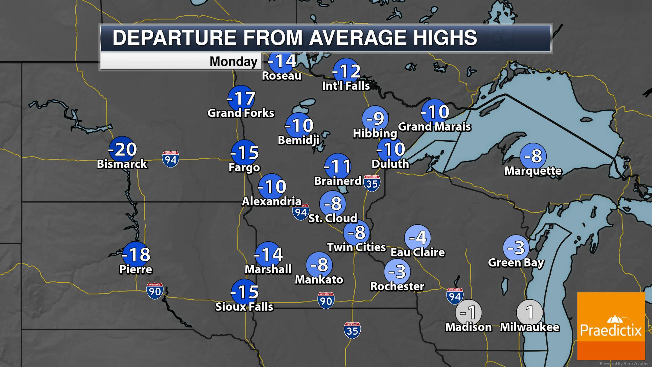
Cloudier skies will reign across the state on Monday - though there will be peeks of the sun at times. In fact, parts of northern Minnesota could see mainly sunny skies into the afternoon hours. Highs remain fairly below average - only in the 20s and 30s.

_______________________________________________

Several 40F Highs Possible This Week

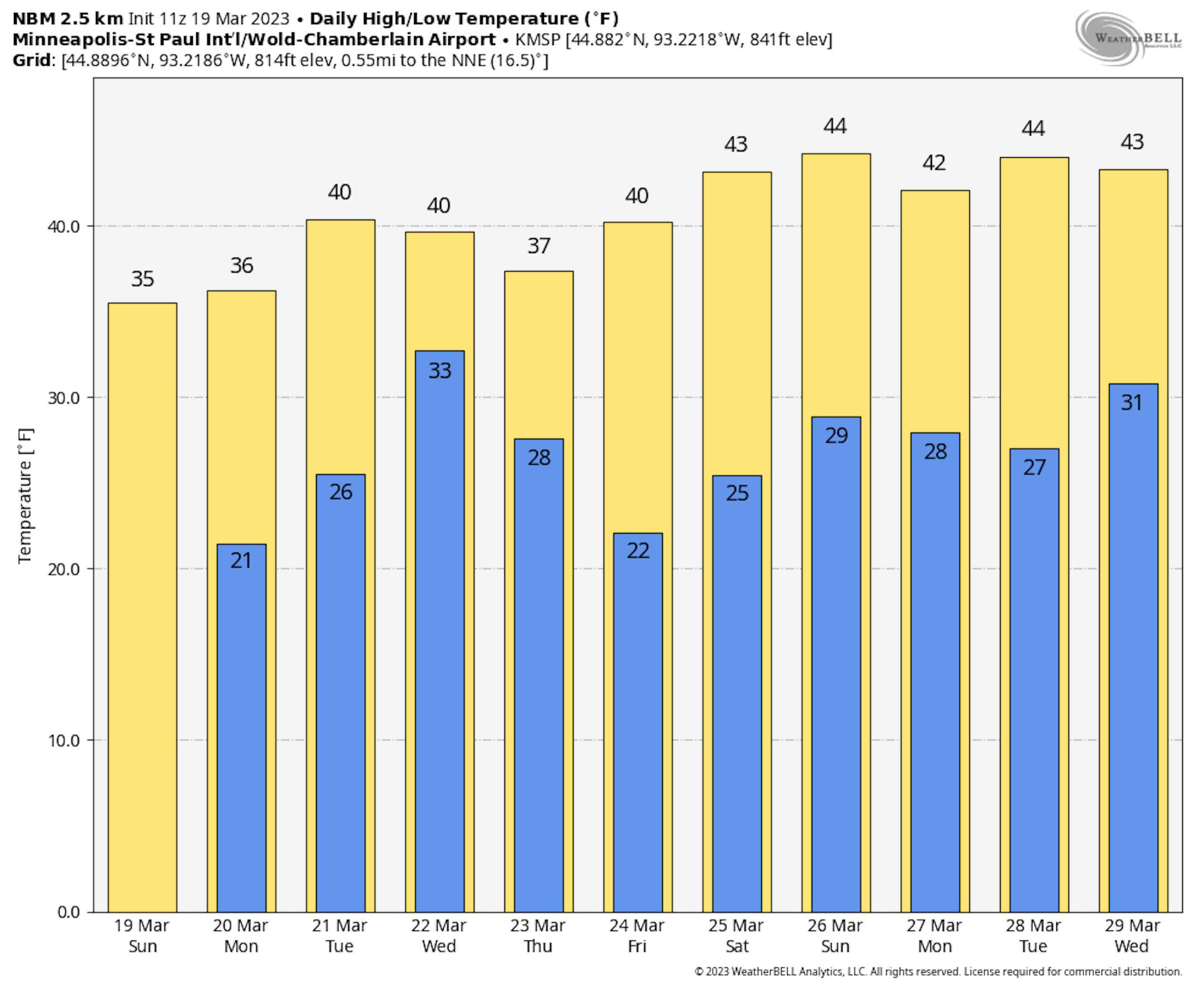
While we have seen temperatures "cool" a touch for the work week, we still will see several chances at 40F before we get to the weekend - which is when highs in the mid-40s start to become more likely at this time.

_______________________________________________

Mid-Week Precipitation Chances

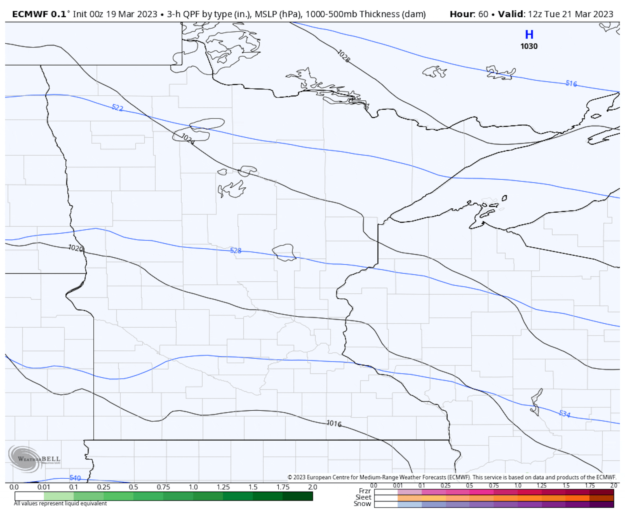
3-Hour Precipitation Loop From 7 AM Tuesday To 7 PM Wednesday

We'll watch our next system start to impact the region late Tuesday into Wednesday with rain and snow chances. Surface temperatures will play a major factor in what precipitation we do see farther south (including areas like the metro) - however, with much of the precipitation falling in the Tuesday Night to early Wednesday timeframe in central and southern Minnesota, snow accumulation is expected. Right now, we're looking at a band of 2-5" of snow falling from Canby to Willmar, Clearwater, and North Branch and northward to the Canadian border. A few 6"+ totals could be possible along the North Shore for areas like Two Harbors and Silver Bay.

3-Hour Precipitation Loop From 7 PM Wednesday To 7 PM Thursday

While there is still some uncertainty in the models regarding a second system impacting the region as we head into Thursday, a more southern path continues to be favored. This means precipitation would mainly occur south of Minnesota. We'll keep an eye on it - we're of course bound to see some wiggle in the models - and keep you updated on both these systems this week!

_______________________________________________

Astronomical Spring Arrives Later Today
By Paul Douglas

Spring is in the air. Well, not really – but can we pretend? It's only right, because astronomical spring, the Vernal Equinox, arrives today at 4:24pm, as the sun's direct rays fall on the equator.

[Paul impatiently checks his watch] Where are all the warm fronts? A few robin (and accountant) sightings, but still no skeeters, daffodils or raging allergies to report. Get ready for a slow-motion spring this year; a good thing considering the 3-6" of water tied up in our glacial snow pack.

The stinging January relapse is over - daytime highs nudge 40F much of this week. Clouds increase today with upper 30s and a few dripping drainspouts. Tuesday's storm may drop a little slush on the metro by nightfall, but a mix of snow and rain should keep any amounts down at MSP. The northern half of Minnesota may pick up plowable amounts of snow by Wednesday, but late week storms should pass south of Minnesota.

All this snow will slow the rate of warming in coming weeks but spring green-up is about 4-5 weeks away!

_______________________________________________

Paul's Extended Twin Cities Forecast

MONDAY: Mix of clouds and sun. Wake up 22. High 36. Chance of precipitation 10%. Wind NE 10-15 mph.

TUESDAY: Rain-snow mix arrives late. Wake up 27. High 40. Chance of precipitation 90%. Wind E 10-20 mph.

WEDNESDAY: Wet start, windy with slow clearing. Wake up 31. High 37. Chance of precipitation 40%. Wind W 15-25 mph.

THURSDAY: Sunny and pleasant. Wake up 21. High 39. Chance of precipitation 10%. Wind NW 8-13 mph.

FRIDAY: Partly sunny, feels like March. Wake up 18. High 41. Chance of precipitation 10%. Wind NE 5-10 mph.

SATURDAY: Intervals of sunshine, quiet. Wake up 24. High 42. Chance of precipitation 20%. Wind SE 5-10 mph.

SUNDAY: Mostly cloudy, flurries at night? Wake up 29. High 37. Chance of precipitation 40%. Wind SE 7-12 mph.

_______________________________________________

Minneapolis Weather Almanac And Sun Data
March 20th

*Length Of Day: 12 hours, 8 minutes, and 51 seconds
*Daylight GAINED Since Yesterday: 3 minutes and 9 seconds

*When do we see 13 Hours of Daylight?: April 6th (13 hours, 2 minutes, 7 seconds)
*When Is The Sunrise At/Before 7 AM? March 29th (6:59 AM)
*When Is The Sunset At/After 8 PM? April 17th (8:00 PM)

_______________________________________________

This Day in Weather History
March 20th

1991: An early season tornado hits Faribault county from Bricelyn to Wells.

_______________________________________________

National Weather Forecast

Active weather is expected in the western United States on Monday, with showers and snow showers expected in many areas. Some wintry precipitation will continue to be possible around the Great Lakes, with storms down in southern Florida.

Several inches of snow will be expected to accumulate in the western mountains through the first couple days of the work week, with several feet across portions of the Sierra. The heaviest rain will be along and near areas of the west coast (especially in California) where over 3" will be possible.

_______________________________________________

The worst cities in the U.S. for allergies

More from the Washington Post: "If you live in the U.S. Midwest, buckle up for an intense allergy season … for the rest of your life. Allergy season is becoming more intense across the country, lasting longer and with more pollen in the air. That's bad news for the more than 60 million people in the United States who suffer from allergy-related sneezing, congestion and watery eyes. And just like brands of tissues, not all pollen-induced sneeze-fests are equal. Some places have it especially bad. A report released Wednesday by the nonprofit Asthma and Allergy Foundation of America revealed last year's U.S. "allergy capitals." These were the most challenging places to live for those with pollen allergies. The rankings were based on pollen counts and took into account use of over-the-counter medication and the number of allergy physicians in the area."

These Small- and Medium-Sized States Punch Above Their Weight in Renewable Energy Generation

More from Inside Climate News: "It's not surprising that gigantic states like Texas and California are heavy hitters in generating some of the most electricity from wind and solar. But what if we look at generation per square mile of land? Then, the leader is Iowa. Iowa generated 806.7 megawatt-hours per square mile in 2022 from wind and solar, most of which was from wind, based on data from the Energy Information Administration. Rhode Island was next with 626.7 megawatt-hours per square mile, most of which was from solar."

Minimizing electric vehicles' impact on the grid

More from MIT News: "National and global plans to combat climate change include increasing the electrification of vehicles and the percentage of electricity generated from renewable sources. But some projections show that these trends might require costly new power plants to meet peak loads in the evening when cars are plugged in after the workday. What's more, overproduction of power from solar farms during the daytime can waste valuable electricity-generation capacity. In a new study, MIT researchers have found that it's possible to mitigate or eliminate both these problems without the need for advanced technological systems of connected devices and real-time communications, which could add to costs and energy consumption. Instead, encouraging the placing of charging stations for electric vehicles (EVs) in strategic ways, rather than letting them spring up anywhere, and setting up systems to initiate car charging at delayed times could potentially make all the difference."

_______________________________________________

Follow me on:

Thanks for checking in and have a great day!

- D.J. Kayser