Cool Weather Continues This Week - Rain Possible Thursday Into Friday

Cool air continues to sit across the region, with highs mainly in the 50s this week for the metro (maybe approaching 60F on Wednesday). The first half of the week is dry, but we'll track rain chances for Thursday and Friday. - D.J. Kayser

October 9, 2023 at 12:00AM
(The Minnesota Star Tribune)

Fall Color Update

(The Minnesota Star Tribune)

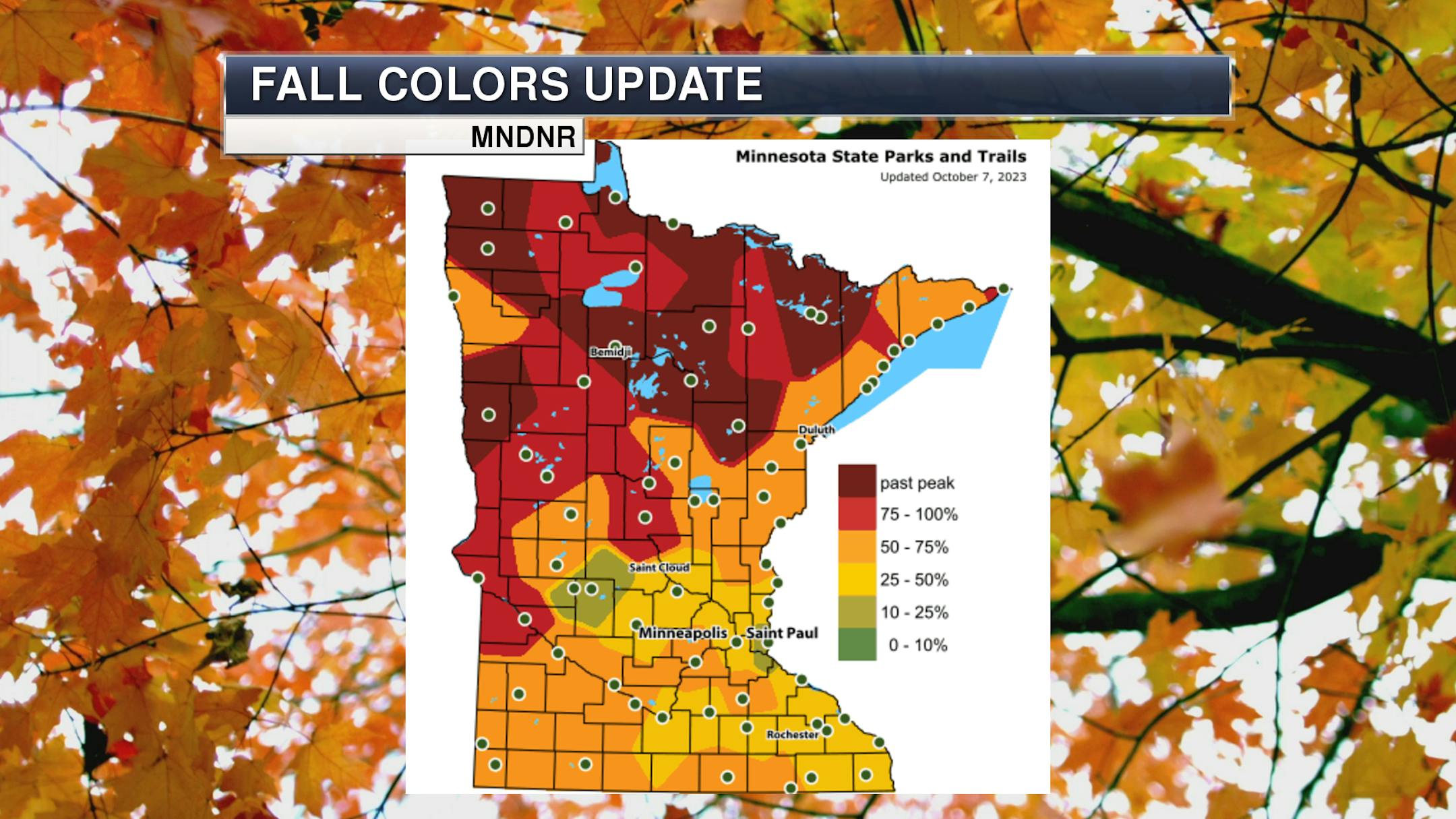
A good chunk of northern Minnesota is near or past peak, with most of the rest of the state at least 25-50% turned according to the latest update from the Minnesota DNR Fall Color Finder. The weather (windy and, a few days ago, rainy) is definitely taking a toll on some of the leaves across the state - and frosty weather will help that continue over the next several days. Interstate State Park reported on Sunday: "Many trees changed and dropped their leaves early this year in the wind and rain. Most of the brightly colored sugar maple leaves have already fallen. What remains throughout the park is a mix of still-green trees and bare trees among muted patches of pale yellows, oranges and browns. A second wave of more subtle fall colors may happen in another week as oak leaves turn rusty brown and red and silver maples near the river turn a pale gold. This final color change is typically not as bright and brilliant as the earlier maples."

_______________________________________________

Frosty/Freezing Mornings Ahead

(The Minnesota Star Tribune)

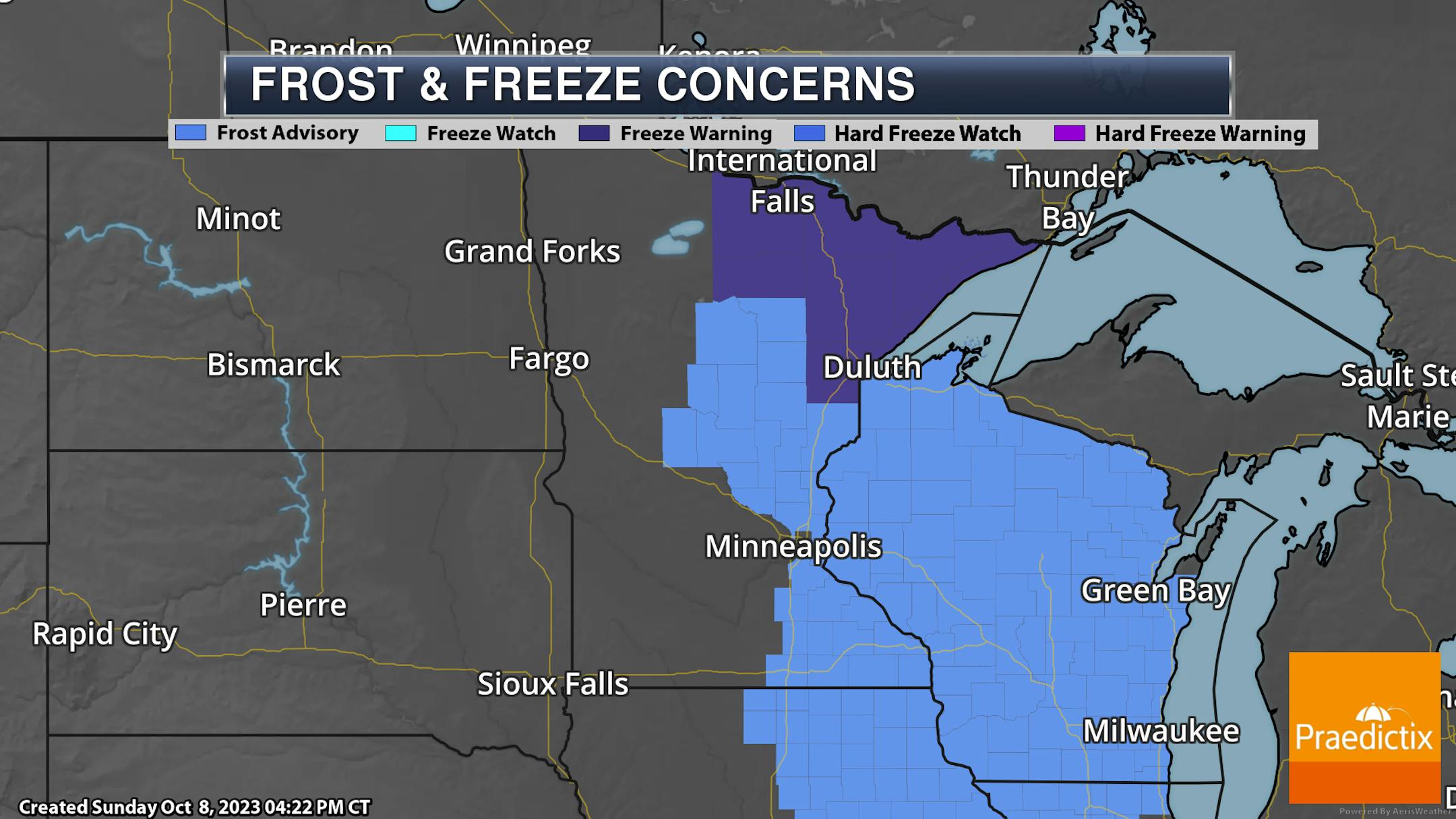
For Sunday Night, Freeze Warnings are in place across northern Minnesota where temperatures could drop as low as 29F. Meanwhile, Frost Advisories are in place across parts of eastern Minnesota into all of Wisconsin as temperatures drop into the low and mid-30s allowing for frost formation. Sunday Night is one of the next several nights where you'll want to either cover up your vegetation outside or bring it in.

(The Minnesota Star Tribune)

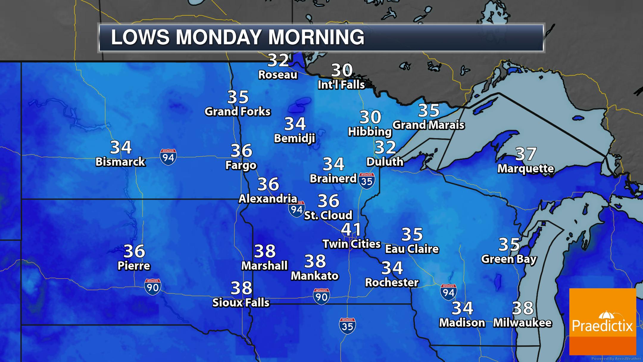
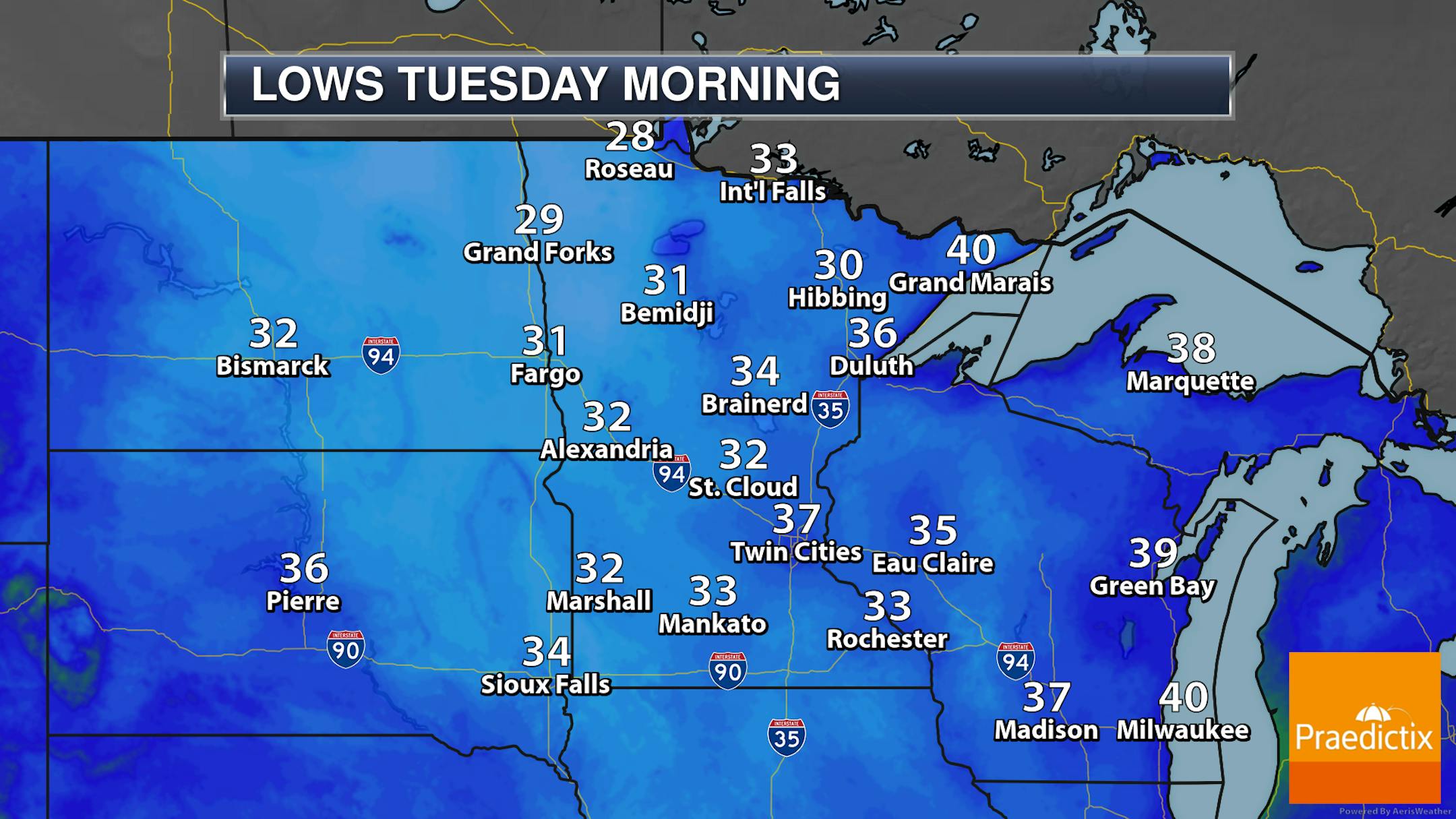
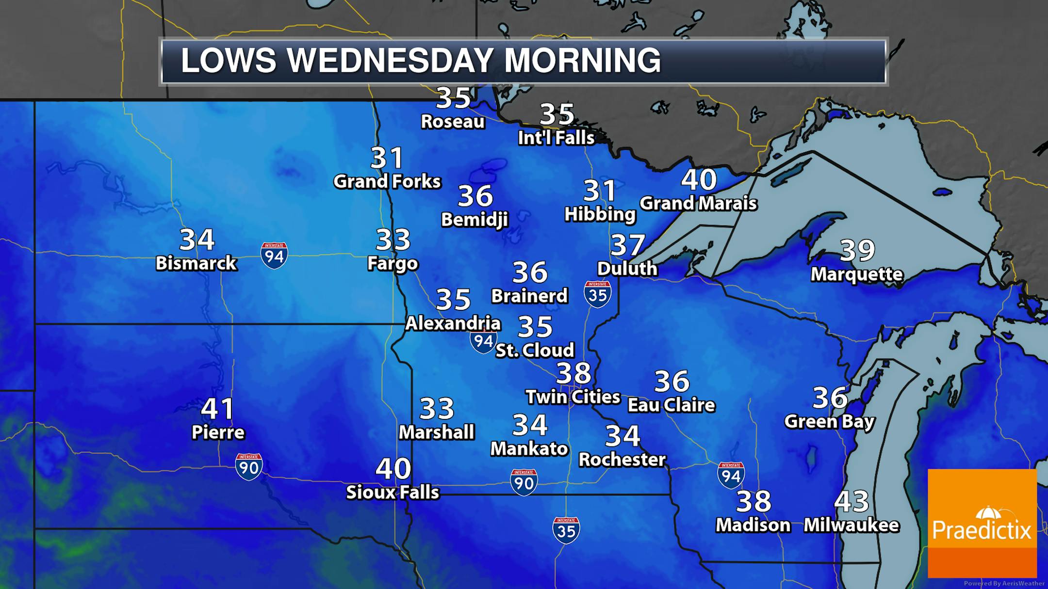
The coldest morning of the next several in the Arrowhead looks to be Monday morning, with Tuesday morning being the coldest for most of the rest of the state - including here in the metro. These temperatures will likely bring an end to the growing season across much of the state (if it hasn't already technically "ended" over the past few mornings).

_______________________________________________

Mainly Sunny Monday

(The Minnesota Star Tribune)

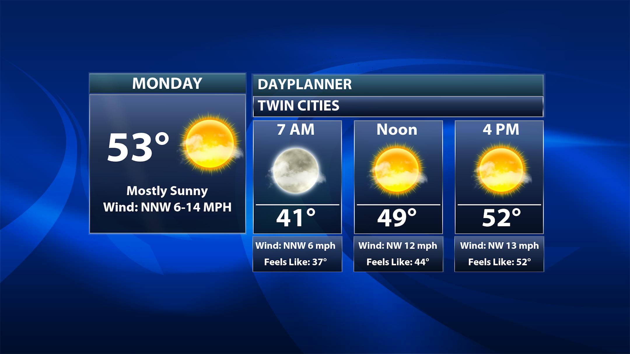
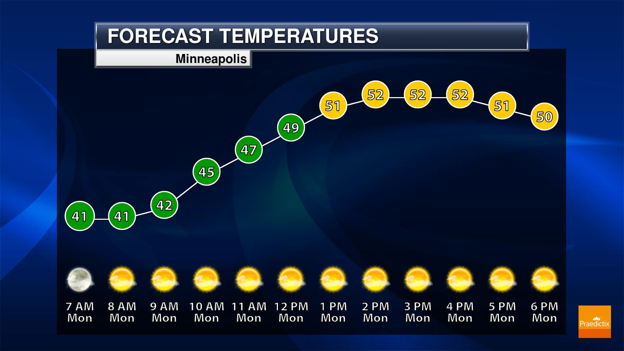
While we could start off with a few clouds in the metro on Monday, I believe we'll see mainly sunny skies throughout much of the day. Morning temperatures start off around 40F in the heart of the metro, with highs climbing to the low 50s.

(The Minnesota Star Tribune)

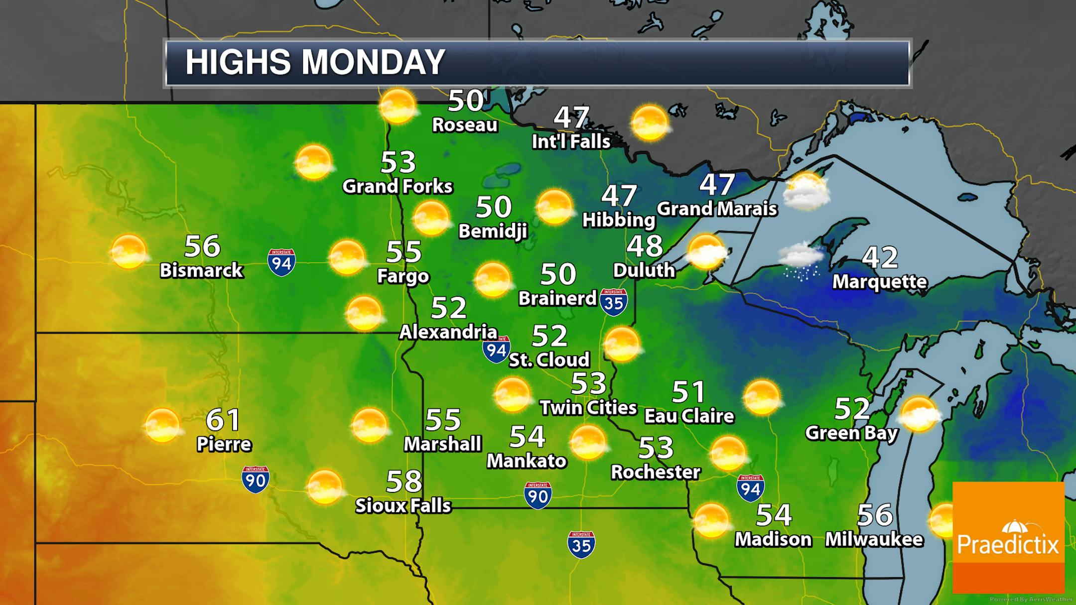
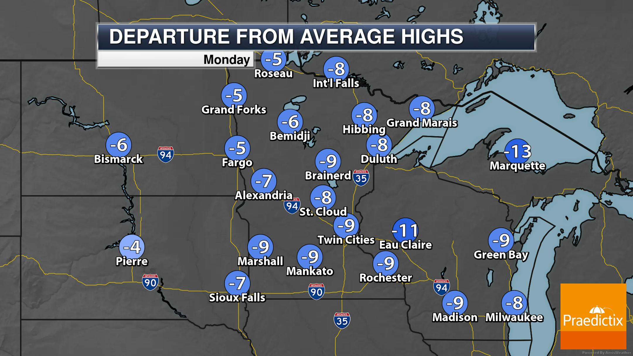
While most of the state will see mainly sunny skies, we will see more clouds than sun up in the Arrowhead throughout the day. Highs will be in the 40s and 50s across Minnesota on Monday - which will be 5-10F degrees below average.

_______________________________________________

Highs In The 50s Continue This Week - Rain Chances Thursday Into Friday

(The Minnesota Star Tribune)

Below-average highs will continue over the next week here in the metro, with afternoon temperatures climbing into the 50s each day - definitely fall-like (finally!). The warmest day looks to occur on Wednesday when we could see highs approach 60F. We will see a sun/cloud mix through the middle of the week with more clouds and the potential of rain as we head into Thursday and Friday.

(The Minnesota Star Tribune)

Forecast loop showing 3-hour precipitation from 7 AM Thursday to 7 PM Friday.

As we head toward the second half of the week, we are watching a system that'll move from the Central Plains to the Great Lakes. While the bulk of the system looks to pass to our south, it does appear that southern and central Minnesota will be on the northern side of the rain shield with the system. This could produce another round of good rainfall in the region - especially on Thursday and Friday.

(The Minnesota Star Tribune)

48-Hour Potential Rain Through 7 PM Friday

The most beneficial rains expected at the moment from this system will be in southern Minnesota (mainly south of the metro) where the potential will exist for 1-2" of rain. Rainfall tallies taper off the farther north you are, with less than a quarter inch in the Duluth area and pretty much nothing from Fargo to Hibbing.

_______________________________________________

Paul, I Have Some Weather Questions
By Paul Douglas

People have questions, and here are a few of the queries I've gotten in recent days in no particular order. "Paul, have we seen the last mild weather of the season?" Probably not. The weather is cyclical, but the current cool cycle should reverse itself with more 60s, even a shot at 70F later in October. I suspect some brave souls will be boating (and golfing) deep into October.

"Paul, will we see another extra-snowy winter?" Probably not. You can thank (or blame) a strong El Nino warm phase of the Pacific, which usually results in less snow for the Upper Midwest.

A storm stalled south of Hudson Bay, Canada will keep us cool all week with a string of 50-degree highs. Models spin up a potentially soaking rain storm from late Thursday into Saturday and amounts may be significant. The western US stays unusually warm, and some of that warmth may reach Minnesota the third week of October.

Last year first flakes at MSP came October 13 with .4" snow on the 14th. Snow will come later this fall - but it's coming.

_______________________________________________

Paul's Extended Twin Cities Forecast

MONDAY: Partly sunny, breezy. Wake up 39. High 53. Chance of precipitation 10%. Wind NW 10-20 mph.

TUESDAY: Bright sunshine. Wake up 38. High 56. Chance of precipitation 0%. Wind NW 8-13 mph.

WEDNESDAY: Blue sky. Clouds arrive later. Wake up 37. High 59. Chance of precipitation 10%. Wind E 5-10 mph.

THURSDAY: Dry start. Rain comes in late PM. Wake up 45. High 53. Chance of precipitation 80%. Wind NE 15-25 mph.

FRIDAY: Rain may be heavy at times. Wake up 46. High 51. Chance of precipitation 100%. Wind NE 20-40 mph.

SATURDAY: Blustery with showery rain. Wake up 45. High 50. Chance of precipitation 70%. Wind NW 15-30 mph.

SUNDAY: Mostly cloudy, cool breeze. Wake up 45. High 54. Chance of precipitation 20%. Wind N 10-20 mph.

_______________________________________________

Minneapolis Weather Almanac And Sun Data
October 9th

(The Minnesota Star Tribune)

*Length Of Day: 11 hours, 18 minutes, and 10 seconds
*Daylight LOST Since Yesterday: 3 minutes and 4 seconds

*When Do We Drop Below 11 Hours Of Sunlight? October 15th (10 hours, 59 minutes, 51 seconds)
*When Are Sunrises At/After 7:30 AM? October 17th (7:31 AM)
*When Are Sunsets At/Before 6:30 PM? October 14th (6:30 PM)
_______________________________________________

This Day in Weather History
October 9th

1970: Montevideo sets a record low high temperature of 35.

1938: Forest fires on the 9th and 10th claim 21 lives in northern Minnesota.

_______________________________________________

National Weather Forecast

(The Minnesota Star Tribune)

A frontal boundary moving into the Pacific Northwest will bring rain and higher-elevation snow chances on Monday. Showers will continue across the Great Lakes with an area of low pressure in southern Canada. Other areas of rain or storms are possible in parts of the Northeast and Mid-Atlantic, southern Florida, southern Texas, and the Desert Southwest.

(The Minnesota Star Tribune)

Some of the heaviest rain through the first couple days of the week will fall along the Northwestern coast, with rainfall tallies up to 3" possible. We will also see heavier rainfall continue downwind of the Great Lakes - particularly of Lake Ontario, where Sunday-Tuesday rainfall amounts over 3" are possible.

(The Minnesota Star Tribune)

That Pacific Northwest system could also produce some snowfall up in the Cascades through the beginning of the week.

_______________________________________________

Plants could make air pollution worse on a warming planet

More from Michigan State University: "It's a simple question that sounds a little like a modest proposal. "Should we cut down all the oak trees?" asked Tom Sharkey, a University Distinguished Professor in the Plant Resilience Institute at Michigan State University. Sharkey also works at the MSU-Department of Energy Plant Research Laboratory and in the Department of Biochemistry and Molecular Biology. To be clear, Sharkey wasn't sincerely suggesting that we should cut down all the oaks. Still, his question was an earnest one, prompted by his team's latest research, which was published in the scientific journal Proceedings of the National Academy of Sciences. The team discovered that, on a warming planet, plants like oaks and poplars will emit more of a compound that exacerbates poor air quality, contributing to problematic particulate matter and low-atmosphere ozone."

Simultaneous large wildfires will increase in Western U.S.

More from NCAR & UCAR News: "Simultaneous outbreaks of large wildfires will become more frequent in the Western United States this century as the climate warms, putting major strains on efforts to fight fires, new research shows. The new study, led by scientists at the National Center for Atmospheric Research (NCAR), focused on wildfires of 1,000 acres or larger. It found that wildfire seasons in which several such blazes burn concurrently will become more common, with the most severe seasons becoming at least twice as frequent by the end of this century. ... "Higher temperatures and drier conditions will greatly increase the risk of simultaneous wildfires throughout the West," said NCAR scientist Seth McGinnis, the lead author of the study. "The worst seasons for simultaneous fires are the ones that are going to increase the most in the future.""

All 2024 Ford F-150 Lightnings Come With A Heat Pump. Here's Why That's A Big Deal

More from InsideEVs: "The entire 2024 Ford F-150 Lightning lineup will come standard with a heat pump system, a highly desired electric vehicle feature that will likely improve cold weather efficiency. A growing number of EVs today come with heat pumps, so it was a surprising omission when Ford announced the F-150 Lightning wouldn't have such a system. That was especially true, since the Lightning isn't a budget EV, and certainly has the physical space to incorporate such a system. EVs with heat pumps include the whole Tesla lineup, the BMW i4 and iX, Hyundai's Ioniq cars and their Kia and Genesis cousins, and now Ford's electric pickup."

_______________________________________________

Follow me on:

Thanks for checking in and have a great day!

- D.J. Kayser

(The Minnesota Star Tribune)

about the writer

D.J. Kayser

See More