Foggy Start Sunday - A Few Storms Around, But Mostly Dry Day

After some fog in spots to start your Sunday, we will see mainly dry weather in the metro with just some roaming showers and storms (better chance later in the day). More rain chances with above average temperatures are expected this week into Fishing Opener/Mother's Day weekend. - D.J. Kayser

May 7, 2023 at 12:05AM
(The Minnesota Star Tribune)

Storm Chances Continue & Push North Saturday Night

(The Minnesota Star Tribune)

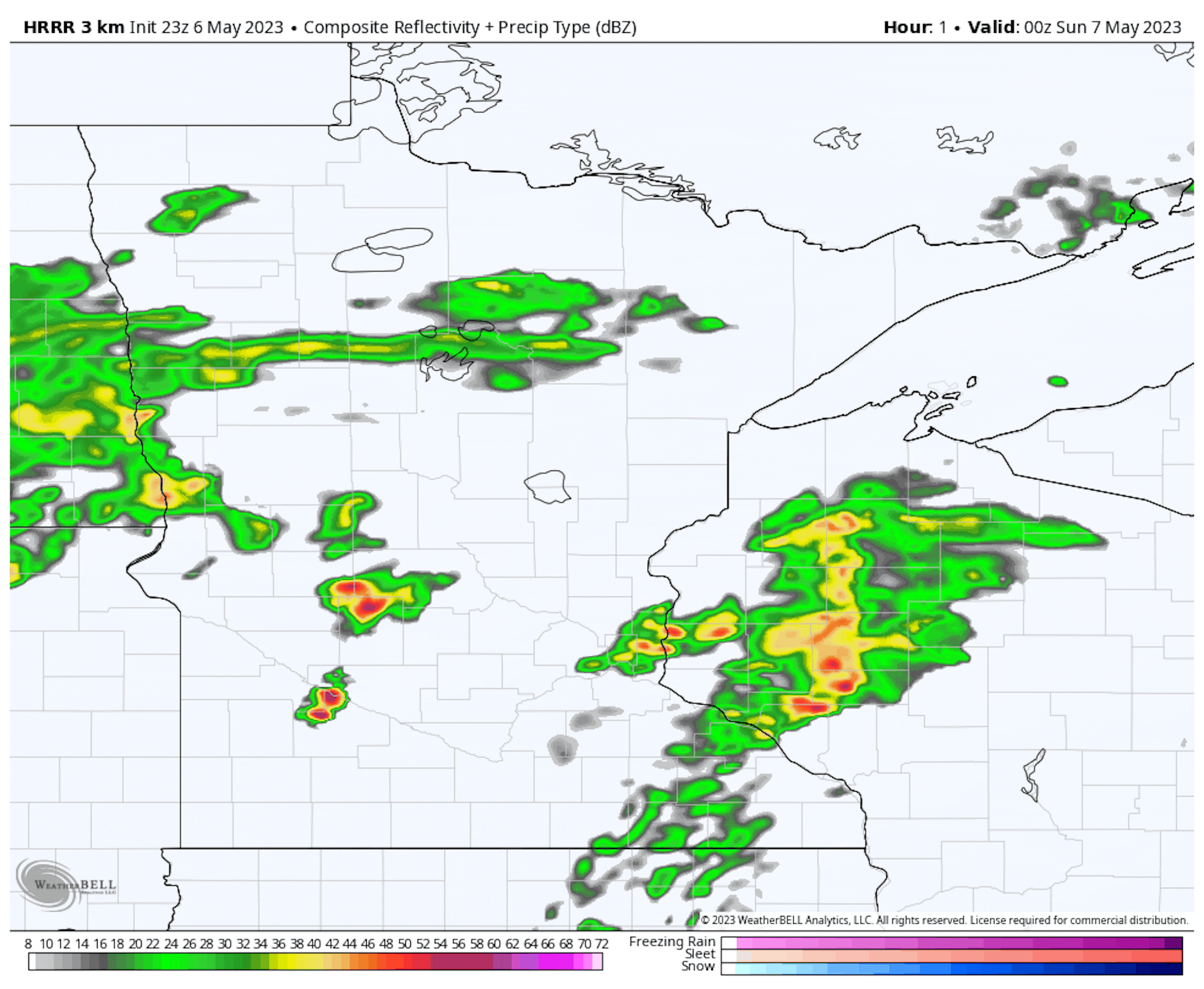
Forecast loop between 7 PM Saturday and 7 AM Sunday.

As we work into Saturday Night, we will continue to watch shower and storm potential across the state. For the most part, this rain chance will continue to push north and east into the overnight hours, with storm chances decreasing in the metro (especially after midnight).

(The Minnesota Star Tribune)

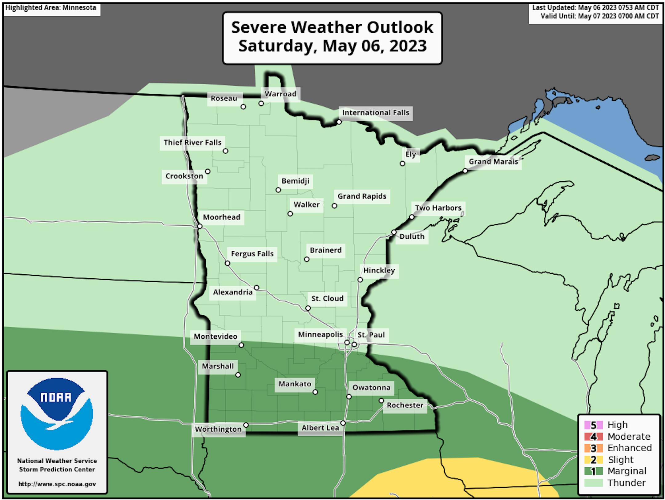
A few storms Saturday evening across southern Minnesota could be strong with a Marginal Risk of severe weather (threat level 1 of 5) in place. A couple tornado touchdowns were reported in the 6 PM hour Saturday evening near Prinsburg in southern Kandiyohi County.

(The Minnesota Star Tribune)

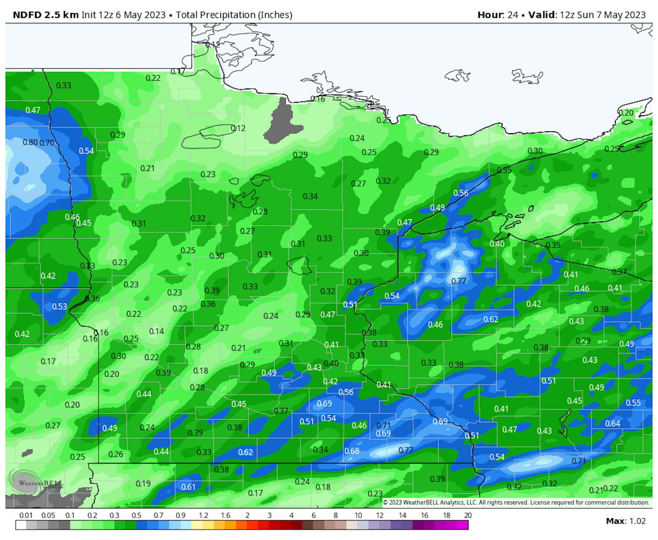
Expected rain Saturday to 7 AM Sunday.

From the rain we saw during the day Saturday through Saturday Night, we could see half an inch or more add up across portions of the state.

_______________________________________________

Sunday: Mostly Dry, Storm Chances Late

(The Minnesota Star Tribune)

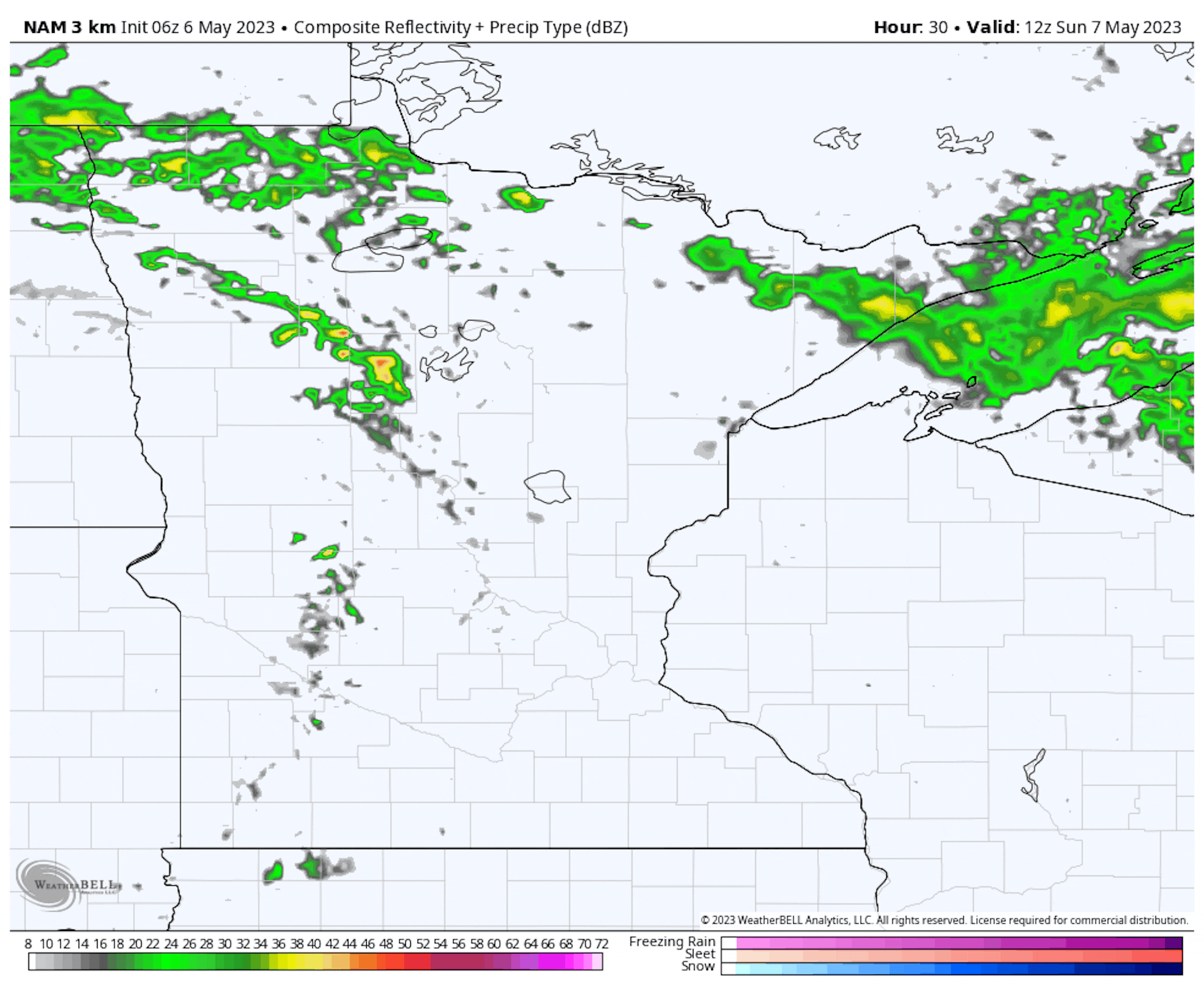
Forecast loop between 7 AM Sunday and 7 AM Monday.

While I can't rule out a few roaming storms across central and southern Minnesota during the daytime hours Sunday, the best chance of seeing rain during this timeframe will be up across portions of northern Minnesota. The next wave moves in as we head toward Sunday Night, and while it does look weak at the moment, it could help spark at least a few scattered showers and storms across southern and central Minnesota.

(The Minnesota Star Tribune)

Expected rain Sunday Night.

This next round could once again produce some half-inch or higher rain tallies, mainly across southeastern Minnesota, as we head through Sunday Night.

(The Minnesota Star Tribune)

A few storms could also approach severe limits in far southern Minnesota, with hail and wind again the primary threats.

(The Minnesota Star Tribune)

Looking at temperatures across the state, they'll range from around 10F degrees below average in Duluth with highs in the 50s across northern Minnesota to highs around 10F above average in southern parts of the state with highs in the 70s. I would not be surprised to see some fog in the morning hours.

(The Minnesota Star Tribune)

I do anticipate that we'll start the day with at least patchy areas of fog in the metro and surrounding areas, otherwise, I would expect a mix of sun and clouds to mainly cloudy skies throughout the day. We will watch those isolated storm chances, especially later in the day (but I can't rule it out in the morning either). Morning temperatures start out in the upper 50s with highs in the mid-70s - several degrees warmer than Saturday.

_______________________________________________

Cloud Cover For The Aurora Sunday Night?

(The Minnesota Star Tribune)

Meanwhile, a couple of CMEs launched off the sun early Friday morning that appear to have an Earth-directed component. This Earth-directed component could reach the Earth sometime Sunday, sparking the northern lights. NOAA's Space Weather Prediction Center has the highest Kp forecast between 3-6z Monday, which in Twin Cities time is 10 PM Sunday to 1 AM Monday - however, elevated values would allow the aurora to occur in the hours surrounding that peak as well.

(The Minnesota Star Tribune)

Forecast cloud loop from 9 PM Sunday to 5 AM Monday.

Now for the potentially bad news: cloud cover could skunk out most of the state from seeing the aurora as we head through Sunday Night. The other thing that could work against seeing a nice aurora show is the almost full moon, which will rise Sunday night at 11:21 PM.

_______________________________________________

Staying Above Average With More Rain Chances

(The Minnesota Star Tribune)

Starting with the temperatures, warm weather will continue after Sunday here in the metro, with highs generally in the 70s expected. The coolest day will be Tuesday with highs only in the upper 60s.

(The Minnesota Star Tribune)

Forecast loop from 7 AM Monday to 7 PM Thursday.

We will also continue to watch more rain chances across the state as we head through next week. Right now the best chances in the metro appear to be later Monday into early Wednesday, and again later in the week.

(The Minnesota Star Tribune)

Forecast rain from 7 AM Monday through 7 AM Saturday.

The rounds of rain throughout the work week could bring another 1"+ of rain across portions of central and southern Minnesota.

_______________________________________________

Fishing Opener Next Saturday: Wet?

(The Minnesota Star Tribune)

Forecast loop between 7 AM next Saturday and 7 AM next Sunday.

As we head toward the Fishing Opener next Saturday, it does look like it could be a wet one across the state - especially in northern and central Minnesota.

(The Minnesota Star Tribune)

Highs will look to be in the 70s across most of the state next Saturday, with 60s sticking around in the Arrowhead and along the North Shore.

_______________________________________________

Mother's Day Next Sunday: Drier?

(The Minnesota Star Tribune)

Forecast loop between 7 AM next Sunday and 7 AM next Monday.

Meanwhile, it looks like Mother's Day next Sunday could start off on the wetter side, but drier weather would move in by the afternoon hours.

(The Minnesota Star Tribune)

Warm conditions continue for Mother's Day, with 70s across much of the state. The only areas that could hold back in the 60s would be near and along the North Shore.

_______________________________________________

Better Outdoor Day Today - Showery Week On Tap

By Paul Douglas

Here in the Land of 10,000 Weather-Related Migraines you should have a half dozen ways to receive time-critical severe storm information. We are prone to short attention spans and staring at our phones, which should activate a high-pitch tone if dangerous weather is near your GPS location.

Here's the thing: a tornado warning will not interrupt your Spotify feed. A flood warning will not show up on Netflix or Hulu. Multiple safety nets are necessary to make sure you get the information you need to protect life and property with time to spare.

Legacy media and NOAA Weather Radio are still very good insurance policies. Remember, sirens were only meant for outdoor use. The more options, the better your odds.

Skies brighten today with 70s and a stray late-day thundershower. A pesky frontal zone lingers nearby into midweek, sparking random showers and storms. 70s may give way to a few 80s by late week, with sticky humidity and heavy T-storms for the Fishing Opener on Saturday. Hey, no snow or wind chill!

_______________________________________________

Paul's Extended Twin Cities Forecast

SUNDAY: Partly sunny, late T-storm. Wake up 58. High 77. Chance of precipitation 40%. Wind SW 8-13 mph.

MONDAY: Plenty of sun, quite pleasant. Wake up 56. High 73. Chance of precipitation 20%. Wind NE 8-13 mph.

TUESDAY: Few showers and T-storms. Wake up 54. High 71. Chance of precipitation 60%. Wind NE 5-10 mph.

WEDNESDAY: Stalled front, T-storms rumble. Wake up 56. High 76. Chance of precipitation 50%. Wind SE 7-12 mph.

THURSDAY: Some sun, getting sticky out there. Wake up 59. High 80. Chance of precipitation 20%. Wind SE 10-15 mph.

FRIDAY: Sunny and humid. Touch of late June. Wake up 58. High 82. Chance of precipitation 10%. Wind SE 10-15 mph.

SATURDAY: Muggy, strong T-storms in the area. Wake up 61. High 81. Chance of precipitation 60%. Wind S 10-15 mph.

_______________________________________________

Minneapolis Weather Almanac And Sun Data
May 7th

(The Minnesota Star Tribune)

*Length Of Day: 14 hours, 31 minutes, and 34 seconds
*Daylight GAINED Since Yesterday: 2 minutes and 34 seconds

*When do we see 15 Hours of Daylight?: May 20th (15 hours, 1 minute, 45 seconds)
*Earliest Sunrises Of The Year: June 13th-17th (5:25 AM)
*When Is The Sunset At/After 8:30 PM? May 11th (8:30 PM)

_______________________________________________

This Day in Weather History
May 7th

1916: Strong winds sweep across the state and cause dust storms over southern Minnesota. Great damage is done to standing timber in Northern Minnesota. Many fires develop, one of which would destroy 30,000,000 feet of lumber.

_______________________________________________

National Weather Forecast

(The Minnesota Star Tribune)

Shower and storm chances will exist across a good portion of the country as we head into Sunday. A few storms may be severe in the central United States, especially centered around Omaha and Des Moines. Some snow showers will also be possible at higher elevations out west. The best chance of dry weather will be in the Southwest and in parts of New England and Florida, though a few storms could be around for the F1 Miami Grand Prix Sunday afternoon. A few record highs could occur in the Central Plains.

(The Minnesota Star Tribune)

Parts of the central United States will continue to see heavier rain through the rest of the weekend and early next week, with some areas potentially seeing up to around 3" of rain. Several inches of snow could accumulate in some of the mountain ranges out west.

_______________________________________________

A black eye for green energy? Renewable energy growth brings mounting waste challenge

More from CBS News: "Driven primarily by wind and solar power, renewable energy sources surpassed coal for electricity generation in the United States last year, marking a significant milestone. However, as the industry expands, a new problem emerges: what to do with the mounting waste generated by worn-out solar panels and wind turbine blades. More than 90% of discarded solar panels end up in landfills. By 2030, the retired panels are estimated to cover an area equivalent to about 3,000 football fields. But the panels, primarily composed of glass and aluminum, contain valuable and reusable materials. At a solar panel recycling plant in Yuma, Arizona, Adam Saghei, CEO of We Recycle Solar, and his company aim to tackle what he calls a "tsunami" of impending solar waste by recycling or reusing nearly 70 million pounds of solar panels annually."

Go big or start small: Picking the right scale for green hydrogen

More from Canary Media: "The push to get a global green hydrogen industry off the ground is heating up, but not everyone agrees on what the building blocks should look like. Take the example of U.S.-based startups Electric Hydrogen and Ohmium. In the past week, both have announced major plans to ramp up their production of electrolyzers, the technology used to make ​"green" hydrogen, a power source that could be key to decarbonizing heavy industries such as steelmaking, chemicals production and shipping. But one of these companies is taking a large-scale approach while the other is going smaller, as each bets on a different theory about what tactic will scale fastest and most cost-effectively, and attract the massive project financing eventually needed to grow production even larger."

Melting glaciers in Alps threaten biodiversity of invertebrates, says study

More from The Guardian: "Invertebrates living in the cool meltwater rivers of the European Alps could lose most of their habitat and disappear, as the mountain range's glaciers melt at an unprecedented rate due to climate change, according to a study. Although they are often overlooked, these animals are crucial for alpine ecosystems. Researchers focused on the mountain range of the Alps and collated data from 30 years of studies on the rate at which its glaciers are melting, and how that affects the area's river flows over time. They homed in on how past changes affected the populations of 15 species of invertebrates such as midges and stoneflies that are specialised at living in those waters."

_______________________________________________

Follow me on:

Thanks for checking in and have a great day!

- D.J. Kayser

(The Minnesota Star Tribune)

about the writer

D.J. Kayser

See More