Advertisement

Hot Week Ahead - An Isolated Strong Storm Monday?

We could see an isolated strong storm with hail or wind on Monday across the state, but the main story this week is the excessive heat that'll be in place. Highs Wednesday and Thursday could flirt with 100F in the metro, with higher heat index values. - D.J. Kayser

July 24, 2023 at 12:00AM
(The Minnesota Star Tribune)

Air Quality Alert North Of The Metro

(The Minnesota Star Tribune)

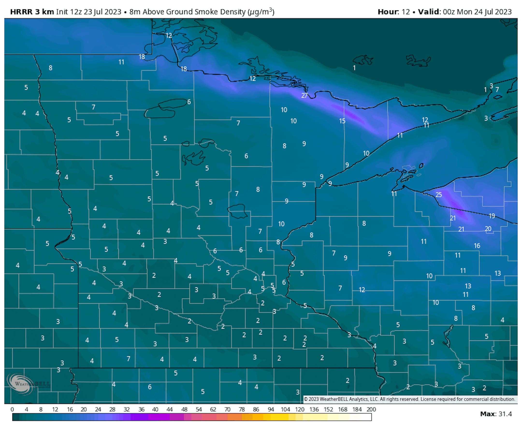
Near-surface smoke from 7 PM Sunday to 7 PM Monday.

We are continuing to watch the latest batch of Canadian wildfire smoke causing poor air quality across the region. The greatest concentration of this is up in northern Minnesota, where we will continue to see at least some smoke near the surface (though it will slowly fade away) through the daytime hours on Monday. However, some of this has made it into the metro Sunday afternoon, causing unhealthy air for health-sensitive groups.

(The Minnesota Star Tribune)

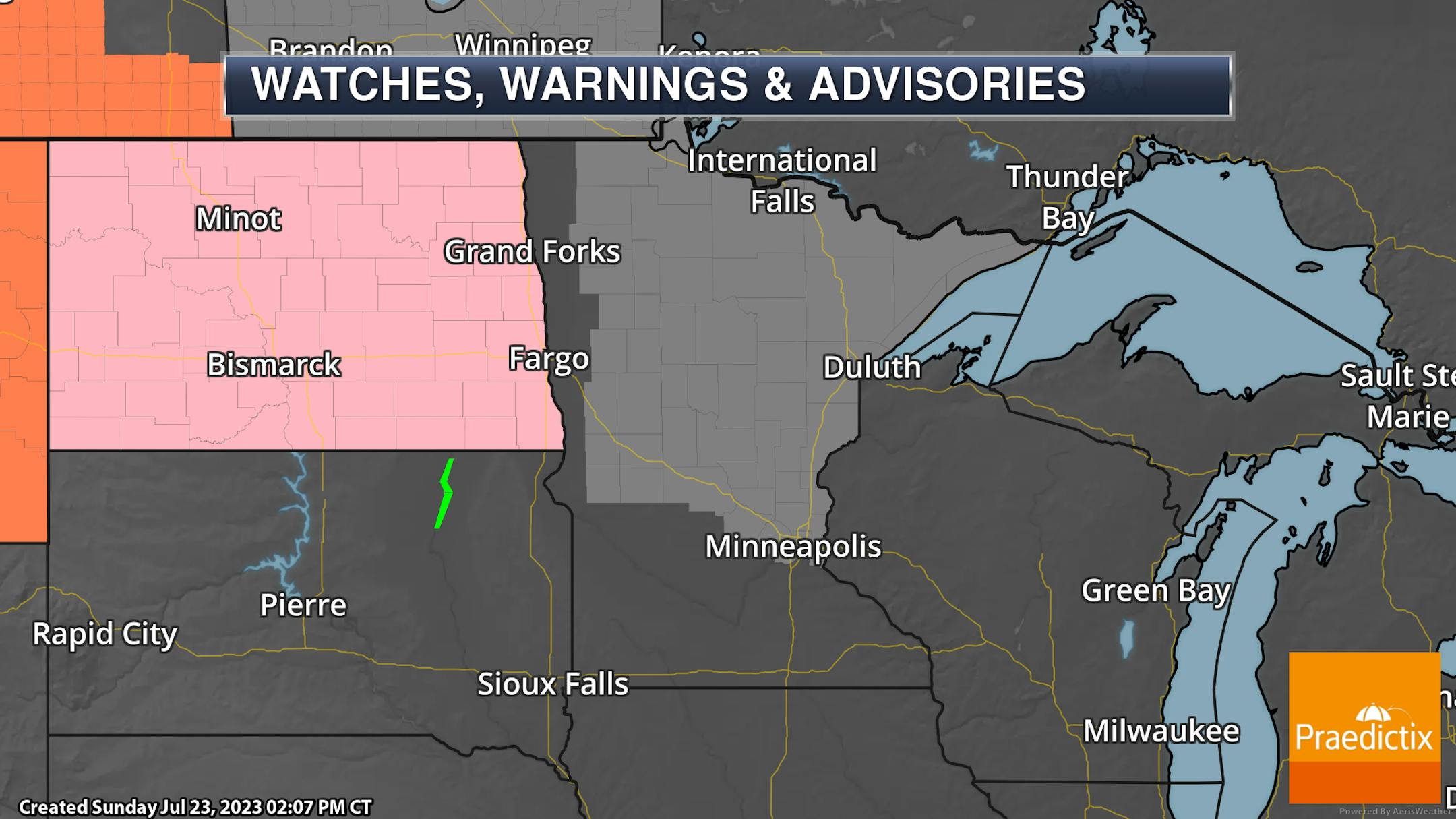
Due to the wildfire smoke causing poor air quality, an Air Quality Alert is in place for areas around the metro through 6 AM Monday, and for areas from an approximate line of St. Cloud northward through 6 PM Monday.

_______________________________________________

Hot Monday With Maybe An Isolated Strong Storm

(The Minnesota Star Tribune)

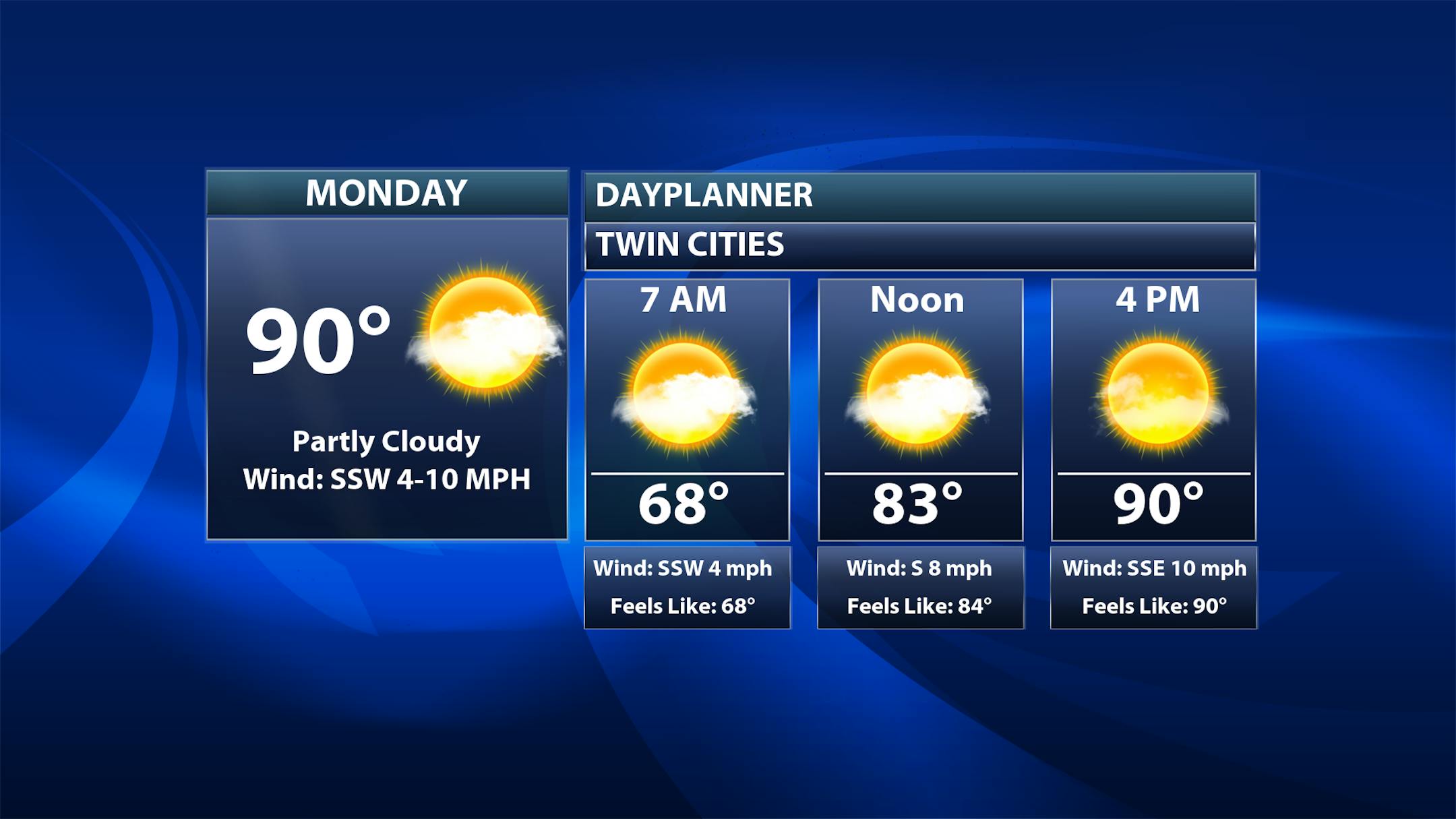
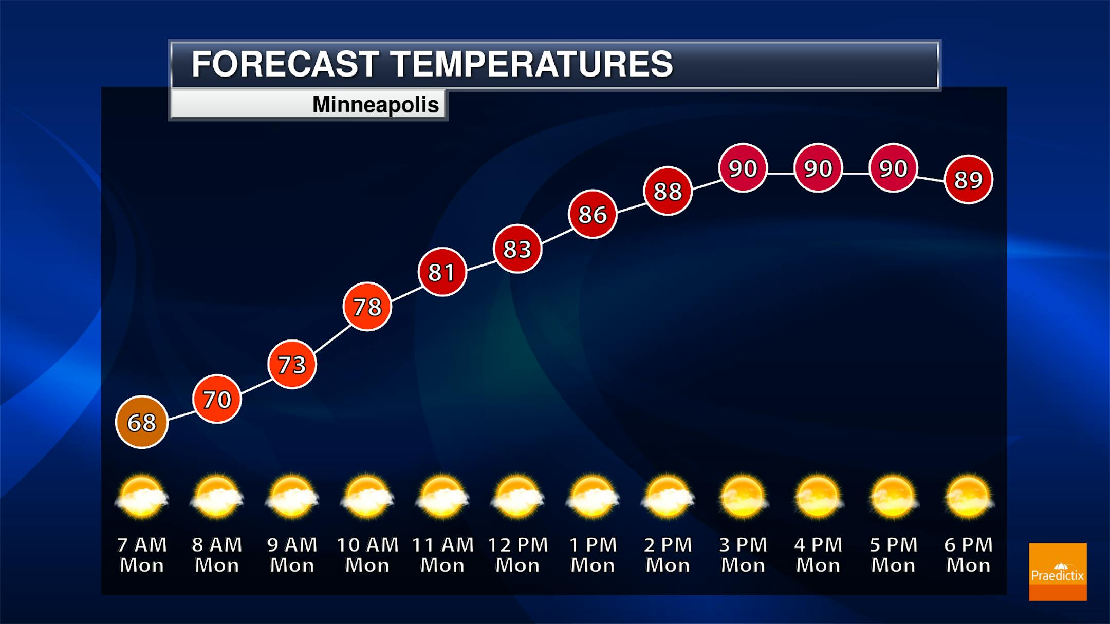
Some passing clouds are expected in the metro to begin the work week (and the last full week of July), but there will be a lot of hot sunshine out there. Morning temperatures start off in the upper 60s with highs topping off around 90F.

(The Minnesota Star Tribune)

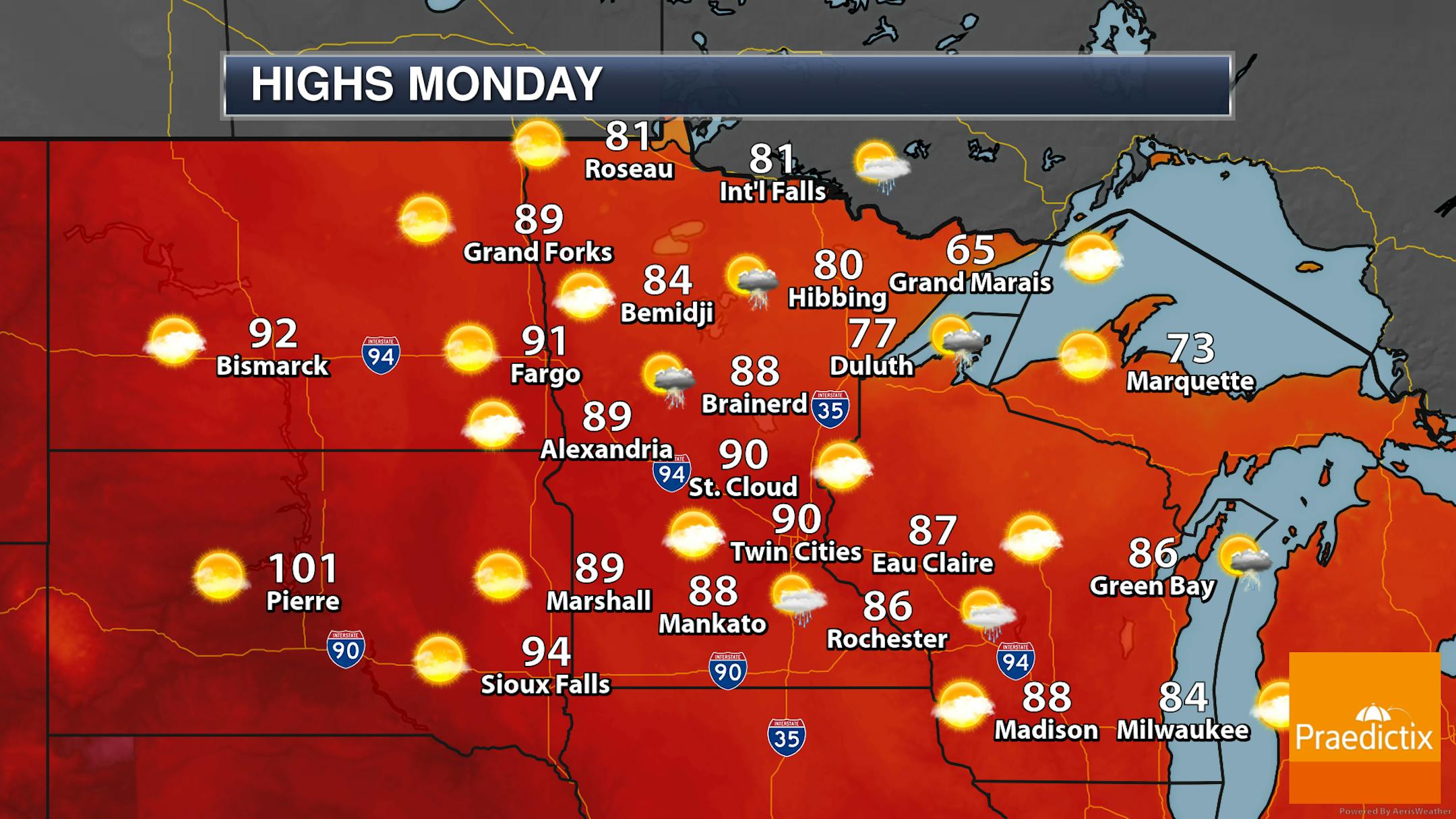
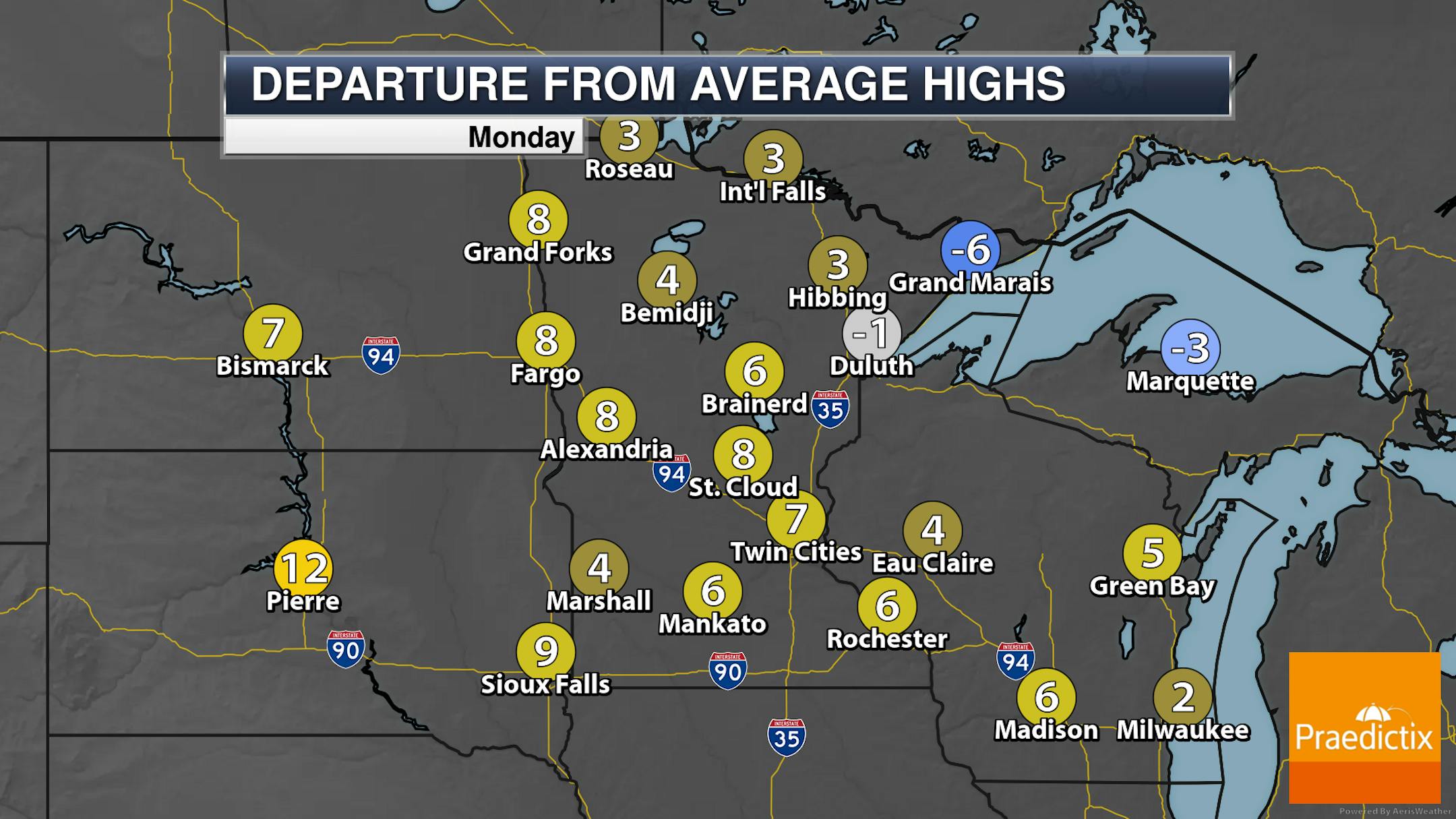
As we look statewide, we will watch the potential of a few morning storms out in western Minnesota, with a pop-up shower or two possible across the state during the afternoon hours (if we can break the atmospheric cap). Hazy skies remain due to wildfire smoke in the atmosphere, especially in northern Minnesota where some of it will have reached the surface. Temperatures range from the 60s along the North Shore (I'm jealous!!) to around 90F in southern and western Minnesota.

(The Minnesota Star Tribune)

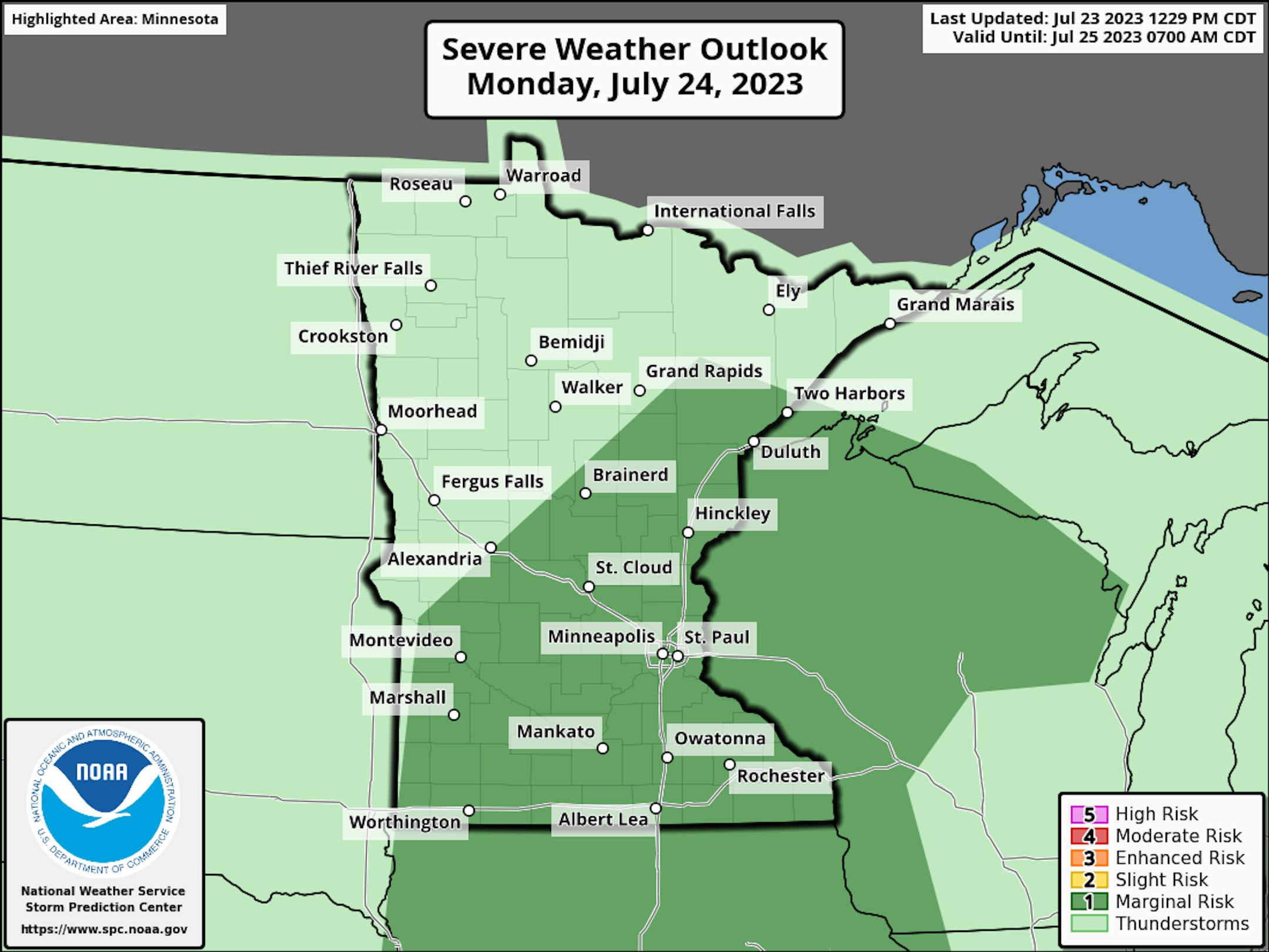
Any storms in western Minnesota that are around Monday morning could pose a hail threat Otherwise, into the afternoon hours, if we can get a storm or two to pop they could go severe with hail and wind the primary threats. However, the storm threat is likely low as the atmosphere is expected to be "capped" where storms are unable to form.

_______________________________________________

Advertisement
Advertisement

Hottest Week Of The Year Ahead?

(The Minnesota Star Tribune)

We're gearing up for what looks to be the hottest week of the year here in the metro, as an extended stretch of 90-degree days is expected. There will be a fight between Wednesday and Thursday for the hottest day of the week, both of which are expected to reach the upper 90s/up around 100F. If there's a chance to tie a record, it would be Wednesday. Overnight temperatures only drop into the 70s, so there won't be any real relief at night from the heat either - in fact, lows waking up Thursday morning are only expected to drop to around 77F in the metro.

(The Minnesota Star Tribune)

The heat index will also be a factor, as with dewpoint in the mid to upper 60s it'll feel more like the low 100s at times Wednesday and Thursday.

(The Minnesota Star Tribune)

Here's a look statewide at those two hottest days of the upcoming week - Wednesday and Thursday. The surge of 90s will reach northern Minnesota on Wednesday but be a bit more suppressed to the southern two-thirds of the state Thursday. That's partly due to a frontal boundary that'll be in place that could lead to some rogue thunderstorms.

(The Minnesota Star Tribune)

Both Wednesday and Thursday we will also watch at least an elevated to significant excessive heat risk here across portions of central and southern Minnesota - especially near the metro and the Minnesota River Valley.

_______________________________________________

Welcome To The Hottest Week Of Summer
By Paul Douglas

Advertisement

Welcome to what will probably be the hottest week of an overheated summer. I expect 5 or 6 consecutive days above 90F, adding to the 15 days of 90s the metro area has already picked up this summer season.

In theory the "heat dome" pushing into Minnesota will be hot enough for a few 100-degree highs over southern counties by midweek. And no, this will NOT be a "dry heat" either. Dew points will rise to near 70F, and I could see heat indices close to 105F the latter half of the week.

People have been helpfully reminding me that it gets hot in the summer, but a warming climate is flavoring all weather now, making heatwaves longer and stronger. NOAA data for America's top 50 cities shows heatwave season is now 49 days longer than it was in the 1960s.

Jungle-like heat and humidity may ignite a few strong to severe T-storms later this week; I wouldn't be shocked to see a derecho close to home.

80s by Sunday qualifies as a cooler front. In the meantime I'm pushing my La-Z-Boy recliner into the nearest lake.

_______________________________________________

Advertisement
Advertisement

Paul's Extended Twin Cities Forecast

MONDAY: Partly sunny and hot. Wake up 68. High 90. Chance of precipitation 20%. Wind S 8-13 mph.

TUESDAY: Sunny and hotter. Wake up 70. High 94. Chance of precipitation 10%. Wind S 8-13 mph.

WEDNESDAY: Blazing saddles! Feels like 100-105. Wake up 74. High 98. Chance of precipitation 0%. Wind S 5-10 mph.

THURSDAY: Tropical heat, few strong T-storms? Wake up 76. High 98. Chance of precipitation 40%. Wind S 5-10 mph.

FRIDAY: Plenty of sun, still sizzling. Wake up 73. High 94. Chance of precipitation 20%. Wind SE 5-10 mph.

Advertisement
Advertisement

SATURDAY: Drippy, heavy T-storms in the area. Wake up 75. High 90. Chance of precipitation 50%. Wind SE 5-10 mph.

SUNDAY: Some relief. Drier and cooler. Wake up 71. High 88. Chance of precipitation 20%. Wind NW 10-20 mph.

_______________________________________________

Minneapolis Weather Almanac And Sun Data
July 24th

(The Minnesota Star Tribune)

*Length Of Day: 14 hours, 59 minutes, and 22 seconds
*Daylight LOST Since Yesterday: 2 minutes and 3 seconds

*When Do We Drop Below 14 Hours Of Sunlight? August 17th (13 hours, 59 minutes, 17 seconds)
*When Are Sunrises After 6 AM? August 2nd (6:00 AM)
*When Are Sunsets At/Before 8:30 PM? August 8th (8:30 PM)
_______________________________________________

Advertisement

This Day in Weather History
July 24th

1987: A historic deluge ends in the Twin Cities. Two-day totals include over a foot of rain at Bloomington. Nearly 10 inches falls in downtown Minneapolis, and near 9 inches is recorded in St. Paul. At one time the water reaches a depth of 13.5 feet on I-494 near East Bush Lake Road. I-494 in Bloomington would be closed for nearly 5 days.

1891: Heavy frost hits Elkton in Mower County in southeast Minnesota. The frost kills all vegetable crops. The low in Elkton is 34, and the Twin Cities have a low of 49.

_______________________________________________

National Weather Forecast

(The Minnesota Star Tribune)

A frontal boundary near the Gulf Coast into the Mid-Atlantic will produce showers and storms on Monday, some of which could contain heavy rain. Another frontal boundary in the Great Lakes will also produce some isolated storms. A system working into the Pacific Northeast will bring the region some rain chances. Otherwise, scattered storms are expected in the Rockies and Great Basin, and the Northeast. As we head into the week, the heat bubble starts to expand northeastward out of the Southwest.

(The Minnesota Star Tribune)

The heaviest rain through Tuesday will fall across portions of the Southeast - particularly in the Big Bend of Florida - where some areas could see at least 2-4" of rainfall.

Advertisement

_______________________________________________

NOAA Launches New Hurricane Forecast Model As Atlantic Season Starts Strong

More from CleanTechnica: "NOAA's National Hurricane Center — a division of the National Weather Service — has a new model to help produce hurricane forecasts this season. The Hurricane Analysis and Forecast System (HAFS) was put into operations on June 27 and will run alongside existing models for the 2023 season before replacing them as NOAA's premier hurricane forecasting model. "The quick deployment of HAFS marks a milestone in NOAA's commitment to advancing our hurricane forecasting capabilities, and ensuring continued improvement of services to the American public," said NOAA Administrator Rick Spinrad, Ph.D. "Development, testing and evaluations were jointly carried out between scientists at NOAA Research and the National Weather Service, marking a seamless transition from development to operations." Running the experimental version of HAFS from 2019 to 2022 showed a 10-15% improvement in track predictions compared to NOAA's existing hurricane models. HAFS is expected to continue increasing forecast accuracy, therefore reducing storm impacts to lives and property."

Greenland Melted Recently, Shows High Risk of Sea Level Rise Today

More from UConn Today: "During the Cold War, a secret U.S. Army mission, at Camp Century in northwestern Greenland, drilled down through 4,560 feet of ice on the frozen island—and then kept drilling, to pull out a 12-foot-long tube of soil and rock from below the ice. Then this icy sediment was lost in a freezer for decades. It was accidentally rediscovered in 2017 and shown to hold not just sediment but also leaves and moss, remnants of an ice-free landscape, perhaps a boreal forest. But how long ago were those plants growing in an area that today is an ice sheet two miles thick and three times the size of Texas? An international team of scientists, including UConn Earth Sciences Associate Professor Julie Fosdick, was amazed to discover that Greenland was a truly green land only 416,000 years ago (give or take about 38,000 years)."

Climate science is catching up to climate change with predictions that could improve proactive response

Advertisement

More from the University of California - Santa Barbara: "In Africa, climate change impacts are experienced as extreme events like drought and floods. Through the Famine Early Warning Systems Network (which leverages expertise from USG science agencies, universities, and the private sector) and the IGAD Climate Prediction and Applications Center, it has been possible to predict and monitor these climatic events, providing early warning of their impacts on agriculture to support humanitarian and resilience programming in the most food insecure countries of the world. Science is beginning to catch up with and even get ahead of climate change. In a commentary for the journal Earth's Future, UC Santa Barbara climate scientist Chris Funk and co-authors assert that predicting the droughts that cause severe food insecurity in the Eastern Horn of Africa (Kenya, Somalia and Ethiopia) is now possible, with months-long lead times that allow for measures to be taken that can help millions of the region's farmers and pastoralists prepare for and adapt to the lean seasons."

_______________________________________________

Follow me on:

Thanks for checking in and have a great day!

- D.J. Kayser

(The Minnesota Star Tribune)
Advertisement
about the writer

about the writer

D.J. Kayser

See Moreicon

More from No Section

See More

Peek inside homes for sale in the Twin Cities area.

card image
Advertisement
Advertisement

To leave a comment, .

Advertisement