Quiet Start To The Week - Showers Possible Wednesday And Thursday

It'll be another quiet start to the work week here in the metro, with a mix of sun and clouds and highs in the mid-50s. Tuesday climbs to the low 60s, but a system that'll bring scattered showers Wednesday and Thursday drop highs back to the 50s for MEA Weekend. - D.J. Kayser

October 16, 2023 at 12:00AM
(The Minnesota Star Tribune)

Fall Color Update

(The Minnesota Star Tribune)

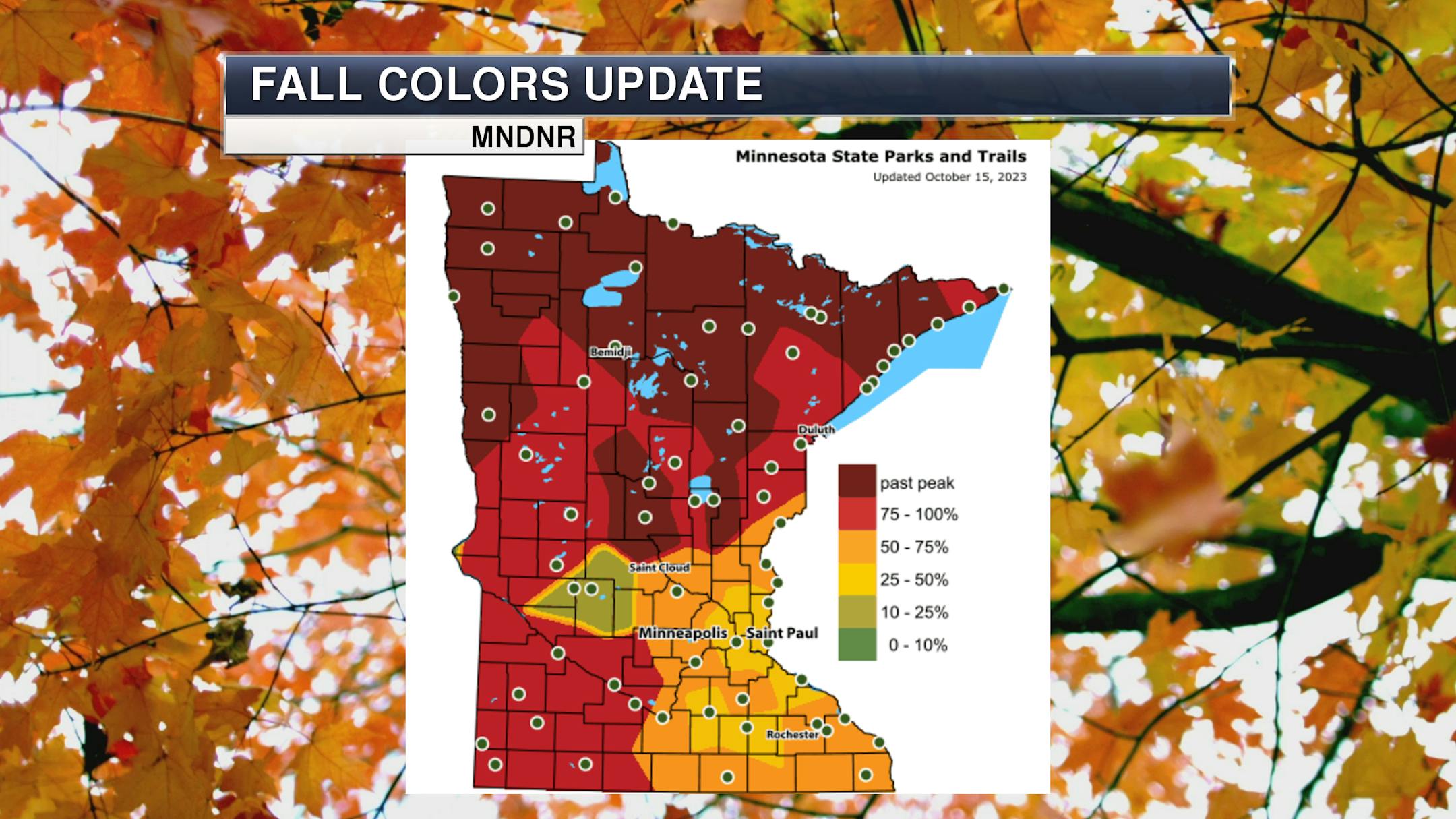
Fall colors are at or past peak across northern and western Minnesota according to the latest update from the Minnesota DNR Fall Color Finder, with leaves starting to approach peak elsewhere in the state. I would expect the rest of the state to be at or past peak within the next several days. On Saturday, Camden State Park out in southwestern Minnesota reported 75-100% color and stated that: "Maples are the star of Camden's fall color scene this week. Overall, the colors are mildly muted. Yellows and reds are looking a little brown. Some trees have lost their leaves while many cottonwoods are still looking green. Sumac on the prairie's edge is a deep red. On the prairie, a few asters remain but other flowers have lost their blooms."

_______________________________________________

Another Mix Of Sun And Clouds Monday

(The Minnesota Star Tribune)

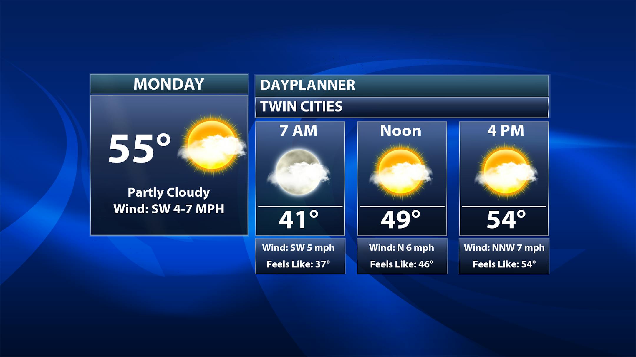
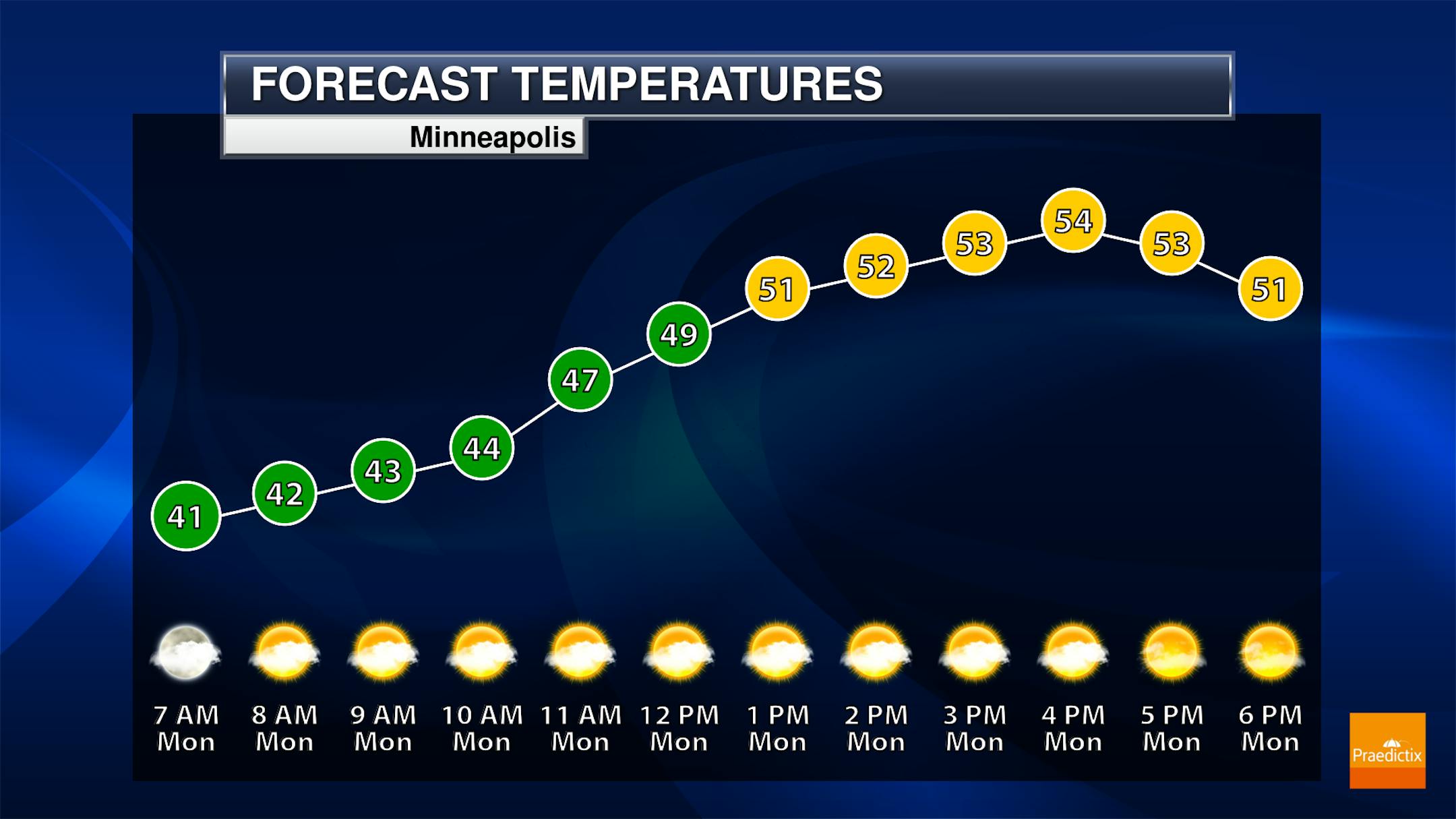
Monday will feature another mix of sun and clouds in the metro. Morning temperatures will start off around 40F with highs in the mid-50s.

(The Minnesota Star Tribune)

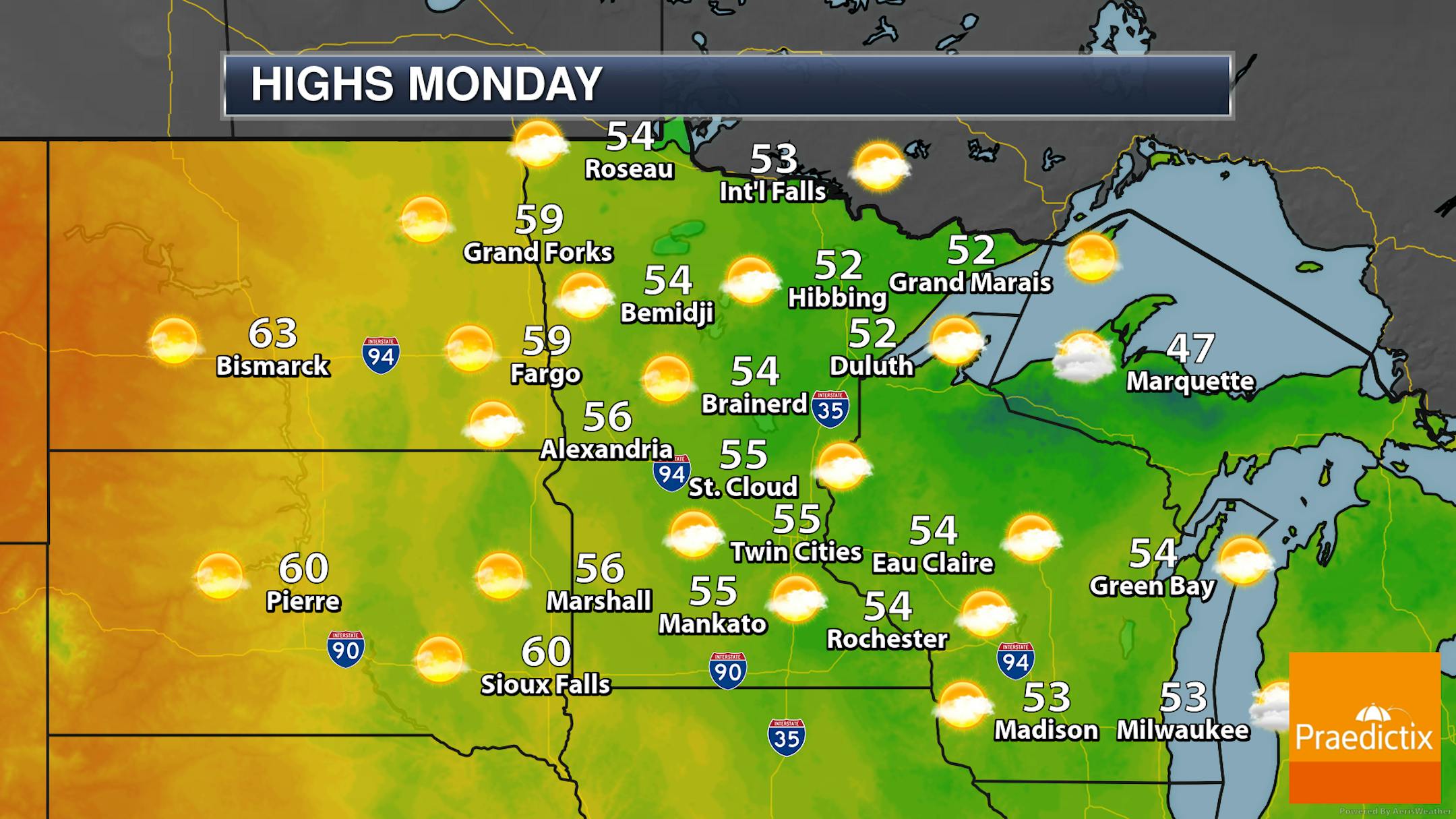
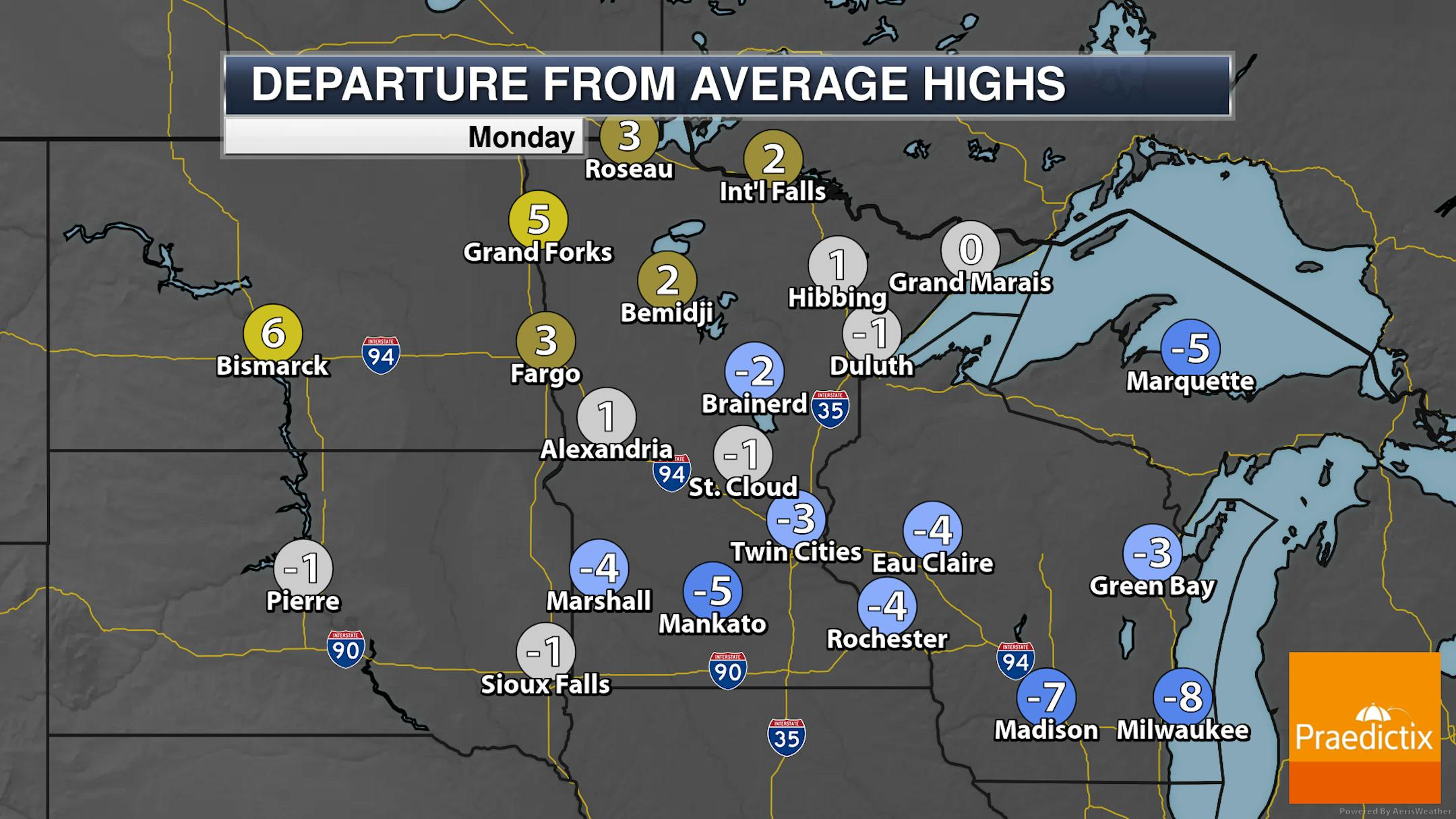
Those across the eastern half of Minnesota and into western Wisconsin will see a mix of sun and clouds (or even more clouds than sun) on Monday, with sunnier skies expected across the western half of Minnesota. Highs will generally be in the 50s across Minnesota and western Wisconsin on Monday, with a few 60s possible out by the Dakotas border where they see more of that sunshine.

_______________________________________________

Quiet Start To Week - Rain Chances Increase Wednesday/Thursday

(The Minnesota Star Tribune)

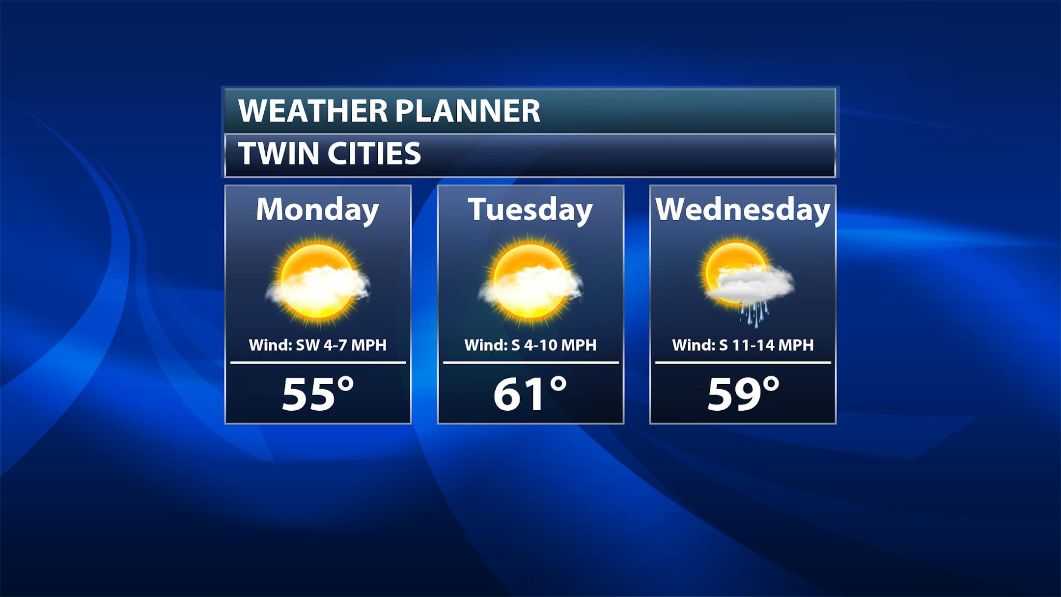
Tuesday: Quiet weather continues, but I expected an uptick in clouds late in the day as a system approaches the region. Highs climb to the low 60s.

Wednesday: We will be tracking a system moving in that will bring the potential of some scattered showers. Rainfall amounts look to be on the lighter side at the moment. Highs will climb up to around 60F once again.

(The Minnesota Star Tribune)

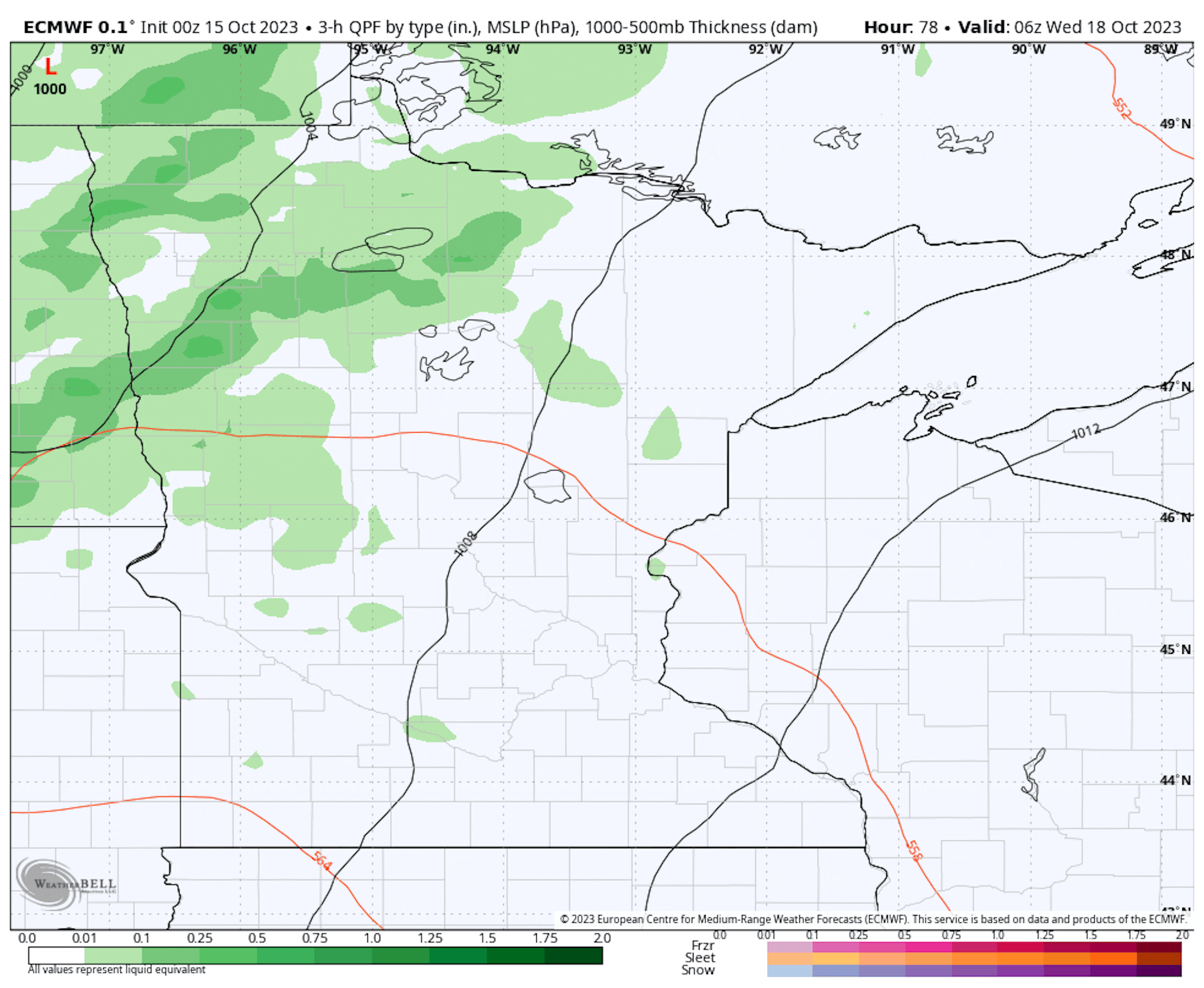
Three-hour precipitation forecast totals between 1 AM Wednesday and 7 PM Thursday.

Here's a look at that system moving into the region during the middle of the week. You can easily tell that this is not like the system that impacted us late last week - the showers will be much more scattered (and lighter) across the region. Rainfall amounts generally under a quarter inch are expected over the Wednesday-Thursday time period.

(The Minnesota Star Tribune)

Tuesday and Wednesday will be the warmest days of the extended period, climbing to around 60F or into the low 60s. Once that mid-week system moves in, highs look to taper back off to the mid-50s throughout the extended MEA weekend in the metro.

_______________________________________________

Fine Fall Weather First Half Of This Week
By Paul Douglas

Words matter, even in the verbiage meteorologists use to describe the upcoming weather. There is a stark difference between rain and showers. A forecast of "showers" implies hit or miss rain falling only some of the time, with big variations in rainfall. A prediction of "rain" implies steadier, more widespread rainfall of a longer duration. Everyone gets wet, but there can still be significant variations in amounts.

Friday's soaker was predicted days in advance but if anything, my rainfall estimates of 1-2" were too conservative. Some 3" totals were observed in the west metro. That's an average MONTH'S worth of rain in October falling in 36 hours. Wow.

The sun sputters overhead today with 60s Tuesday and Wednesday. A clipper-like system may spark a few spirited rounds of showers Wednesday into Thursday amounts in the .1 to .2" range. 50s return later this week but I see 60s, even a shot at 70F next weekend.

Good leaf-raking weather. Wait, this is finally "good sleeping weather". Good napping weather!

_______________________________________________

Paul's Extended Twin Cities Forecast

MONDAY: Partly sunny skies. Wake up 42. High 56. Chance of precipitation 0%. Wind N 8-13 mph.

TUESDAY: Plenty of sunshine, milder. Wake up 41. High 62. Chance of precipitation 0%. Wind S 8-13 mph.

WEDNESDAY: Mild with showers moving in. Wake up 50. High 63. Chance of precipitation 70%. Wind W 10-20 mph.

THURSDAY: Windy and cool with showers. Wake up 51. High 57. Chance of precipitation 70%. Wind NW 15-30 mph.

FRIDAY: Peeks of sun, cool breeze. Wake up 45. High 60. Chance of precipitation 10%. Wind NW 10-20 mph.

SATURDAY: Lukewarm sunshine. Wake up 43. High 64. Chance of precipitation 0%. Wind SE 8-13 mph.

SUNDAY: Blue sky, few complaints. Wake up 47. High 68. Chance of precipitation 10%. Wind S 10-20 mph.

_______________________________________________

Minneapolis Weather Almanac And Sun Data
October 16th

(The Minnesota Star Tribune)

*Length Of Day: 10 hours, 56 minutes, and 49 seconds
*Daylight LOST Since Yesterday: 3 minutes and 1 second

*When Do We Drop Below 10 Hours Of Sunlight? November 5th (9 hours, 59 minutes, 11 seconds)
*Latest Sunrise Before We "Fall Back": November 4th (7:55 AM)
*Earliest Sunset Before We "Fall Back": November 4th (5:57 PM)
_______________________________________________

This Day in Weather History
October 16th

1996: Early evening storms produce 3/4 to 1 3/4 inch hail in Nicollet, Dakota, Brown, Watonwan, and Martin Counties. In Scott County near St. Patrick, hail fell intermittently for an hour and the area received 3 1/2 inches of rainfall. In Watonwan County, wind gusts up to 63 mph moved several garages off their foundations, destroyed a cattle shed and a corn crib, and uprooted and toppled trees. Southwest of Lake Crystal in Blue Earth County, a garage was blown over onto a vehicle. A 250 gallon fuel tank was also blown over.

1937: A snowstorm dumps 10 inches at Bird Island.

1880: An early blizzard occurs in Minnesota. The blizzard struck western Minnesota and the eastern Dakotas especially hard. Over a foot of snow fell in western counties. Railroads were blocked, and damage was done to Great Lakes shipping.

_______________________________________________

National Weather Forecast

(The Minnesota Star Tribune)

A system moving into the Pacific Northwest Monday will bring rain and higher elevation snow chances to the region. We'll also watch scattered showers from the Mid-Atlantic to the Northeast, and still downwind of portions of the Great Lakes as well. Some snow could mix in at times in the Appalachians.

(The Minnesota Star Tribune)

Some of the heaviest rain will fall in the Pacific Northwest through the first few days of the work week, with potentially up to 3" for some locations.

(The Minnesota Star Tribune)

A few inches of snow could fall through the first part of the week in the Cascades.

_______________________________________________

The EU just kicked off its biggest climate experiment yet

More from Grist: "With little fanfare, the European Union has launched a huge climate experiment. On October 1, the EU kicked off the initial phase of a Europe-wide tax on carbon in imported goods. This marks the first time a carbon border tax has been tried at this scale anywhere in the world. Europe's experiment could have ripple effects across the entire globe, pushing high-emitting industries to clean up their production and incentivizing other countries to launch their own carbon taxes. It may well end up being the most important climate policy you have never heard of."

Rivers may not recover from drought for years

More from the University of California Riverside: "Lack of rainfall is not the only measure of drought. New UC Riverside research shows that despite a series of storms, the impact of drought can persist in streams and rivers for up to 3.5 years. There are two measures of drought in streams. One measure is the total water level, which is impacted by snowmelt and rainfall. Many researchers examine this measurement. Another measure is baseflow, which is the portion of streamflow fed by groundwater."

Research shows wildfire smoke may linger in homes long after initial blaze

More from Colorado State University: "Newly published research on indoor air quality from Colorado State University shows wildfire smoke may linger in homes long after the initial blaze has been put out or winds have shifted. The findings, published in Science Advances, show that wildfire smoke can attach to home surfaces like carpet, drapes or counters – extending the exposure for those inside and potentially causing health problems even after an initial cleaning activity by air purifiers. However, Professor Delphine Farmer said the research also shows that simple surface cleaning – like vacuuming, dusting or mopping – can reduce exposure and limit risk."

_______________________________________________

Follow me on:

Thanks for checking in and have a great day!

- D.J. Kayser

(The Minnesota Star Tribune)
about the writer

about the writer

D.J. Kayser

See Moreicon