Perseid meteor shower Peaks This Weekend

"When, where & how to see it - The Perseid meteor shower is one of the best shooting star displays of the year and it's currently active. The Perseid meteor shower (also known as the Perseids) is active every year from mid-July to late August. This year the shower will peak around Aug. 13, 2023, according to skywatching site In The Sky, 2023 will be a good year for the Perseids as the moon will only be 10% illuminated. The Perseids are caused by Earth passing through debris — bits of ice and rock — left behind by Comet Swift-Tuttle which last passed close to Earth in 1992. The Perseids peak when Earth passes through the densest and dustiest area on Aug. 11-12. Years without moonlight see higher rates of meteors per hour, and in outburst years (such as in 2016) the rate can be between 150-200 meteors an hour. On average, you can expect to see up to 100 meteors per hour during the Perseid's peak, according to NASA. In 2022, the Perseids were affected by the full moon illuminating the sky and washing out fainter meteors. However, this year the moon will provide minimal disturbance to the meteor shower as it will only be 10% illuminated during the time of the peak."

A Few Showers Midweek

The simulated radar from AM Tuesday to PM Wednesday shows dry conditions through much of the day Tuesday. By Wednesday, a line of t-showers will drift through the northern half of the state. Rainfall tallies should be mainly light, but there could be a few pockets of heavy amounts here and there.

Rainfall Potential Through Early Next Week

Here's the rainfall outlook through early next week, which shows somewhat soggy weather across the southern half of the state. Some spots could see close to 1.00" of rain or more.

11th Driest Meteorological Summer on Record

It has been very dry across much of the region so far this summer with only 3.85" of rain falling at the MSP Airport since June 1st. That is -5.65" below average and is the 11th driest Meteorological Summer on record with the driest being 1.35" set in 1894. Interestingly, the last two summers (2022 & 2021) were even drier than this one.

9th Hottest Meteorological Summer on Record

It has also been a hot summer with readings running well above average since June 1st and good enough for the 9th hottest Meteorological Summer on record so far. Note that 2021 was the 3rd hottest and 2022 was the 9th hottest From June 1st to August 6th. With that being said, the last 3 summers have been pretty warm and dry.

60 Day Precipitation Anomaly

The map below shows the 60 day precipitation anomaly, which indicates that some locations are nearly -3.00" to nearly -6.00" below average (in red/pink) since early June. There are a few locations across the state that have surpluses, but most locations are well below average.
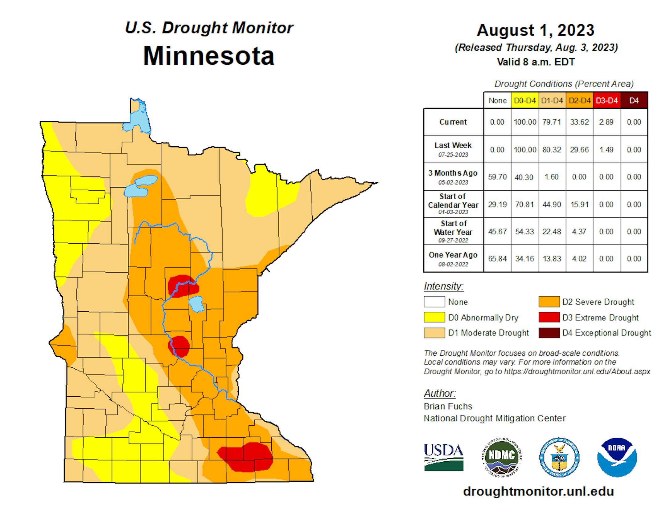
Drought Update

Drought conditions continue to deepen across the region with a few pockets of Extreme Drought showing up (in red). The last time that parts of Minnesota were in an Extreme Drought was back in mid December, nearly 7 months ago.

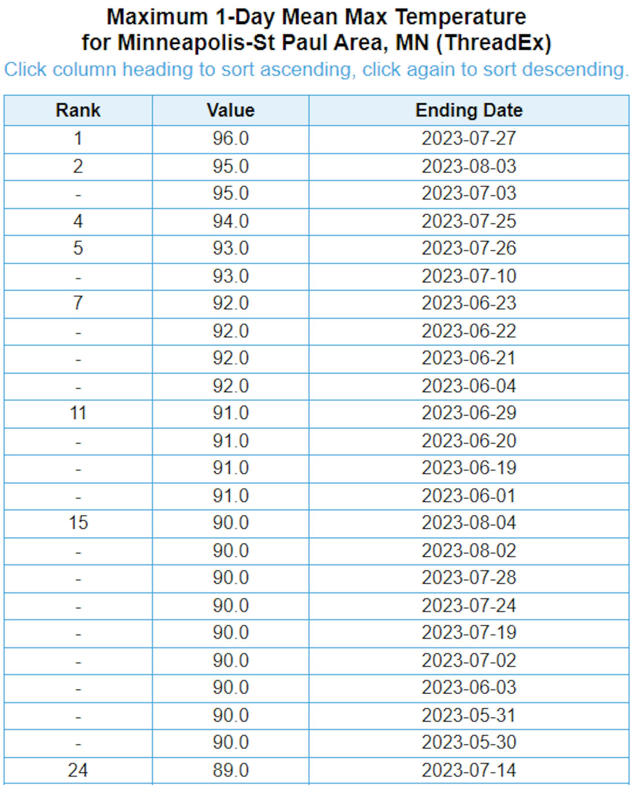
Hottest Days of 2023 So Far

The hottest day of 2023 (so far) was Thursday, July 27th with a high of 96F and heat index values peaking around 105F to 110F. Uffda! There have been (23) 90F days this year. Our average number of 90F days is 14.

Average Number of 90F Days At MSP

Looking at the last 30 years, the average number of 90F days at the MSP Airport is (14). July is the hottest month with an average of (6) 90F days. This year we've had (23) 90F days, last year we had (18) days in the 90s and in 2021 there were (27) days in the 90s. The most number of 90F days in any single year was (44) set in 1988.

Twin Cities Weather Outlook For Tuesday

The weather outlook for the Twin Cities on Tuesday, August 8th will be mild with temps warming into the mid 80s, which will be slightly above average for this time of the year. Skies will be sunny westerly winds through the day.

Meteograms For Minneapolis

The hourly temps through the day Tuesday shows readings starting in the mid 60s and only warming into the mid 80s, which will be a little above average for this time of the year. No weather drama is expected with bright, sunny skies and westerly winds approaching 15mph in the afternoon.

Weather Outlook For Sunday

Temps on Sunday will generally warm into the 80s across the state, which will be a little above average for early August. Much of the state will be dry and sunny, but late day showers and storms will be possible across the northwestern corner of the state with locally heavy rainfall.

Extended Temperature Outlook For Minneapolis

The 5 day temperature outlook for Minneapolis shows temps only warming into the mid 80s through Thursday, which will be at or slightly above average for early/mid August. We'll cool down slightly as we approach the weekend with readings into the upper 70s. The dewpoints will also be a bit lower, so it'll feel a little more comfortable with hints of September.

Stickier Dewpoints Into the Week Ahead

Dewpoints on Tuesday will more comfortable with readings generally in the 50s before rising slowly into the low/mid 60s, which will be kinda sticky once again. By the weekend, temperatures and dewpoint values will drop back to more comfy levels.

Extended Weather Outlook For Minneapolis

The extended weather outlook for the Twin Cities doesn't show anything too wild as we slide through mid-month. No big heat spikes in the immediate future either with temps hovering close to and slightly above average through the weekend ahead. There will be a few chances of rain Tuesday night into early Wednesday and once again Thursday night into early Friday. Let it rain!

Extended Temperature Outlook For Minneapolis

The extended temperature outlook for Minneapolis through mid-August doesn't show any major heat waves setting up. It'll be a little warmer than average this week, but the overall trend shows readings hovering around and into the low/mid 80s into the 3rd week of the month.

Weather Outlook

The National Weather Outlook through the week ahead looks a little more unsettled across the Midwest with a few storms systems moving through over the next 7 to 10 days. T-Showers will be possible midweek with better chances of rain closer to the International border.

8 to 14 Day Temperature Outlook

According to NOAA's Climate Prediction Center, the 8 to 14-day temperature outlook shows cooler than average temps lingering across parts of the High Plains and the Midwest. However, warmer than average readings will continue across much of the rest of the nation and especially in the Western US and along the Southern US.

8 to 14 Day Precipitation Outlook

The extended precipitation outlook shows suggest more active weather possibly along and east of the Mississippi River Valley. Drier weather appears to be developing across the Pacific Northwest as the heat settles in.

Seasonably Warm With Late Week T-Showers
By Paul Douglas

After the big weekend weather bust (heavy rain tracking farther south) a friend and frustrated fellow-meteorologist reached out. "What people need to understand is that meteorology is not an exact science, like foreign policy, military strategy, stock-picking and fantasy football." Very true. Good luck predicting the future. It rarely turns out precisely the way you think it will.

It may be a sign of progress. Meteorologists are in the ballpark most of the time, so when we do mess up big-time it's somehow shocking and newsworthy. No matter how good the weather models or data initialization gets, forecasts will never be perfect, 100% of the time. With any luck we won't miss any floods, blizzards and (big) tornadoes.

I see mostly 80s into Friday with warm sunshine on tap today. A series of Alberta Clippers will sweep bands of showers and T-storms across the state, with the best chance of (a little) rain Thursday night into Friday.

No 90s in sight, just a fine spell of "normal weather". What's that?

Extended Forecast

TUESDAY: Warm, smoky sunshine. Winds: W 8-13. High 86.

TUESDAY NIGHT: Mostly clear and quiet. Winds: SW 5-10. Low: 65.

WEDNESDAY: Fading sun, late PM T-storm? Winds: SW 8-13. High: 85.

THURSDAY: Sunny much of the day. Storms at night. Winds: S 8-13. Wake-up: 64. High 84.

FRIDAY: Showers and T-storms in the area. Winds: W 10-20. Wake-up: 68. High 81.

SATURDAY: Some sun, breezy, less humid. Winds: NW 15-25. Wake-up: 65. High: 80.

SUNDAY: Intervals of sun, hints of fall. Winds: NW 10-20. Wake-up: 61. High: 79.

MONDAY: Sunny and warmer. Winds: S 10-20. Wake-up: 60. High: 83.

This Day in Weather History

August 8th

1930: A record high of 102 is set at Redwood Falls.

Average High/Low for Minneapolis

August 8th

Average High: 82F (Record: 96F set in 1894, 1914 & 2010)

Average Low: 64F (Record: 47F set in 1888)

Record Rainfall: 2.22" set in 1987

Record Snowfall: NONE

Sunrise/Sunset Times for Minneapolis

August 8th

Sunrise: 6:06am

Sunset: 8:30pm

Hours of Daylight: ~14 hours & 23 minutes

Daylight LOST since yesterday: 2 Minutes & 36 Seconds

Daylight LOST since Summer Solstice (June 21st): ~ 1 Hour & 13 Minutes

Moon Phase for August 8th at Midnight

See more from Space.com HERE:

National High Temps on Tuesday

Temperatures on Tuesday will still be well above average across the Southern US with widespread record heat across Texas. It'll be a little cooler through the Intermountain-West with highs warming into the 70s and 80s.

National Weather Tuesday

The weather outlook on Tuesday will feature showers and storms across parts of the Central US and down into the Southeast. Some of the storms could be strong to severe with locally heavy rainfall. There will also be additional storms in the Northeast, some of which could be strong as well.

National Weather Outlook

The weather outlook through Wednesday shows lingering strong to severe storms in the Northeast with locally heavy rainfall. There will also be a few areas in the Central US that could see vigorous storms and heavy rain.

Extended Precipitation Outlook

According to NOAA's Weather Prediction Center, the extended precipitation outlook shows heavier rain potential across parts of the Central and Eastern US, where localized flooding can't be ruled out. A few monsoonal thunderstorms will be possible in the Southwest, but much of the West Coast will remain dry.

Climate Stories

"FEMA Disaster Relief Fund set to run out of money as busy part of hurricane season approaches"

"While the busy part of hurricane season is approaching, the government said the money it uses to help communities recover from disasters could run out this month. When any major disaster strikes, it's all hands-on deck. That includes FEMA coming into communities across the country. It's a situation former emergency manager Jonathan Gaddy knows well. Gaddy is now with the International Association of Emergency Managers. He explained FEMA's primary role in the long term is as a check book to reimburse local authorities. "We don't carry insurance on things like our public infrastructure, our roads and our bridges," he said. "These communities have limited capacity to absorb those impacts."

See more from WPXI HERE:

Why Does Rain Smell?

"My college-aged daughter called me odd the other day. She said it was not meant to be an insult. One of the things she mentioned was my quirky aversion to things like mustard, mayonnaise, and salad dressings. I am sure my sensitivity to smells qualifies me for her odd designation too. On rainy days, I often smell the rain. I bet many of you often smell rain too. The "smell" of rain is called petrichor. Here's what you need to know about it. Though petrichor is the used to describe the scent of rain, the smell actually describes oils and chemicals released from the ground. As I previously wrote, "The basic chemistry of the process is related to decomposed organic material fused with soil, rock, and minerals in an interesting chemical brew." The word is derived from two Greek words - "petra" (stones of the Earth) and "ichor" (a mythological term related to the blood of the gods)."

See more from Forbes HERE:

"Iceland's newest volcano is now spewing out tornadoes"

"Iceland's newborn volcano is announcing its arrival with a bang, spewing out methane explosions and tornadoes to complement the ribbons of lava painting the landscape. Loud bangs echoed from the eruption site on the Reykjanes Peninsula, the Icelandic Met Office reported on July 27, indicating that pockets of methane gas trapped in the lava flow are exploding. As if that wasn't explosive enough, Earth's newest "baby volcano" triggered a whirling tornado, which can be seen rising into the sky in a YouTube video posted on July 24. Litli-Hrútur, or "Little Ram," was born via a fissure that fractured the ground on July 10 and has been spewing rivers of lava ever since. "When lava flows over a vegetated area, methane gas can be produced when the vegetation does not burn completely," the Icelandic Met Office said in a translated Facebook post. "The gas then accumulates in gaps and cavities in the lava."

See more from Live Science HERE:

Thanks for checking in and don't forget to follow me on Twitter @TNelsonWX