Over A Foot Of Snow Reported

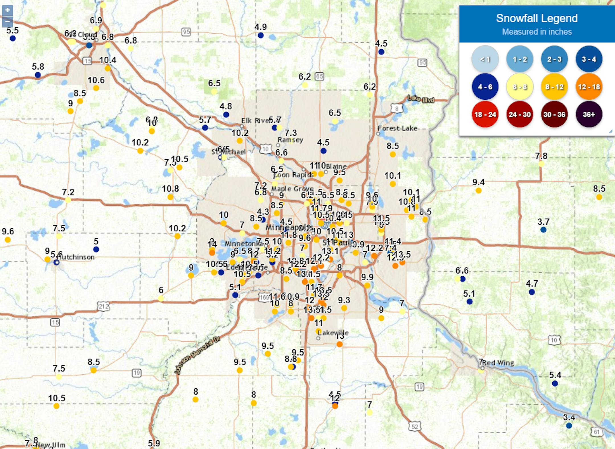
The snow has quickly piled up out there since Tuesday with over a foot of snow reported in some parts of the metro. The highest total - 14" - was reported near Mound. As of Noon Wednesday, MSP had reported 12.2" of snow.

_______________________________________________

Record Precipitation Tuesday

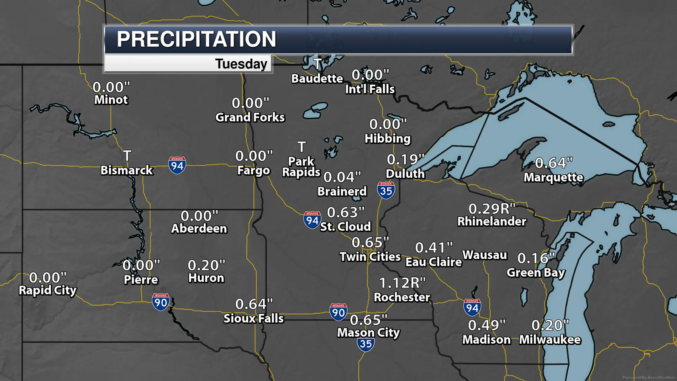
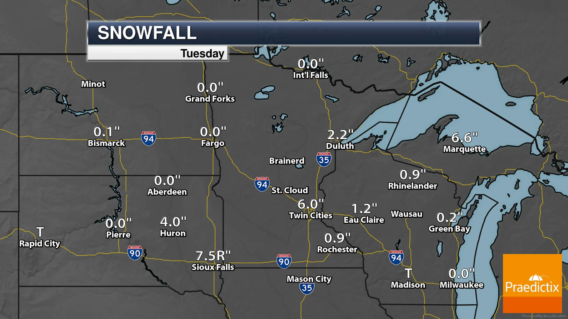
This system on Tuesday brought record precipitation to the region. The 7.5" of snow that fell in Sioux Falls was a record. Meanwhile, over an inch of liquid was reported in Rochester, setting a record there.

_______________________________________________

Snow Tapers Off Early Thursday

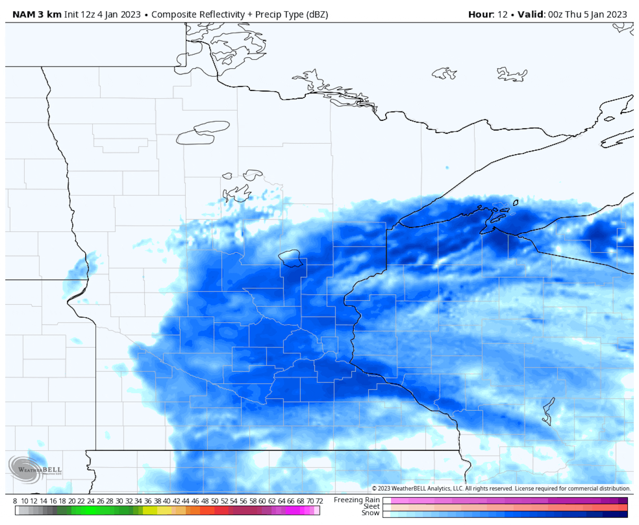
Forecast loop from 6 PM Wednesday to Noon Thursday.

And the snow potential continues across the southern two-thirds of the state as we head into Wednesday evening. However, the system responsible is heading off to the east, which means the snow will finally start to taper off through the overnight hours. A few snowflakes may remain into the morning rush in eastern Minnesota, but by midday Thursday snow should be over.

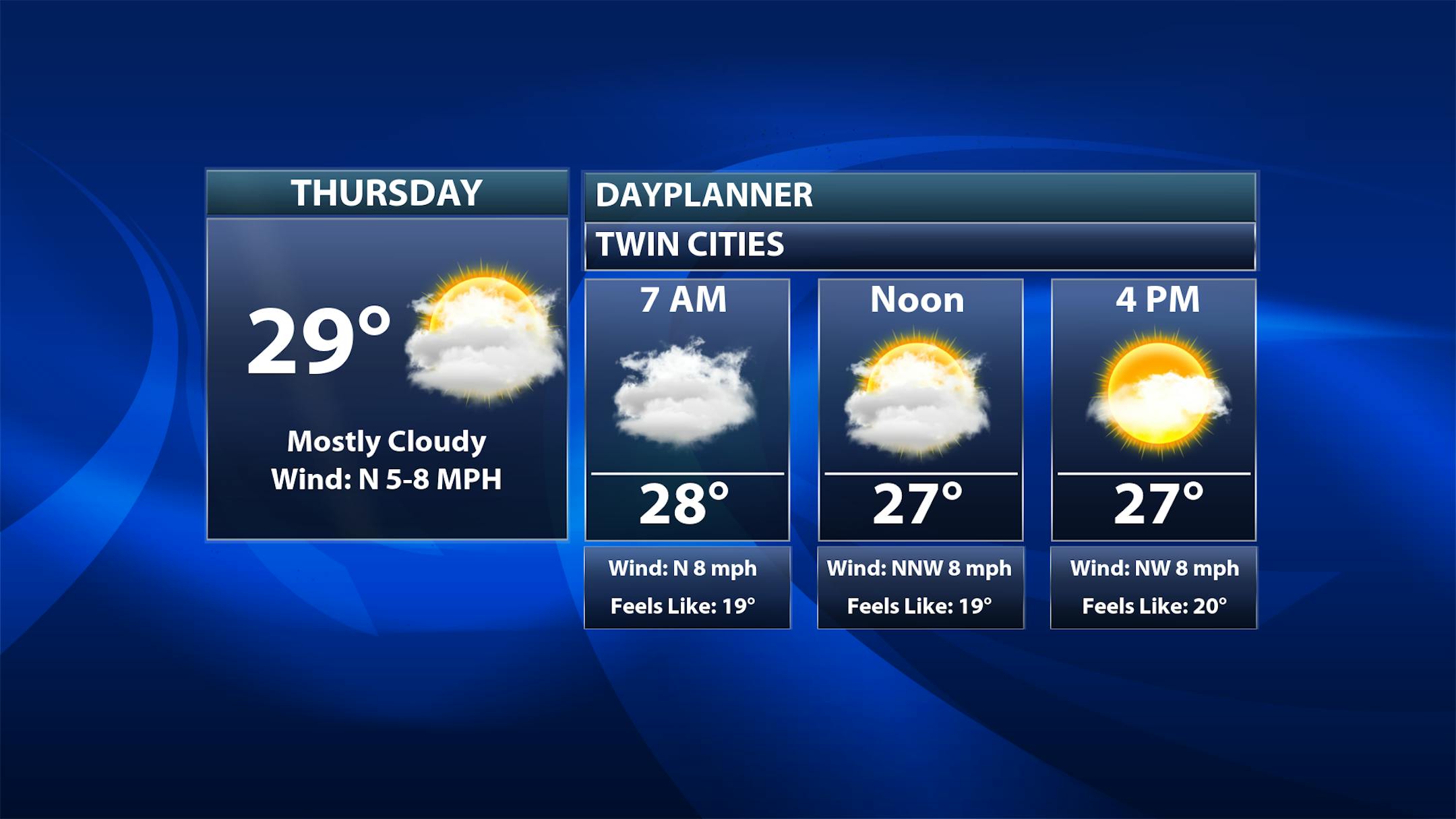
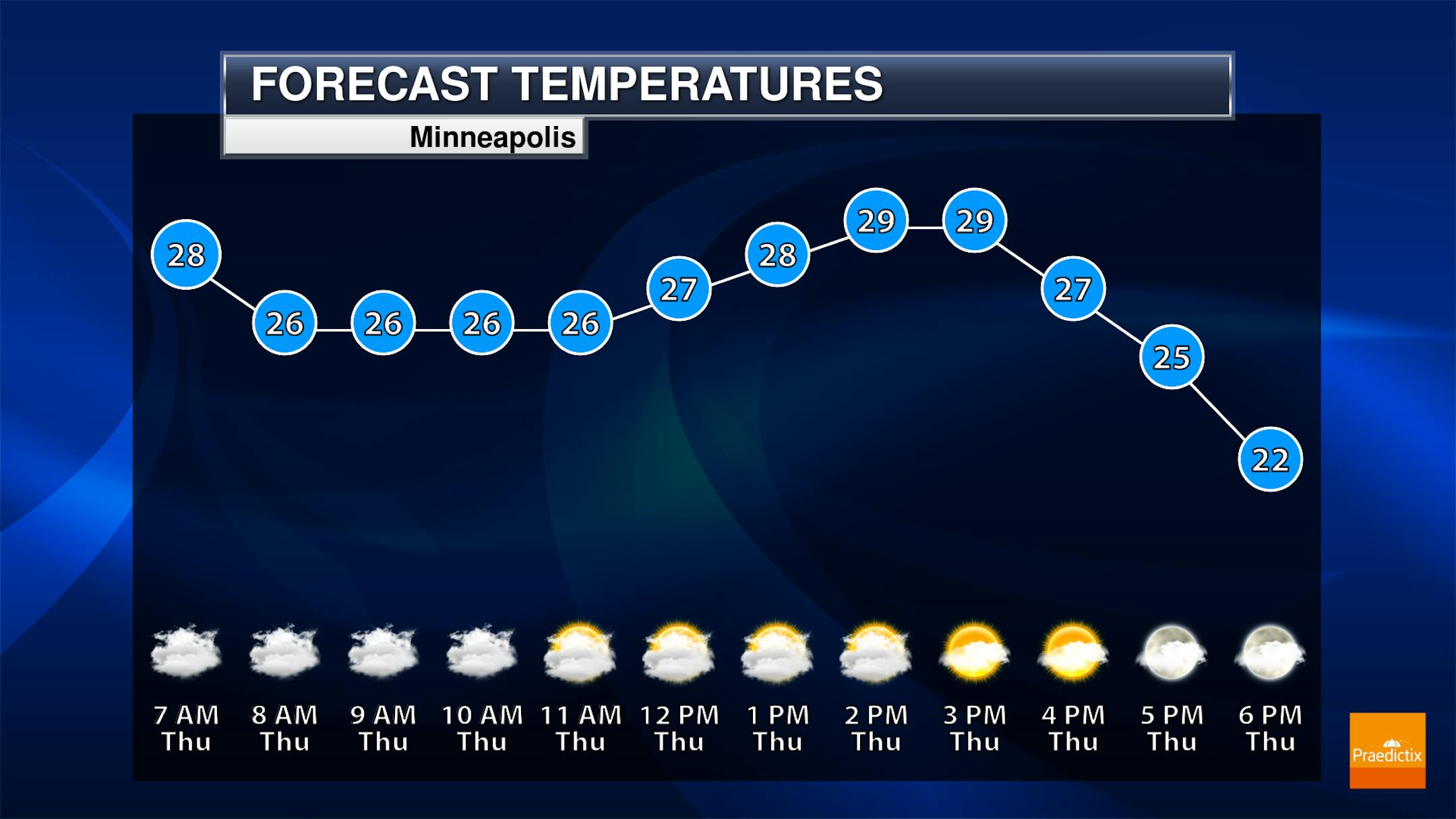
So while there could be a lingering snowflake around Thursday morning, the good news is that the storm is heading out of here! Skies remain mostly cloudy throughout much of the day, but there should be some more peeks of sun in the afternoon hours. Temperatures will stay pretty steady in the mid to upper 20s throughout the day.

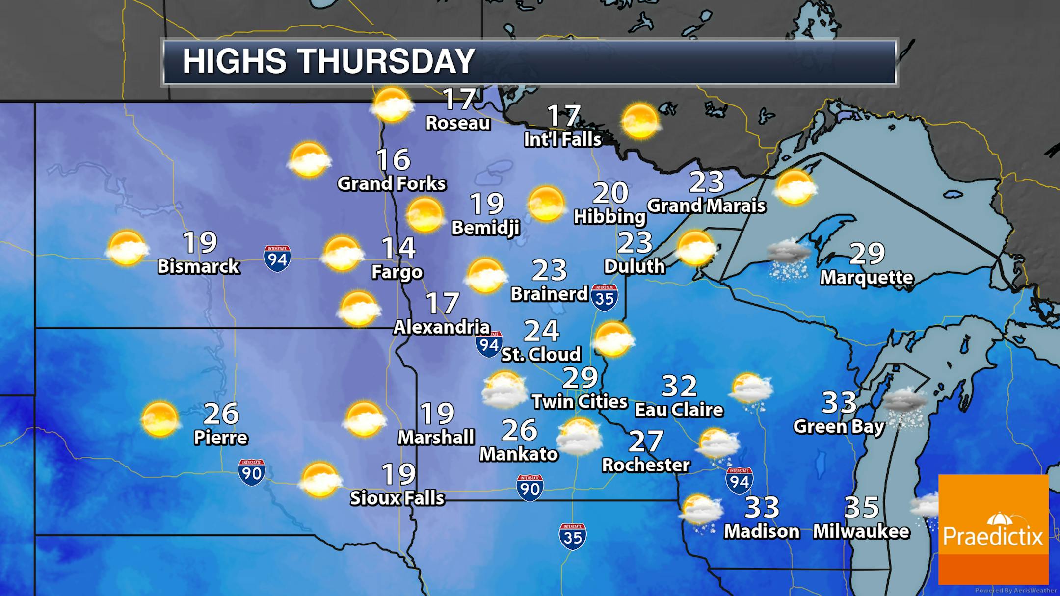
So we'll push that snow eastward heading into the day Thursday with a mix of sun and clouds across the state (more clouds than sun across northwestern and southeastern Minnesota, with more sun than clouds elsewhere). Highs will be in the teens across western and northern Minnesota with 20s elsewhere.

_______________________________________________

Cool But Quiet Weekend

After our mid-week storm, we are watching quieter and sunnier weather heading into the weekend. The main thing is that it'll be cooler than we have been - highs only in the teens and low 20s. But at least we won't be having to track snow... and, in fact, we won't be really tracking snow chances until the middle of next week.

_______________________________________________

Is Mild Bias In January An El Nino Signal?
By Paul Douglas

A foot of snow in the metro? Yes please. We're in a drought and we like water in our lakes, so we'll try not to whine about our commutes. We usually get less than the weather models predict, but in this case my 6-10" prediction for the Twin Cities was too conservative. There is 1-3" of water locked up in all that icy snow!

I see a potential for accumulating snow a week from today, as a parade of gently used Pacific storms cross the Rockies, tapping moisture from the Gulf of Mexico.

I may be reading too much into the conga-line of storms pounding California with flooding rains in recent weeks; the "atmospheric river" or "Pineapple Express" shooting a firehose of moisture at the west coast. The pattern looks suspiciously like what you would expect to see during an El Nino warming phase of the Pacific, which correlates with milder winters in Minnesota. Models predict 30s in mid-January, but maybe this is all a cosmic coincidence.

It's safe to shovel now and romp in the perfect Minnesota Powder this weekend!

_______________________________________________

Paul's Extended Twin Cities Forecast

THURSDAY: Flurries finally taper. Wake up 25. High 28. Chance of precipitation 50%. Wind NW 8-13 mph.

FRIDAY: Glimmers of chilled sunshine. Wake up 9. High 16. Chance of precipitation 10%. Wind NW 5-10 mph.

SATURDAY: More sunshine, chilly. Wake up 2. High 17. Chance of precipitation 0%. Wind N 3-8 mph.

SUNDAY: Mix of clouds and sunshine. Wake up 0. High 21. Chance of precipitation 10%. Wind SW 5-10 mph.

MONDAY: Plenty of sunshine, milder. Wake up 19. High 31. Chance of precipitation 10%. Wind SW 5-10 mph.

TUESDAY: Patchy clouds, cooler breeze. Wake up 20. High 26. Chance of precipitation 10%. Wind NW 8-13 mph.

WEDNESDAY: Chance of light snow. Wake up 21. High 24. Chance of precipitation 50%. Wind E 10-20 mph.

_______________________________________________

Minneapolis Weather Almanac And Sun Data
January 5th

*Length Of Day: 8 hours, 54 minutes, and 56 seconds
*Daylight GAINED Since Yesterday: 1 minute and 7 seconds

*When do we see 9 Hours of Daylight?: January 9th (9 hours, 0 minutes, 8 seconds)
*Latest Sunrise: December 30th-January 5th (7:51 AM)
*When is Sunset at/after 5 PM?: January 17th (5:00 PM)

_______________________________________________

This Day in Weather History
January 5th

2012: Record warmth is felt across the state. Many locations in western Minnesota soared over 50 degrees, with temperatures reaching the 60s at Marshall, Canby, and Madison. This was the first record of any 60 degree temperatures in Minnesota during the first week of January.

_______________________________________________

National Weather Forecast

The west coast will continue to get blasted by an atmospheric river as we head into Thursday. While there could be widespread rain and snow, the highest concentrated totals will be in California. Meanwhile, the system that has been bringing heavy snow to the upper Midwest continues to move into the Great Lakes and Northeast, with snow, rain, and ice chances. Storms will be possible along the trailing cold front into Florida.

Heavy rain and snow will blast California through the end of the week - more on that below. We'll also see heavier snow of potentially 6"+ in parts of the Great Lakes.

Widespread rainfall amounts of at least 2-5" are expected near and along the California coast as we head through this next heavy rain event, including in the Bay Area and around Los Angeles.

  • In coastal areas, isolated totals up to 8" are expected. Especially across the Bay Area and in northern California - in areas that were blasted by the last atmospheric river plume last weekend - soils are already saturated.
  • This means that we will likely see widespread flooding impacts across the region, including rivers, creeks, streams, other low-lying/flood-prone areas, and (in urban areas) extensive street flooding. There will also be the threat for landslides.

_______________________________________________

How Climate Change Is Shaping California's Winter Storms

More from the New York Times: "Drenching rains forecast to pummel California on Wednesday and again over the weekend are poised to be the third and fourth major storms to march through in less than two weeks, raising the prospect of more misery in a season that has already brought flooding, debris flows and power outages to parts of the state. Over the weekend, rescuers scoured rural areas of Sacramento County looking for people trapped in homes or cars. Levees failed near the Cosumnes River and flooded a highway. Winter rain and snow typically provide much of the water used throughout the year in California, which has suffered several years of punishing drought. But when these storms, which are known as atmospheric rivers, are particularly severe or sweep through in rapid succession, they can do more harm than good, delivering too much water, too quickly, for the state's reservoirs and emergency responders to handle."

European weather: Winter heat records smashed all over continent

More from the BBC: "Temperatures for January have reached an all-time high in a number of nations across Europe. National records have fallen in eight countries - and regional records in another three. Warsaw, Poland, saw 18.9C (66F) on Sunday while Bilbao, Spain, was 25.1C - more than 10C above average. The mild European weather comes as North America faces more severe storms, days after a deadly winter cold snap left more than 60 dead. Heavy snow and freezing rain have been forecast for parts of the northern Midwest while severe thunderstorms and tornadoes are expected in Texas, Oklahoma, Arkansas and Louisiana. But on the European side of the Atlantic, the weather has been balmy for many places at the start of the year. Temperatures in the Netherlands, Liechtenstein, Lithuania, Latvia, Czech Republic, Poland, Denmark and Belarus broke national records. Station records were broken in Germany, France and Ukraine."

A new EPA proposal is reigniting a debate about what counts as 'renewable'

More from Grist: "The U.S. Environmental Protection Agency has proposed new standards for how much of the nation's fuel supply should come from renewable sources. The proposal, released last month, calls for an increase in the mandatory requirements set forth by the federal Renewable Fuel Standard, or RFS. The program, created in 2005, dictates how much renewable fuels — products like corn-based ethanol, manure-based biogas, and wood pellets — are used to reduce the use of petroleum-based transportation fuel, heating oil, or jet fuel and cut greenhouse gas emissions. The new requirements have sparked a heated debate between industry leaders, who say the recent proposal will help stabilize the market in the coming years, and green groups, which argue that the favored fuels come at steep environmental costs."

_______________________________________________

Follow me on:

Thanks for checking in and have a great day!

- D.J. Kayser