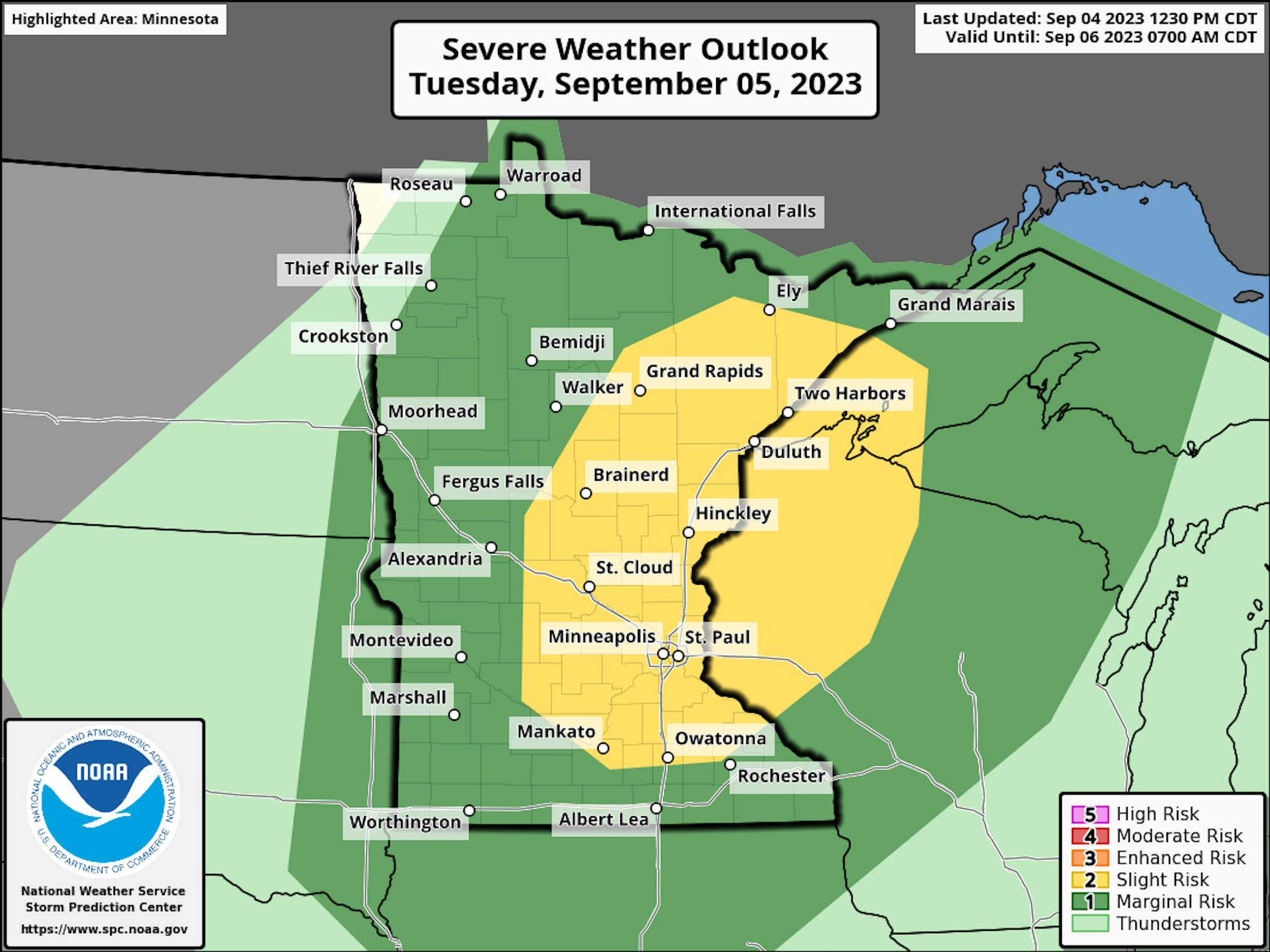
Severe Threat on Tuesday

According to NOAA's Storm Prediction Center, there is a Slight Risk of severe storms on Tuesday with gusty winds and large hail as the primary concerns, but an isolated tornado can't be ruled out.

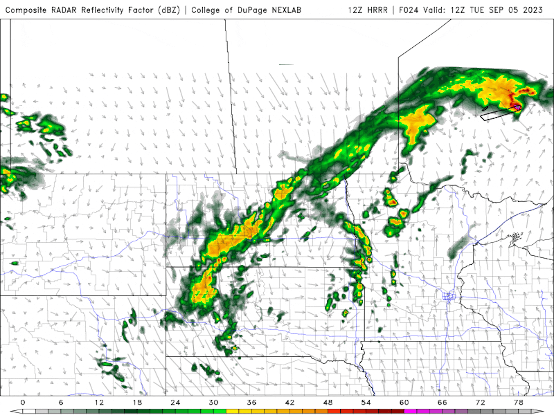
Simulated Radar For Tuesday

This is the simulated radar from AM Tuesday to AM Wednesday. It looks like the best potential for strong to severe storms arrives later in the day, mainly after 5pm. Storms will linger through the early morning hours of Wednesday before things dry out.
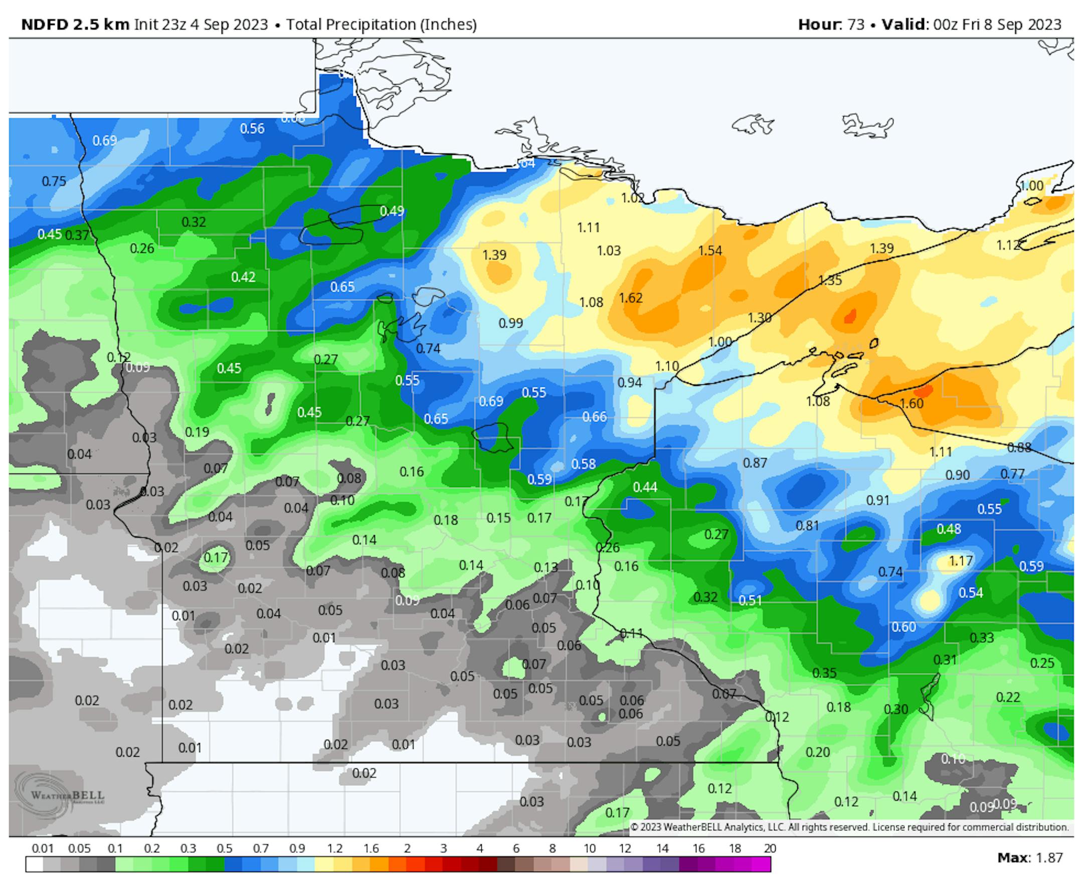
Rainfall Potential

Areas of heavy rain will be possible across parts of the region through midweek. The heaviest amounts will be found in the Northeastern part of the state with some 1" to 1.5" amounts possible. The Twin Cities could see 0.25" to 0.50" amounts, while folks in Southwestern Minnesota might not see anything.

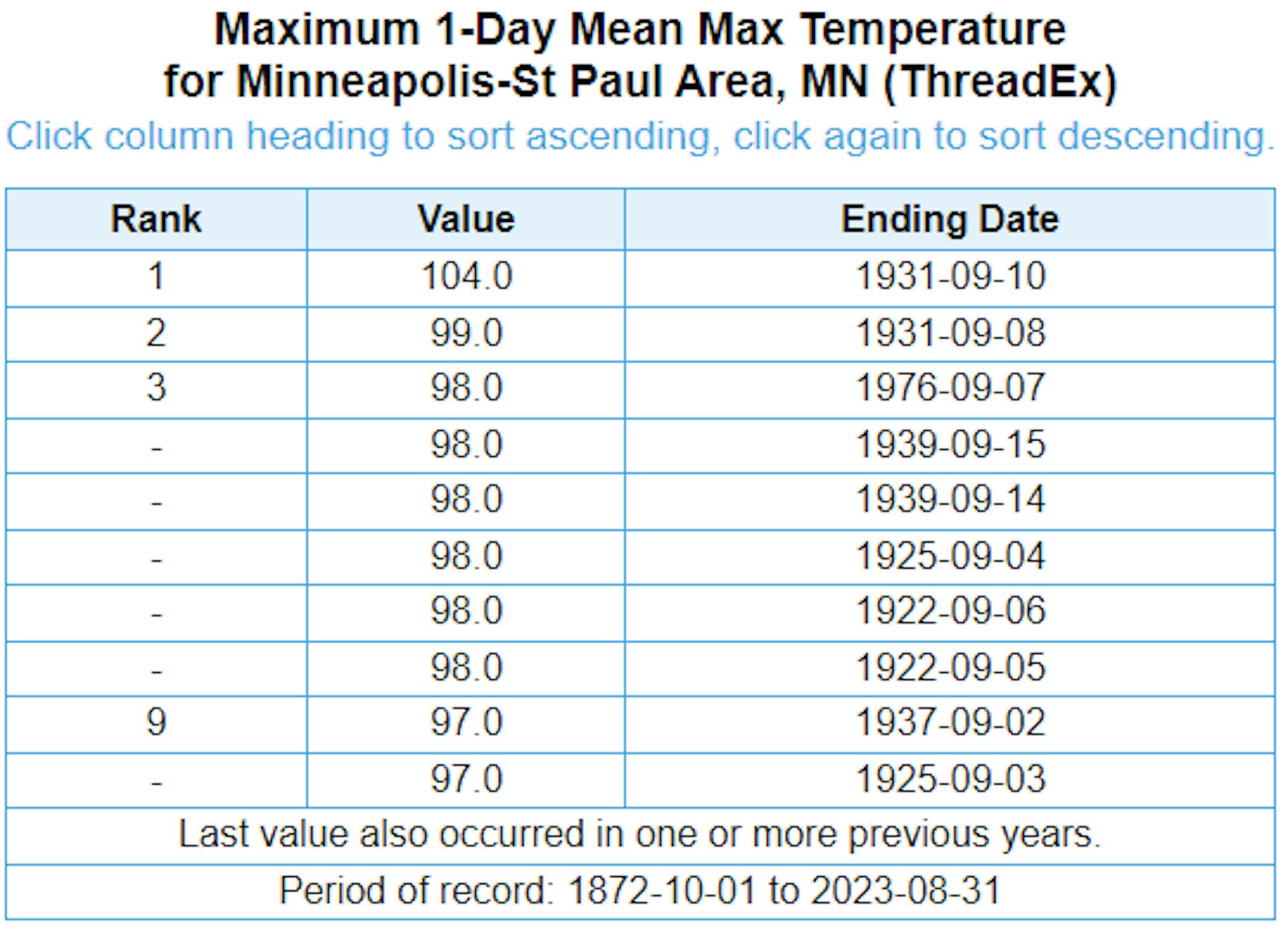
Hottest MSP Temps Ever Recorded in September

Here are the top 10 highest temperatures ever recorded in Minneapolis during the month of September. If we hit 100F this weekend, it would only the be the 2nd time that has ever happened. Regardless, we have at least a couple of chances of cracking the top 10 highest temps this weekend.

Number of 90F Days So Far This Year

The hottest days of 2023 (so far) were back to back on August 22nd and 23rd, when the MSP hit 98F and heat index values peaking around 110F to 120F around the metro. Uffda! Through Monday, September 4th, there have been (31) 90F days this year and tied for the 13th most number of 90F days in any year. The extended outlook brings us back into the 90s for the Labor day weekend, so we'll continue to add to that tally.

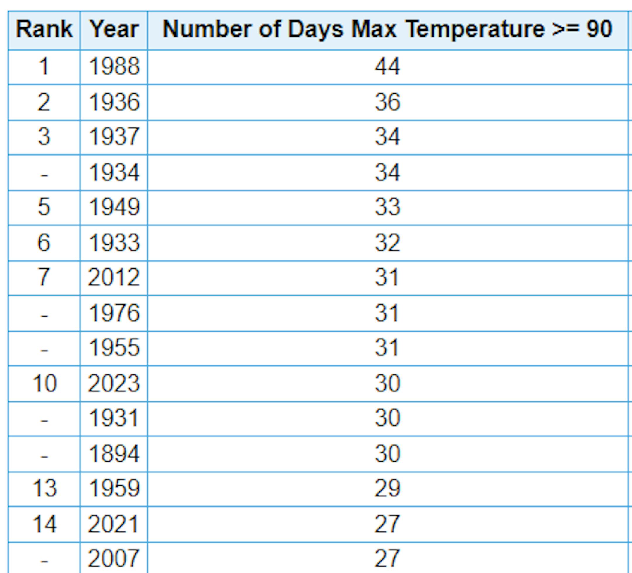
Average Number of 90F Days At MSP

Looking at the last 30 years, the average number of 90F days at the MSP Airport is (14). July is the hottest month with an average of (6) 90F days. This year we've had (23) 90F days, last year we had (18) days in the 90s and in 2021 there were (27) days in the 90s. The most number of 90F days in any single year was (44) set in 1988.

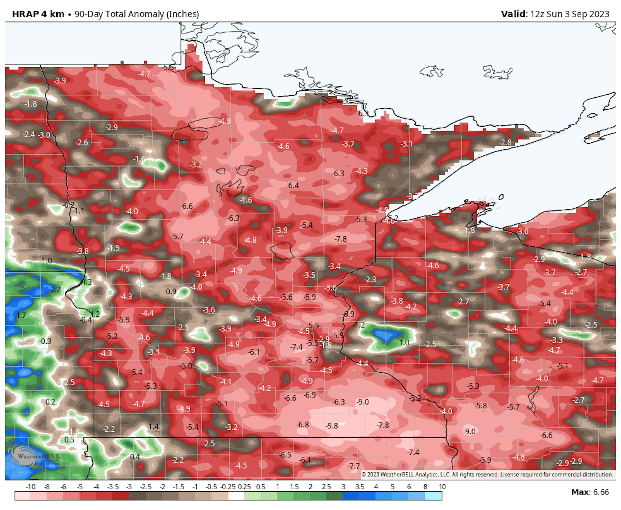
90 Day Precipitation Anomaly

On average, the wettest time of the year is in the summer, with the months of June, July and August seeing nearly 13" of rain at the MSP Airport. If we take a look at the 90 day precipitation anomaly, which dates back to early June, some locations are nearly -3.00" to nearly -7.00" below average (in red/pink). Note that some locations across southeastern Minnesota are nearly -8.00" to -10.00" below average.
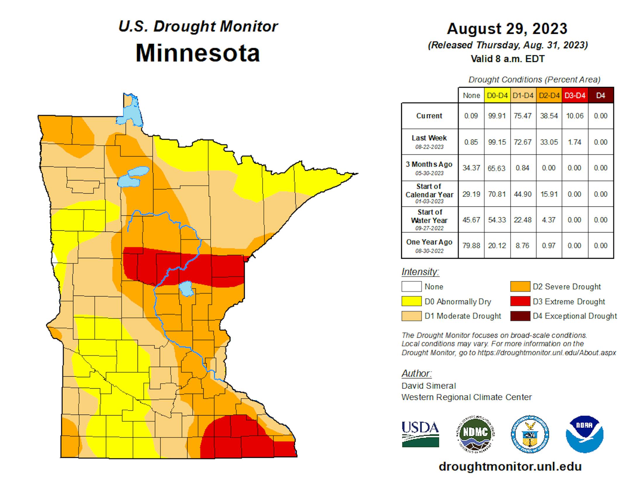
Drought Update

Drought continues and expanded from last week with nearly 10% of the state now in an Extreme Drought. Severe Drought is now almost 40% and includes much of the Twin Cities metro. 3 months ago, 65% of the state was considered just abnormally dry.

Twin Cities Weather Outlook For Tuesday

The weather outlook for the Twin Cities on Tuesday, September 5th will be hot and humid with temperatures warming into the 90s once again. With dewpoints in the upper 60s to near 70F, it'll feel like the upper 90s. There will also be thunderstorms in the afternoon and evening, some of which could be strong to severe.

Meteograms For Minneapolis

Weather conditions for Minneapolis through the day Tuesday will be hot and sticky with temps starting in the 70s in the morning and warming into the low/mid 90s in the afternoon. Feels like temps will warm into the upper 90s later in the day with gusty south winds around 25mph.

Weather Outlook For Tuesday

Temps on Tuesday will warm into the 80s and 90s across the state, which will be nearly 10F to 20F above average for early September. These warm temps will be ahead of a cool front that will be responsible for scattered showers and storms later in the day. Note that temperatures across the Dakotas will only warm into the 60s and 70s. This is the weather that we will see starting tomorrow.

Extended Temperature Outlook For Minneapolis

The 5 day temperature outlook for Minneapolis will still be very hot on Tuesday with highs back into the 90s. A cold front will push through late Tuesday with much cooler temps in place through the 2nd half of the week and weekend ahead.

Sticky Dewpoints into Early September

Dewpoints will still be very sticky on Tuesday with readings hovering around the 70F mark. Dewpoint readings on Wednesday will start in the mid 60s, but will fall through the day with much more comfortable readings through the 2nd half of the week.

Extended Weather Outlook For Minneapolis

The extended temperature forecast for Minneapolis shows one more hot day Tuesday with late day storms, some of which could be strong to severe with locally heavy rainfall. A few storms could linger into the early morning hours of Wednesday, but much of the day Wednesday will be dry with highs more than 20F cooler than it was over the Labor Day weekend. The 2nd half of the week looks brilliant with sunshine and 70s.

More Comfortable Temps Ahead

According to NOAA's National Blend of Models, we'll have one more very hot day on Tuesday before much more comfortable readings arrive over the next several days. It may even be a little cool at times during the morning hours through mid month.

Active Weather in the Atlantic

As of Monday, the National Hurricane Center was tracking several tropical waves in the Atlantic Basin, including Katia. Lee will likely form this week and could become a problem for the Eastern Caribbean by this upcoming weekend. Stay tuned...

Atlantic Basin Climatology

Our recent uptick in the Atlantic tropical activity coincides with climatology, which suggests that things ramp up pretty quickly during the 2nd half of August and into September. This is when the sea surface temperatures are typically the warmest in the Atlantic Basin. Note that the actual peak of the season is on September 10th, which is less than 3 weeks away. With that being said, the next several weeks could be pretty active in the Tropics.

Weather Outlook

Tuesday will be a little unsettled across the Midwest with scattered showers and storms developing later in the day. Some of the storms could be strong to severe with locally heavy rainfall. Much cooler air will arrive midweek and will stick around over the next several days. Weather conditions will remain dry until possibly late next weekend.

8 to 14 Day Temperature Outlook

According to NOAA's Climate Prediction Center, the 8 to 14 day temperature outlook shows Warmer than average temperatures across much of the nation as we approach mid month. Cooler than average temps will be in place across the Northeastern US.

8 to 14 Day Precipitation Outlook

According to NOAA's Climate Prediction Center, the Central US will be a little more active as we head through the middle part of September.

Storms May Be Strong to Severe Today
By Paul Douglas

Yes, we're in a drought. Yes, we need rain. And yes, it's been an extraordinary summer, with a disproportionate number of warm, sunny days. Did we even have one washed-out weekend? Fewer severe storms and tornadoes and minimal flash flooding too.

Drought has been persistent and pervasive and waves of Canadian wildfire smoke wafting south of the border will make this the smokiest year ever observed, with the most air quality alerts on record across Minnesota.

Welcome to the 32nd day at or above 90F this year, and strong heating will leave our atmosphere irritable, unstable and capable of severe T-storms later. A slight risk has been issued by Storm Prediction Center, which usually means a high probability of watches and warnings by the dinner hour. Stay alert for large hail and high winds.

Showers spill over into midday Wednesday as comfortable air returns, with 70s into next week, when it will feel like September.

But I'd bet a half-eaten state fair corndog we have NOT seen the last 90 of 2023.

Extended Forecast

TUESDAY: Hot. Strong PM T-storms. Winds: SW 10-20. High: 91.

TUESDAY NIGHT: Chance of showers and storms. Winds: NW 10. Low: 64.

WEDNESDAY: Showers taper, slow PM clearing. Winds: NW 15-30. High 70.

THURSDAY: Mix of clouds & sun, comfortable. Winds: N 10-20. Wake-up: 60. High 73.

FRIDAY: Bright sunshine, pleasant. Winds: NE 5-10. Wake-up: 57. High 78.

SATURDAY: Blue sky, a fine day. Winds: N 8-13. Wake-up: 63. High: 80.

SUNDAY: Clouds increase, rain stays south? Winds: NE 5-10. Wake-up: 58. High: 75.

MONDAY: Peeks of sun, hints of fall. Winds: NE 10-20. Wake-up: 56. High: 72.

This Day in Weather History

September 5th

1990: Nine inches of rain falls in Duluth by the end of the following day, washing out $1,000,000 worth of roads.

1982: 77 mph winds are reported in Anoka County.

Average High/Low for Minneapolis

September 5th

Average High: 77F (Record: 98F set in 1922)

Average Low: 59F (Record: 36F set in 1885 & 1962)

Record Rainfall: 2.57" set in 1946

Record Snowfall: NONE

Sunrise/Sunset Times for Minneapolis

September 5th

Sunrise: 6:39am

Sunset: 7:43pm

Hours of Daylight: ~13 hours & 3 minutes

Daylight LOST since yesterday: 3 Minutes & 00 Seconds

Daylight LOST since Summer Solstice (June 21st): ~ 2 Hour & 34 Minutes

Moon Phase for September 2nd at Midnight

0.6 Days Before Last Quarter Moon

National High Temps on Tuesday

Temperatures on Tuesday will be well above average across the eastern half of the nation with temps running nearly +10F to +20F above average for early September. Meanwhile, folks in the western half of the nation will be cooler than average by -5F or so.

National Weather Tuesday

The weather outlook on Tuesday will be unsettled across the Central US as a cold front blows through. Scattered showers and storms will be likely across the Midwest with locally heavy rainfall.

National Weather Outlook

The weather outlook through Wednesday will be a little unsettled across the Central US where scattered showers and storms will be possible. A few of the storms could be strong to severe with locally heavy rainfall.

Extended Precipitation Outlook

The extended precipitation outlook shows a few pockets of heavy rain mainly east of the Rockies. Some of the heaviest rain will be from the Great Lakes and places north and east. meanwhile, the Western US will remain mostly dry.

Climate Stories

"Scientists Warn 1 Billion People on Track to Die From Climate Change"

"The fossil fuels that humanity burns today will be a death sentence for many lives tomorrow. A recent review of 180 articles on the human death rate of climate change has settled on a deeply distressing number. Over the next century or so, conservative estimates suggest a billion people could die from climate catastrophes, possibly more. As with most predictions for the future, this one is based on several assumptions. One is a rough rule of thumb called the '1000-ton rule'. Under this framework, every thousand tons of carbon that humanity burns is said to indirectly condemn a future person to death. If the world reaches temperatures 2°C above the average global preindustrial temperature, which is what we are on track for in the coming decades, then that's a lot of lives lost. For every 0.1 °C degree of warming from now on, the world could suffer roughly 100 million deaths."

See more from Scientific Alert HERE:

"Google Maps Platform adds air quality and pollen information to capture changing climate realities"

"Google's latest launch suggests Maps is becoming more than a navigation tool, as the company announces three new public APIs covering solar, air quality, and pollen data and predictions to address the world's new climate reality. Now, in addition to the company's Maps, Routes, and Places APIs, a new "Environment" category will be joining the tech giant's geographical tools, supplementing the estimated 50 million updates made to Maps each day in a combination of machine (read: AI) and environmental learning, according to Google. Access to this data can help developers, businesses, and other institutions build more environmentally informed tools and services, Google explains. Air quality and pollen predictions might be used to help the public avoid health hazards, service those with respiratory illnesses or allergies, or even facilitate low-pollution activities. Google envisions the solar API in service of both businesses and consumers, creating more environmentally friendly buildings, accelerating rooftop solar installation, and mitigating carbon emissions, the company wrote in its announcement."

See more from Mashable HERE:

"Photographer captures rare 'gigantic jets' of upside-down lightning blasting out of Atlantic hurricane"

"On Aug. 20, Puerto Rico-based photographer Frankie Lucena was taking pictures of a passing storm system that would soon evolve into the ongoing Hurricane Franklin, when a rare phenomenon of nature flashed before his eyes: several enormous bolts of lightning, blasting straight upward out of a storm cloud and stopping just below the edge of space. Upward-moving lightning bolts like these are known as gigantic jets. They are the rarest and most powerful type of lightning, occurring as few as 1,000 times a year and packing more than 50 times the power of a typical lightning bolt. The upside-down bolts can climb more than 50 miles (80 kilometers) above Earth's surface, touching the bottom of the ionosphere, the vast layer of electrically charged particles where the top of the atmosphere meets the bottom of outer space. (Space technically begins at 62 miles, or 100 km, above sea level, while the ionosphere stretches from roughly 50 to 400 miles, or 80 to 640 km, above sea level.)"

See more from Live Science HERE:

Thanks for checking in and don't forget to follow me on Twitter @TNelsonWX