Twin Cities Excessive Heat Warning Thursday - Strong Storms Possible Thursday & Friday

As heat index values could reach 105F Thursday afternoon, an Excessive Heat Warning is in place for the Twin Cities metro. Strong storms are possible late Thursday into Friday before low/mid-80s return for the weekend. - D.J. Kayser

July 27, 2023 at 12:00AM
(The Minnesota Star Tribune)

Storm Reports From Tuesday & Tuesday Night

(The Minnesota Star Tribune)

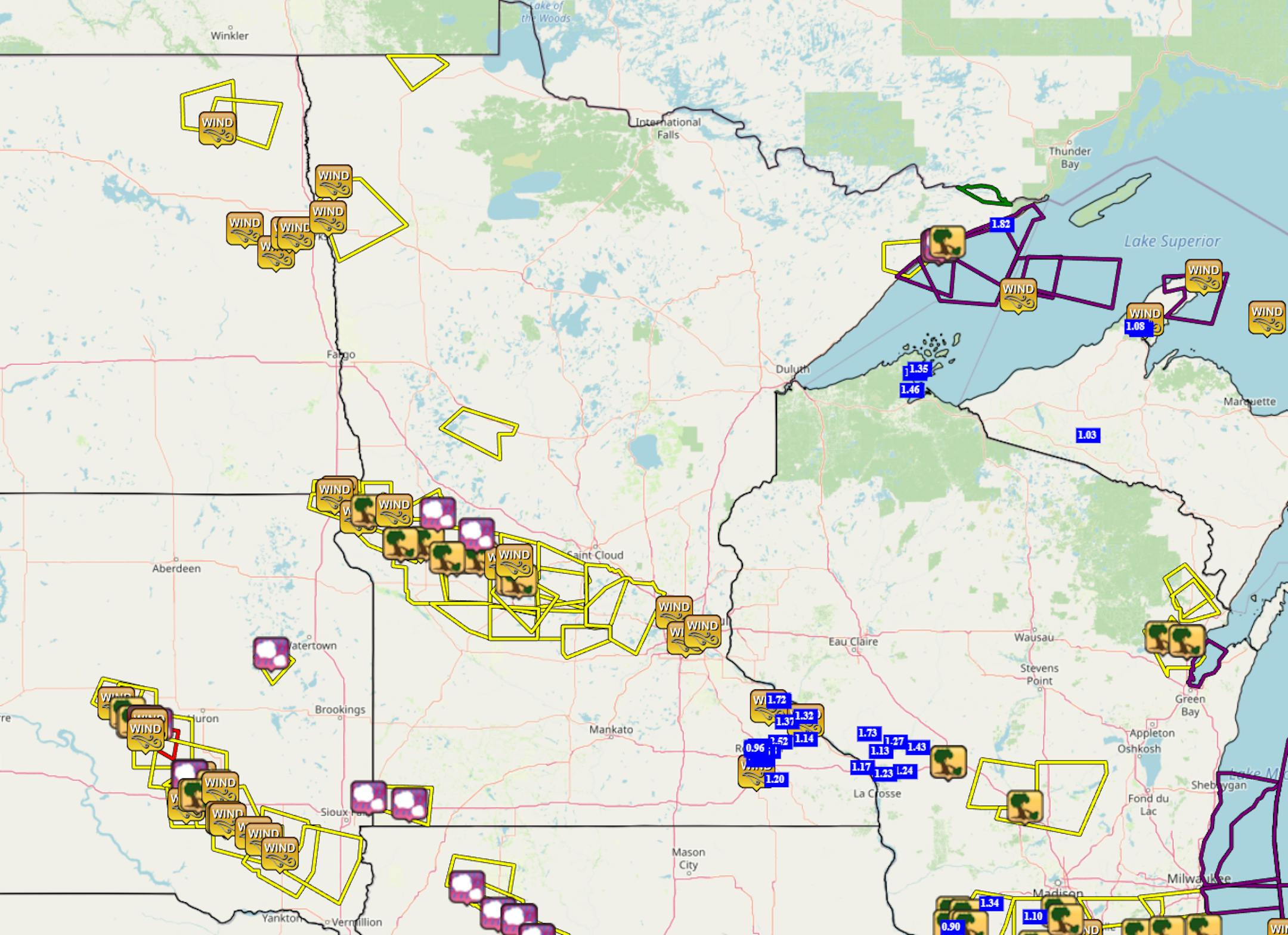
Storm reports from 6 AM Tuesday to 3:30 PM Wednesday.

As we went through Tuesday Night, a line of storms formed and moved southeast from the Minnesota/North Dakota/South Dakota border to the metro, causing wind damage. The top wind speed in the state from Tuesday Night was 75 mph in both Belgrade and Mallory (near East Grand Forks). A wind damage storm report from New London reported: "3-4 foot diameter trees and power poles have been snapped. Pontoons have been flipped. Some roof damage to buildings."

(The Minnesota Star Tribune)

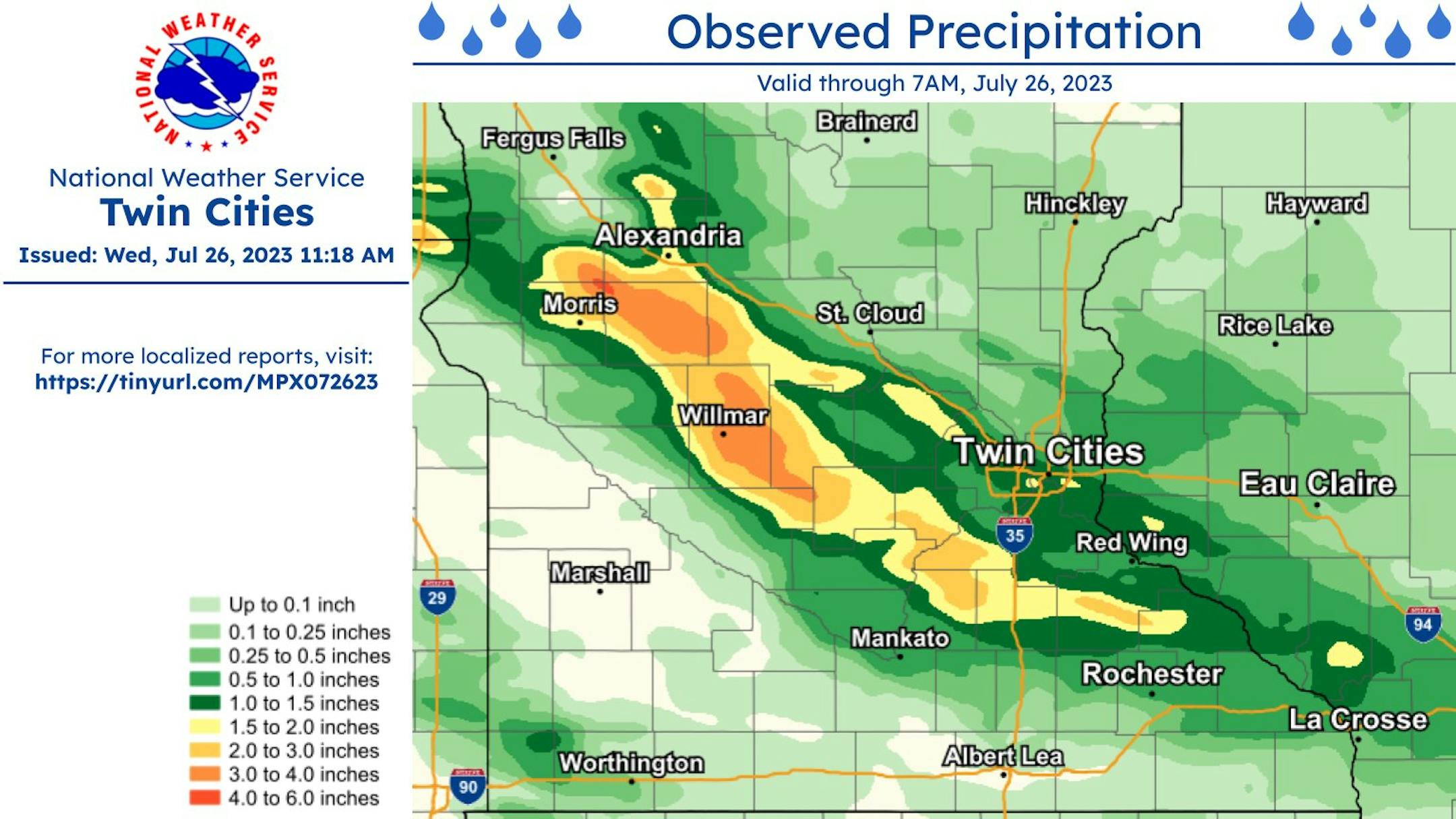
Heavy rain also fell with these storms, with some areas out toward Starbuck to Willmar to Hutchinson and New Prague picking up 2-3"+ of rain.

_______________________________________________

Heat Continues Thursday With Some Late Day Strong Storms

(The Minnesota Star Tribune)

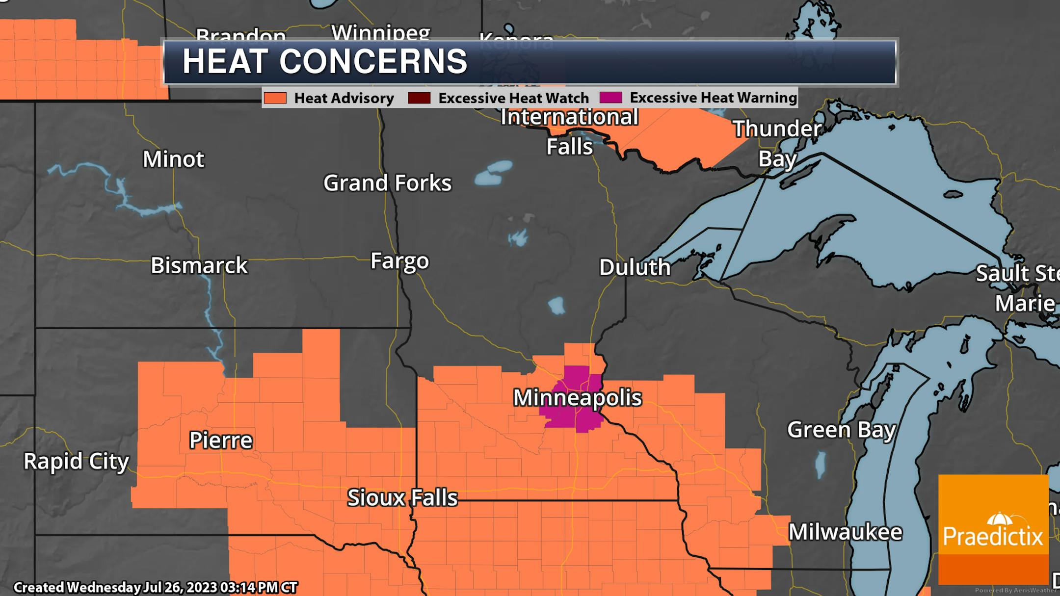
Excessive Heat Warnings are now in place across the metro from Noon to 8 PM Thursday as heat index values up to 105F will be possible. Across the Heat Advisory area in southern Minnesota, heat index values up to 100F will be possible Thursday afternoon.

(The Minnesota Star Tribune)

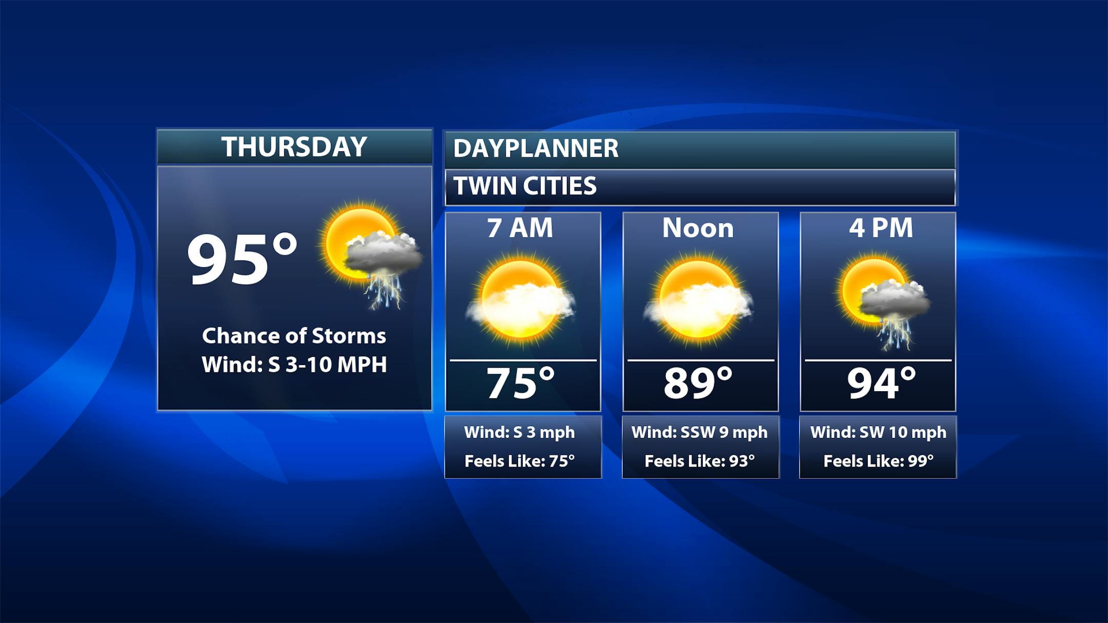
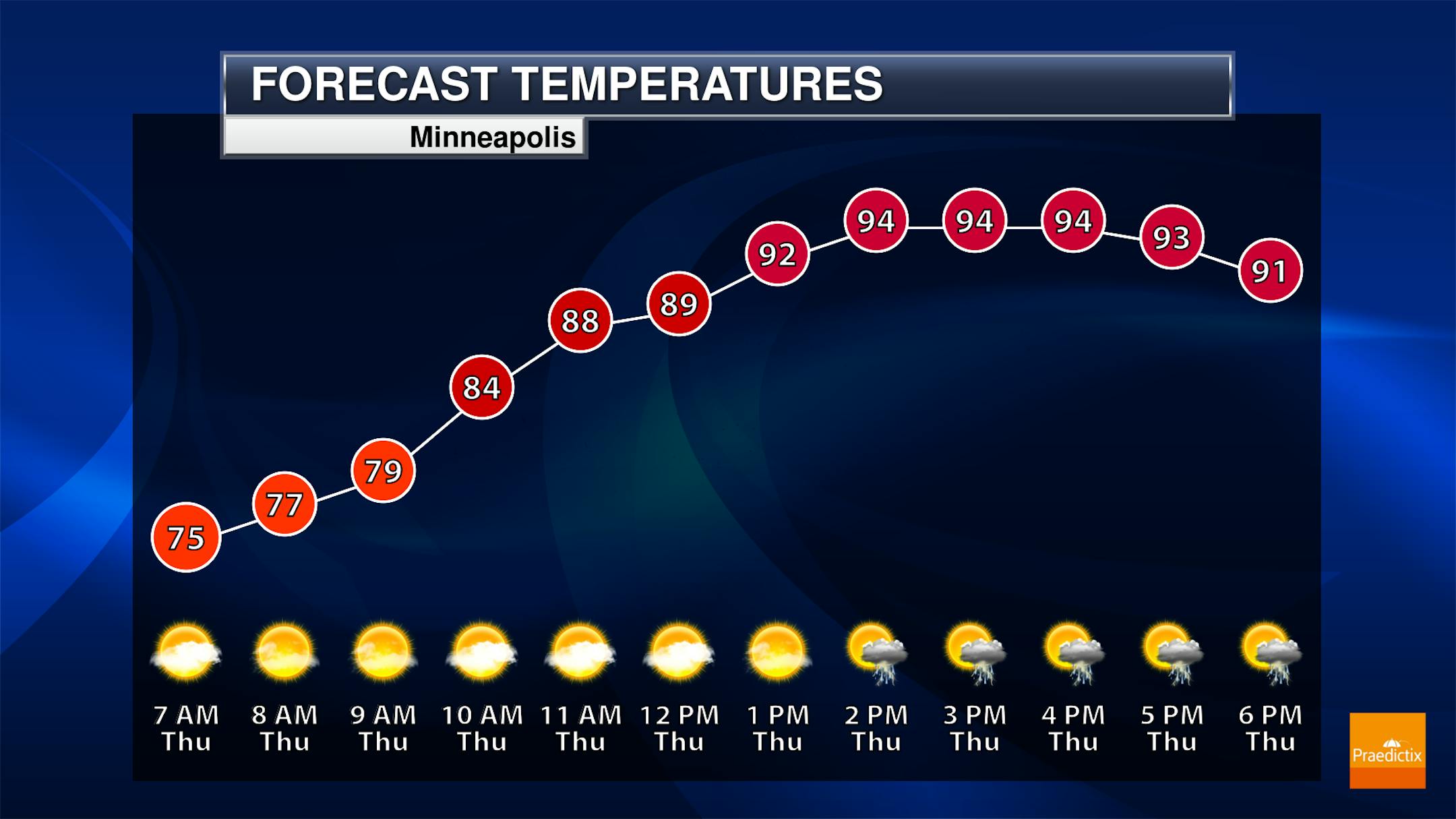
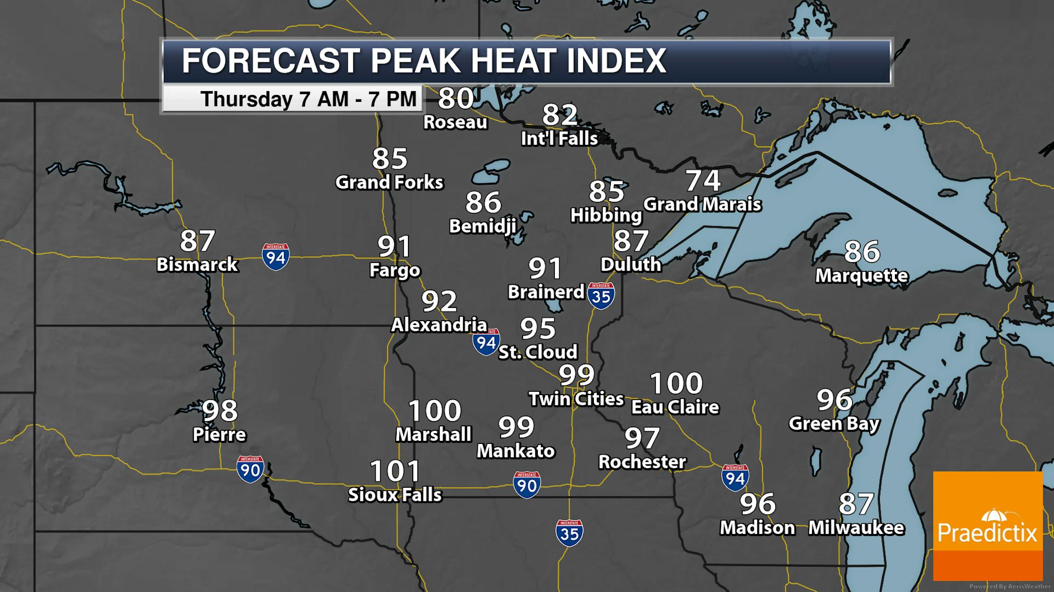
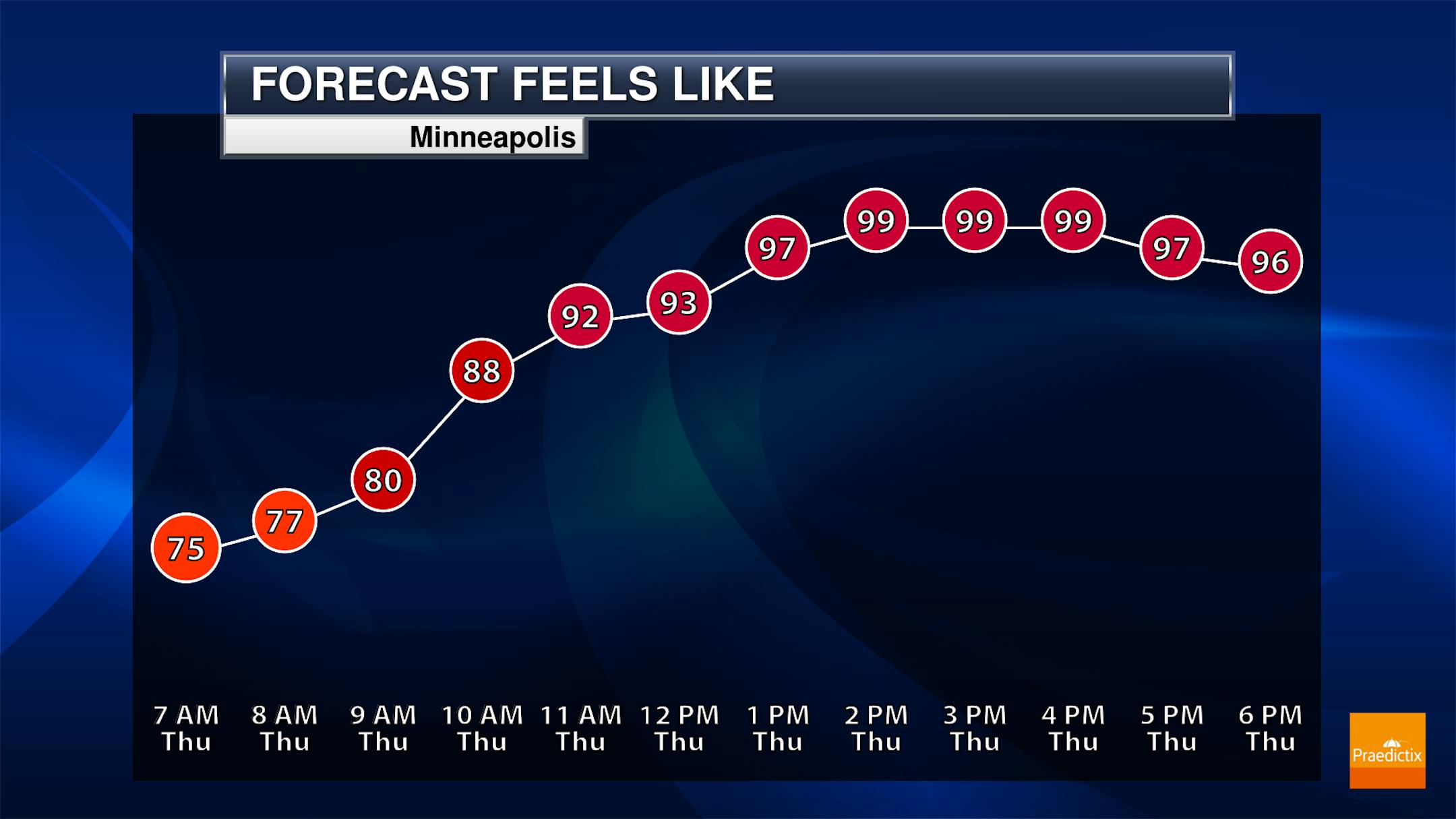
Another toasty day of weather is expected Thursday in the metro. Highs are expected to climb into the mid to upper 90s, dependent on potential cloud cover and storm activity. While I can't rule out a few showers or storms around during the morning commute, a better chance of some storms may pop up late in the afternoon and evening hours.

(The Minnesota Star Tribune)

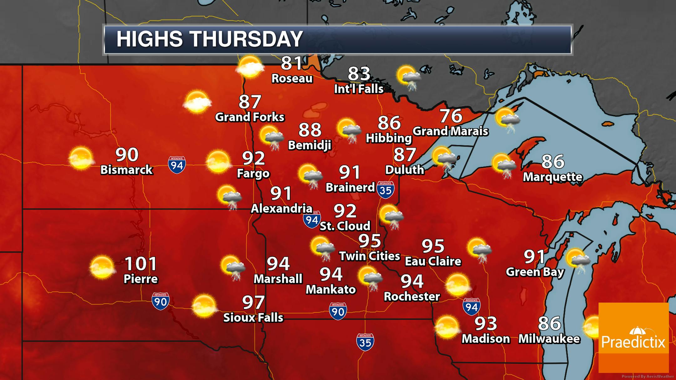
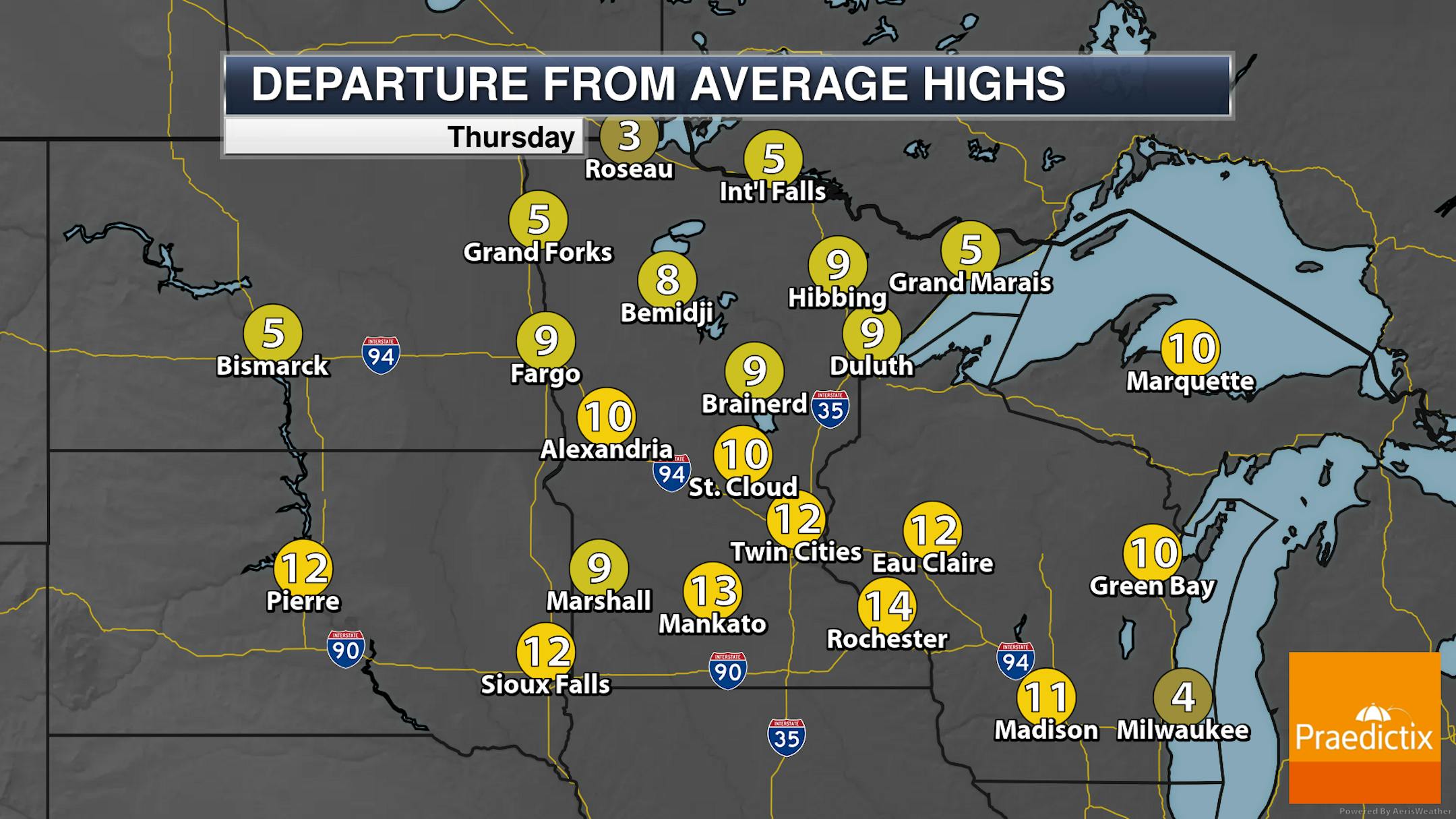
While a few roaming showers or storms will be about during the day, a better chance of storms will be likely late into the day and during the overnight hours. Otherwise, temperatures range from the 70s along the North Shore to around 100F in parts of southern Minnesota.

(The Minnesota Star Tribune)

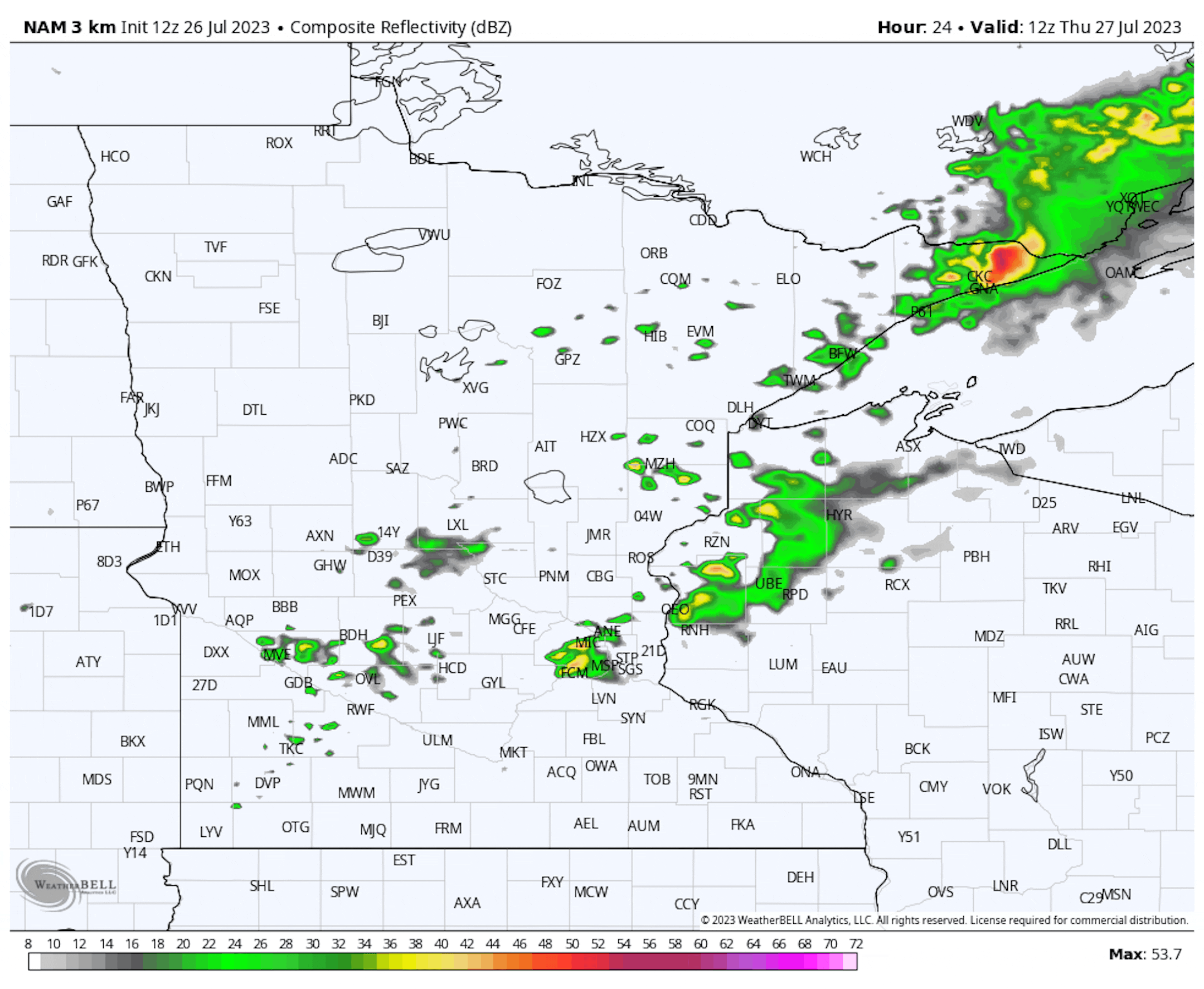
Forecast loop between 7 AM Thursday and 7 AM Friday.

Here's a look at the potential of storms as we head throughout the day. While a few showers or storms could be around during the morning and midday hours, a better chance of storms looks to pop across the state during the late afternoon into the overnight hours that could be severe.

(The Minnesota Star Tribune)

A few of those storms across the southern two-thirds of Minnesota Thursday could be strong to severe, with hail and wind the main threats.

_______________________________________________

Friday Strong Storms Before Calmer Weekend Weather

(The Minnesota Star Tribune)

Friday: More showers and storms will be possible during the day - some of which could be strong - as another frontal boundary slowly slips southward. Highs climb to the upper 80s.

Saturday: "Cooler" and calmer weather is expected Saturday, with mainly sunny skies and highs in the low 80s.

Sunday: Sunny conditions continue, but temperatures creep back up to the mid-80s.

(The Minnesota Star Tribune)

As mentioned above, additional showers and storms ahead of a second frontal boundary could be severe across the southern half of Minnesota Friday. Again, hail and wind are the primary threats.

_______________________________________________

Urban Heat Island Makes It Feel Even Hotter
By Paul Douglas

Urbanization magnifies heat. The Urban Heat Island can make it feel 5-10F hotter in the downtowns than it does in outlying suburbs or greater Minnesota. According to Climate Central 80% of the US population lives in cities prone to heat extremes amplified by asphalt and dark surfaces that absorb and retain heat, especially at night. Minneapolis and St. Paul are 7.8F hotter than surrounding rural communities.

Planting more trees, terraces and painting rooftops lighter (cooler) colors can help, but urban heating and climate change is a 1-2 punch.

Heat peaks today in the mid 90s. T-storms bubbling up later today should prevent us from getting as hot as we would be otherwise. Even so, expect a heat index near 100F in the metro before downpours arrive, with another spirited round of T-storms Friday ahead of a cooler front.

Canadian air flushes any lingering storms to our south this weekend with 80s and a welcome drop in humidity.

Have we seen the last of the 90s? Nope. With El Nino we may see 90s into September.

_______________________________________________

Paul's Extended Twin Cities Forecast

THURSDAY: Sweaty sun, PM T-storms. Wake up 75. High 95. Chance of precipitation 70%. Wind S 10-15 mph.

FRIDAY: Unsettled with more T-storms. Wake up 71. High 87. Chance of precipitation 70%. Wind NE 10-20 mph.

SATURDAY: Sunny with a drop in humidity. Wake up 64. High 84. Chance of precipitation 10%. Wind NW 7-12 mph.

SUNDAY: Plenty of sun, no complaints. Wake up 61. High 82. Chance of precipitation 10%. Wind NW 5-10 mph.

MONDAY: Warm sunshine, quite pleasant. Wake up 63. High 86. Chance of precipitation 10%. Wind S 5-10 mph.

TUESDAY: Partly sunny, stickier. Wake up 66. High 87. Chance of precipitation 20%. Wind SE 7-12 mph.

WEDNESDAY: Some sun, heating up again. Wake up 69. High 90. Chance of precipitation 20%. Wind S 7-12 mph.

_______________________________________________

Minneapolis Weather Almanac And Sun Data
July 27th

(The Minnesota Star Tribune)

*Length Of Day: 14 hours, 52 minutes, and 54 seconds
*Daylight LOST Since Yesterday: 2 minutes and 11 seconds

*When Do We Drop Below 14 Hours Of Sunlight? August 17th (13 hours, 59 minutes, 17 seconds)
*When Are Sunrises After 6 AM? August 2nd (6:00 AM)
*When Are Sunsets At/Before 8:30 PM? August 8th (8:30 PM)
_______________________________________________

This Day in Weather History
July 27th

1910: Giant hailstones fall in Todd and Wadena Counties. One stone weighed in at 5 pounds.

_______________________________________________

National Weather Forecast

(The Minnesota Star Tribune)

Hot weather continues across the Southwest and central United States on Thursday, with widespread 90s and 100s possible. We'll be watching storms across parts of the Rockies, the Upper Midwest and Northeast, and in Florida.

(The Minnesota Star Tribune)

Heavy pockets of rain are expected through the end of the week in the Great Lakes, Northeast, and the Florida Peninsula. In these areas, 2-4" of rain is possible.

_______________________________________________

Migration Into America's Most Flood-Prone Areas Has More Than Doubled Since the Start of the Pandemic

More from Redfin: "The most flood-prone U.S. counties saw 384,000 more people move in than out in 2021 and 2022—a 103% increase from the prior two years, when 189,000 more people moved in than out. The same trend took hold in the places most vulnerable to wildfires and heat as the pandemic homebuying boom and a housing affordability crisis pushed Americans into disaster-prone areas. The counties with the highest wildfire risk saw 446,000 more people move in than out over the past two years, a 51% increase from 2019 and 2020. And the counties with the highest heat risk saw 629,000 more people move in than out, a 17% uptick. This is according to a Redfin analysis of domestic migration data from the U.S. Census Bureau and climate-risk scores from First Street Foundation. We analyzed the counties in the contiguous U.S. that rank in the top 10% for flood and fire risk and the top 33% for heat risk, as measured by the share of residential properties at high risk."

Heat Waves and Cold Snaps Linked to More Fatal Heart Attacks, Study Finds

More from Gizmodo: "The global rise in extreme weather is likely to bring along more fatal heart attacks, new research this week suggests. The study found that exposure to heat waves and cold snaps was associated with higher odds of heart attack deaths. This associated risk was even greater on extreme heat days that also featured high levels of certain air pollutants. The research was led by scientists at the Sun Yat-sen University in Guangzhou, China. The team analyzed recent data collected on recorded heart attack deaths from the Jiangsu province of the country, between 2015 to 2020. Then they cross-referenced that information with environmental data in the area, focusing on especially hot and cold days as well as levels of fine particulate matter (particles of air pollution that are smaller than 2.5 microns)."

Warming Could Push the Atlantic Past a 'Tipping Point' This Century

More from the New York Times: "The last time there was a major slowdown in the mighty network of ocean currents that shapes the climate around the North Atlantic, it seems to have plunged Europe into a deep cold for over a millennium. That was roughly 12,800 years ago, when not many people were around to experience it. But in recent decades, human-driven warming could be causing the currents to slow once more, and scientists have been working to determine whether and when they might undergo another great weakening, which would have ripple effects for weather patterns across a swath of the globe. A pair of researchers in Denmark this week put forth a bold answer: A sharp weakening of the currents, or even a shutdown, could be upon us by century's end. It was a surprise even to the researchers that their analysis showed a potential collapse coming so soon, one of them, Susanne Ditlevsen, a professor of statistics at the University of Copenhagen, said in an interview. Climate scientists generally agree that the Atlantic circulation will decline this century, but there's no consensus on whether it will stall out before 2100."

_______________________________________________

Follow me on:

Thanks for checking in and have a great day!

- D.J. Kayser

(The Minnesota Star Tribune)

about the writer

D.J. Kayser

See More