

Windy With Rain, Snow & Chilly Temps
Here's the weather outlook from AM Wednesday to PM Sunday. The same storm system responsible for steady rains across the region on Tuesday will continue to swirl around the Midwest Wednesday and Thursday with more wind, rain, snow and chilly early April temps. We'll finally see some improvement late Friday & Saturday, but could see a few more light rain showers PM Sunday as a weak disturbance slides through the region.

Precipitation Outlook
According to NOAA's WPC, the precipitation outlook through Friday shows decent liquid tallies across the region. Total amounts could range from 0.50" to nearly 1.0" across the region with some of the heaviest across the northern part of the state, where heavier snow will be possible.

Snowfall Potential Through PM Wednesday
Here's the snowfall potential through 7pm Wednesday. Note the heaviest will be possible in northern part of the state and especially the Arrowhead, where winter weather headlines have been posted. A few spots along the North Shore of MN could see near 10" to 15" of snow through AM Friday.

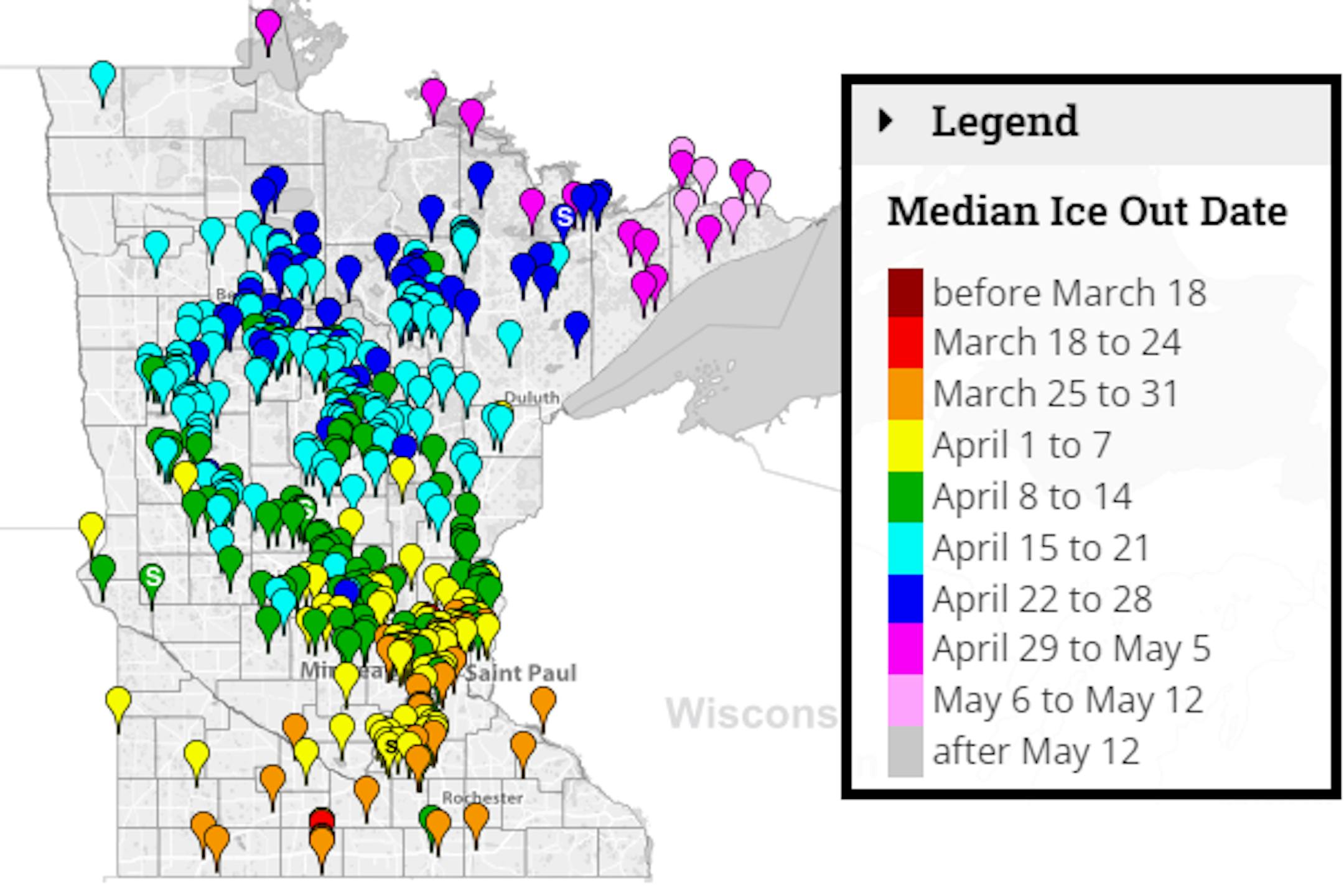
2022 Official Ice Out Dates
Hey - Look at that! Thanks for recent milder weather and areas of rain, a few lakes in the southern part of the state have officially gone ice out! Look for more ice outs over the coming days and weeks. It won't be long now before the land of 10,000 unfrozen lakes returns!

Average Ice Out Dates
We're still several weeks away from ice out across parts of the state, but according to the MN DNR, here's a look at the average ice out dates for lakes across the state. Note that some lakes across the southern part of the state typically see ice out around the end of March. Lake Minnetonka typically doesn't see ice out until mid April. A few lakes in far northern & northeastern MN don't see ice out until late April or early May.
Status of Spring
"April 4, 2022 - Spring leaf out continues to progress across the country. Our spring leaf anomaly compares the arrival of spring leaf out this year to a long-term average of 1991-2020. After a slow start to spring across much of the Southeast, spring is progressing more rapidly, arriving days to weeks early across the southern part of the Midwest, the Southern Appalachians, the mid-Atlantic, and the Northeast. Albany, NY is a week early. In western states, spring leaf out is patchy, arriving a week late in some locations and over a month early in others. Parts of Montana and South Dakota are 2-3 weeks early. Spring bloom has also started to arrive in southern states, days to a week late in Texas and Florida and days to several weeks early in California. Spring bloom is over a week early in parts of Georgia, the Carolinas, and Virginia."


