First 60F Of 2023 Occurred Saturday

Warmth and sunshine dominated Saturday across the region. MSP Airport hit 60F for the first time, climbing to a high of 67F. It was 14F degrees above average and marked only the ninth day since the beginning of March to have an above-average high.

_______________________________________________

Another 60F High Monday With Sunny Skies

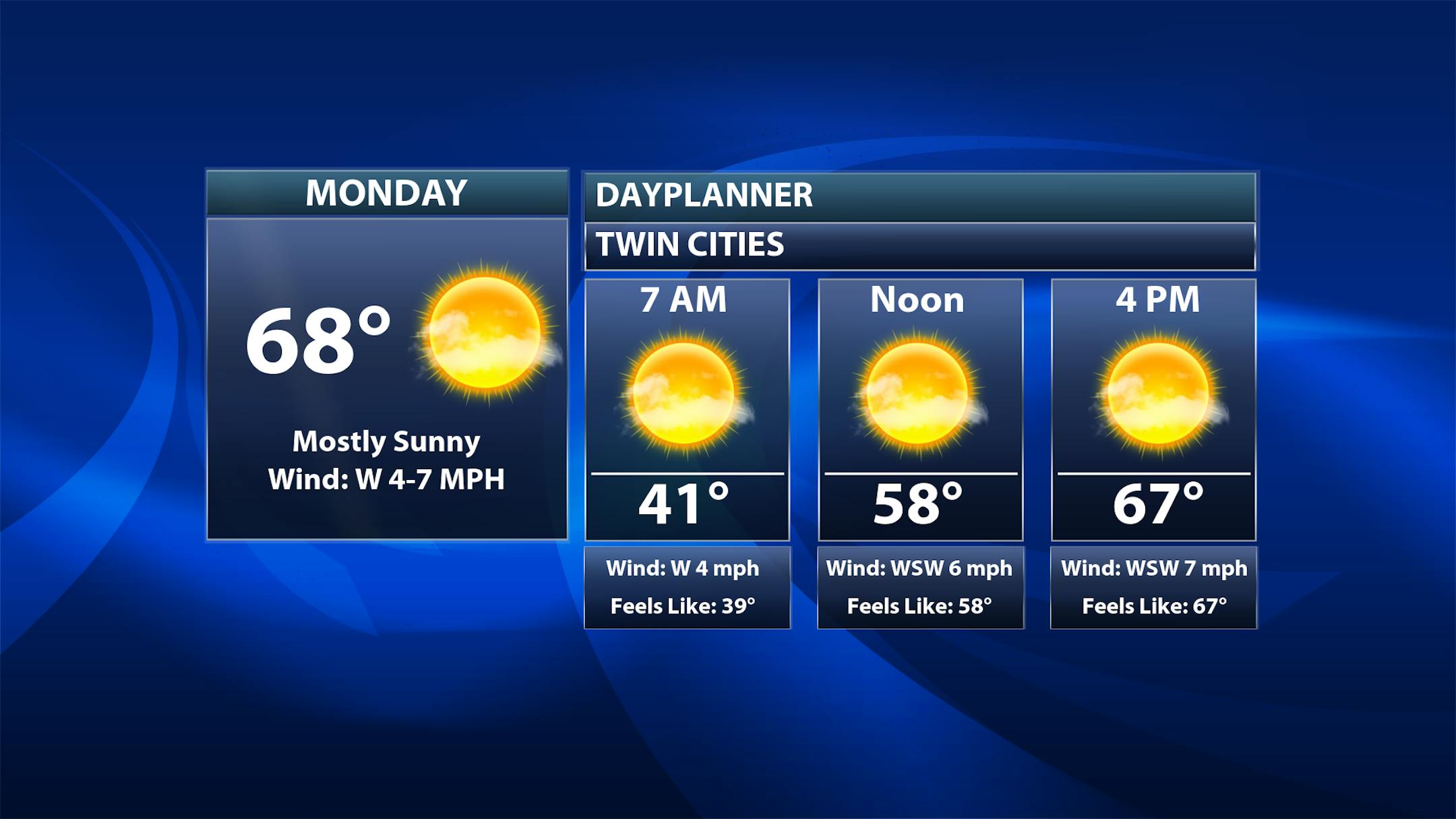
After a cooler Sunday due to cloud cover and some scattered showers across the region, we'll see temperatures warm back up under sunny skies on Monday. In fact, we could approach 70F here in the metro during the afternoon after starting off around 40F. Whether Monday or Tuesday sees the first 70F of the year - it is expected this week (more on that below).

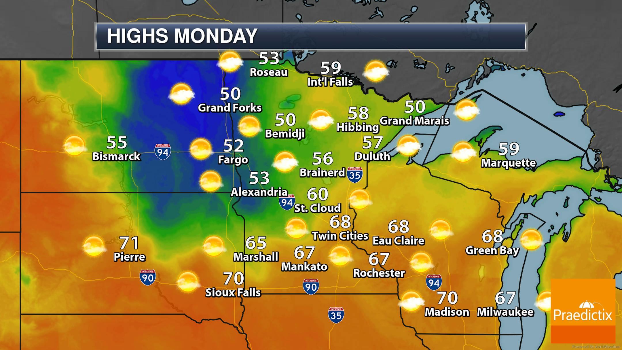
You can see a defined area on the statewide map for Monday across central and northern Minnesota where temperatures are cooler than they will be in southern Minnesota - this is due to the snow pack on the ground keeping temperatures down. 60s are likely across southern Minnesota, with mainly 40s and 50s where a lot more snow is on the ground.

_______________________________________________

First 70F - Even 80F? - On The Way This Week

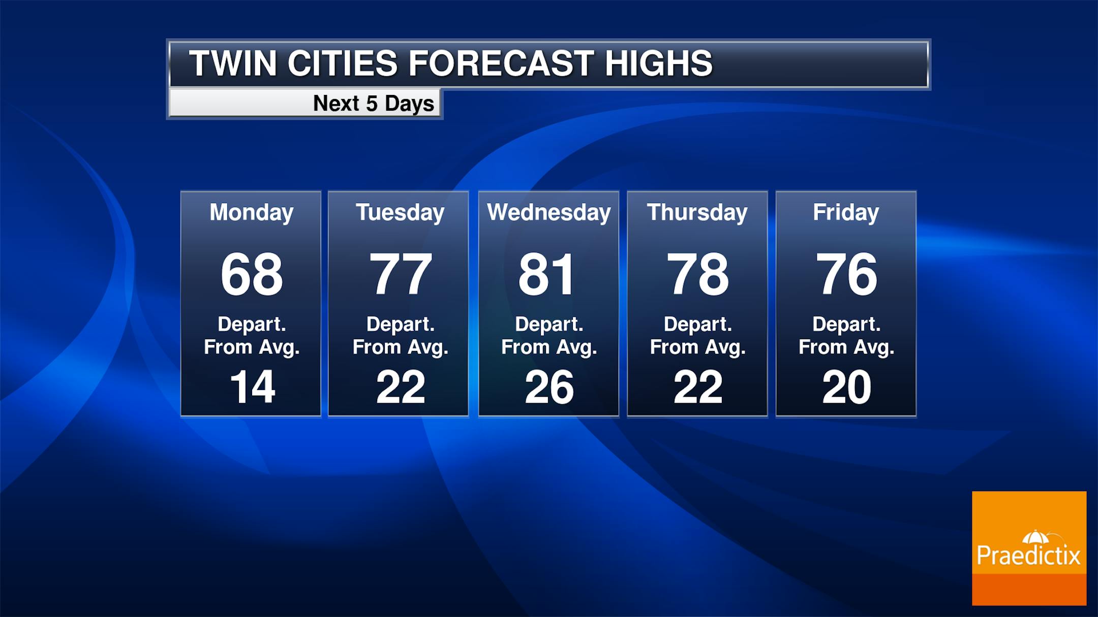
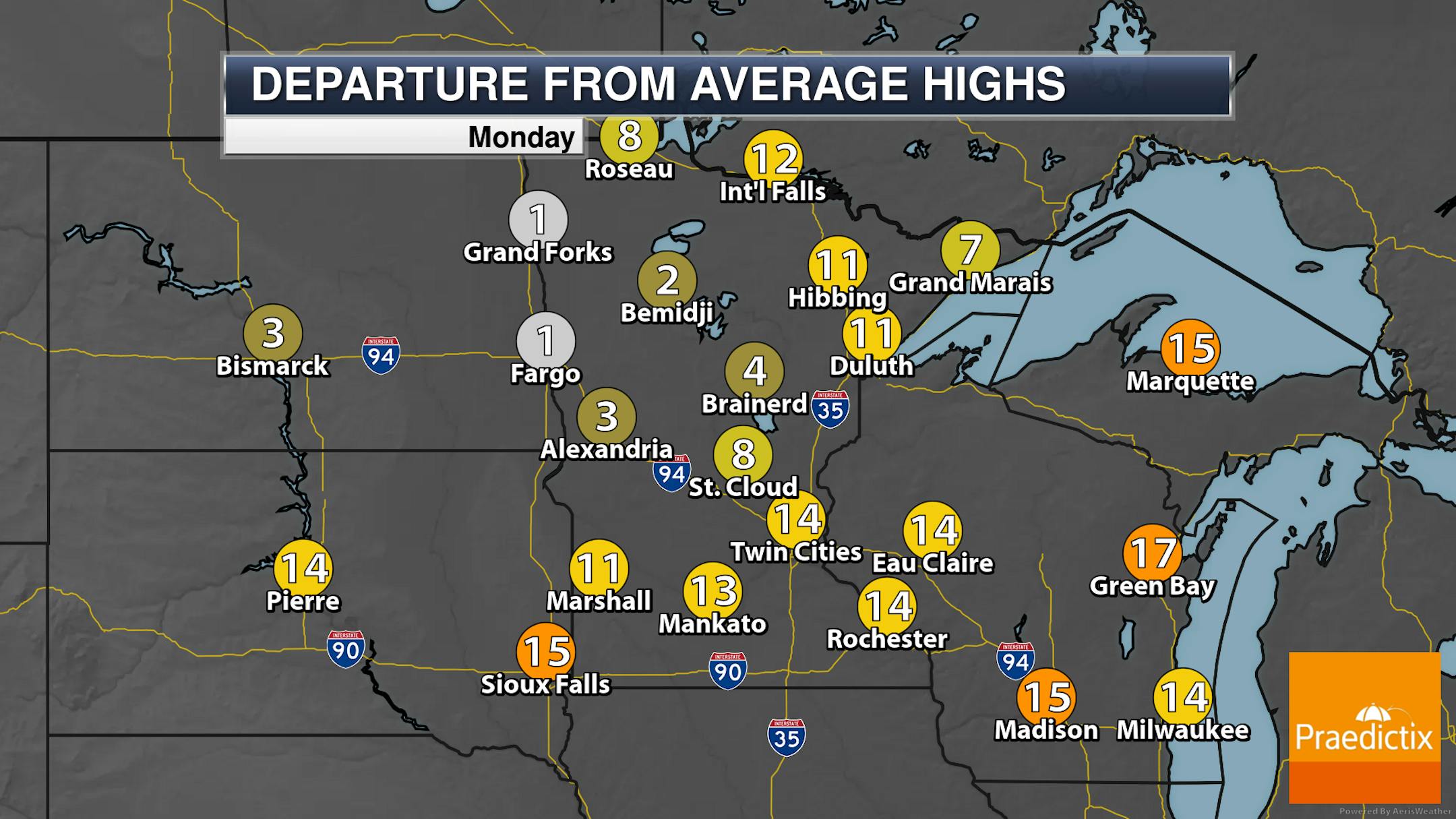
Well, how's it like going from winter right to summer? It seems like that happens more often where it feels like we're skipping that Spring step… and temperatures this week make this year seem like one of those years as well. After Monday's 60s, we'll see the first 70F of the year on Tuesday… then potentially another step up to the first 80F of 2023 on Wednesday. The record for Wednesday, by the way, is 83F in 1931. These highs midweek will be a good 20-25F degrees above average! Temperatures moderate back into the 70s for the end of the week.

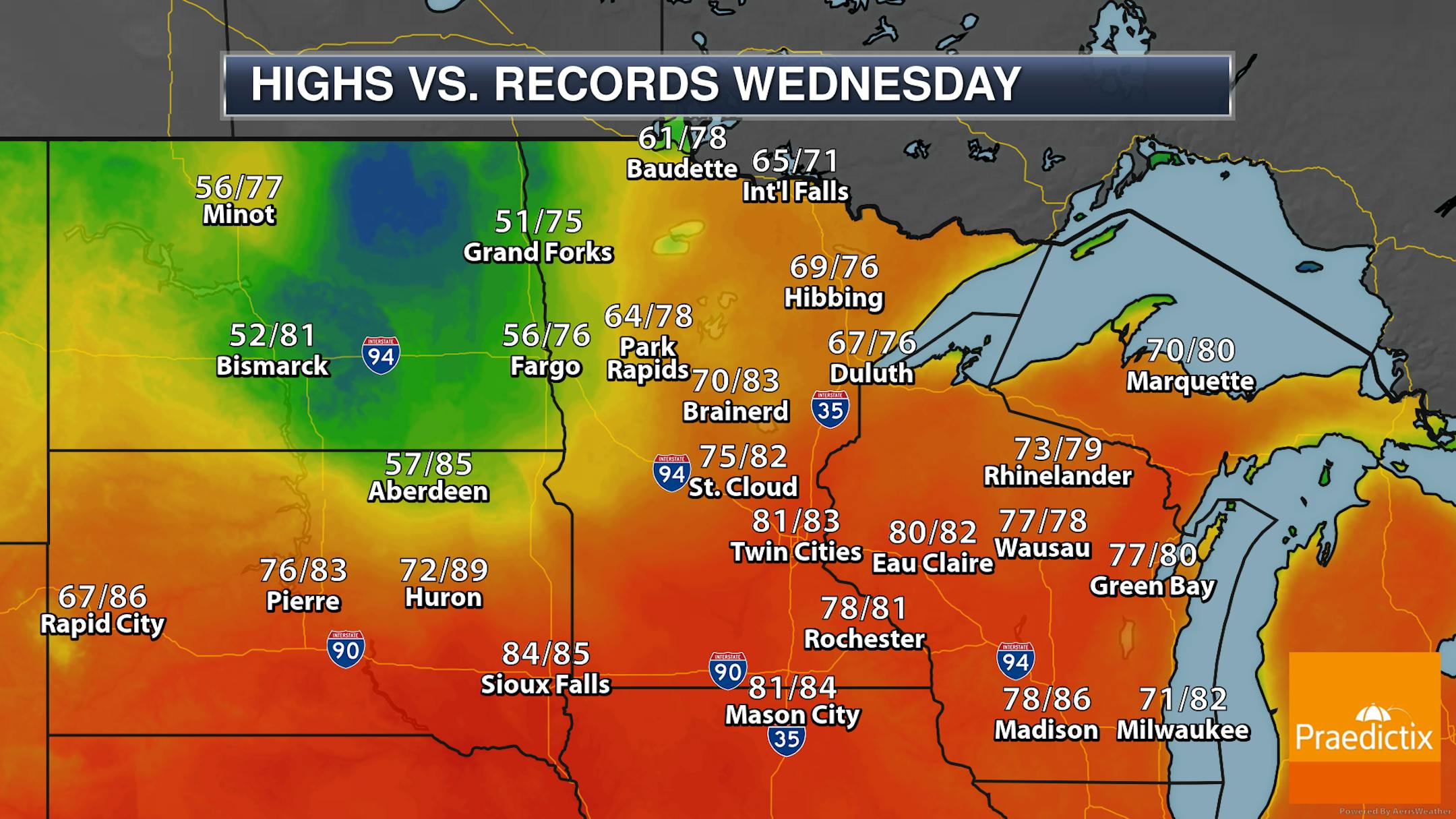
Looking closer at Wednesday, several other locations could see highs approaching records in the region, including Rochester, Eau Claire, Sioux Falls, Mason City, Green Bay, and Wausau. Even International Falls could be within 6F degrees of their record!

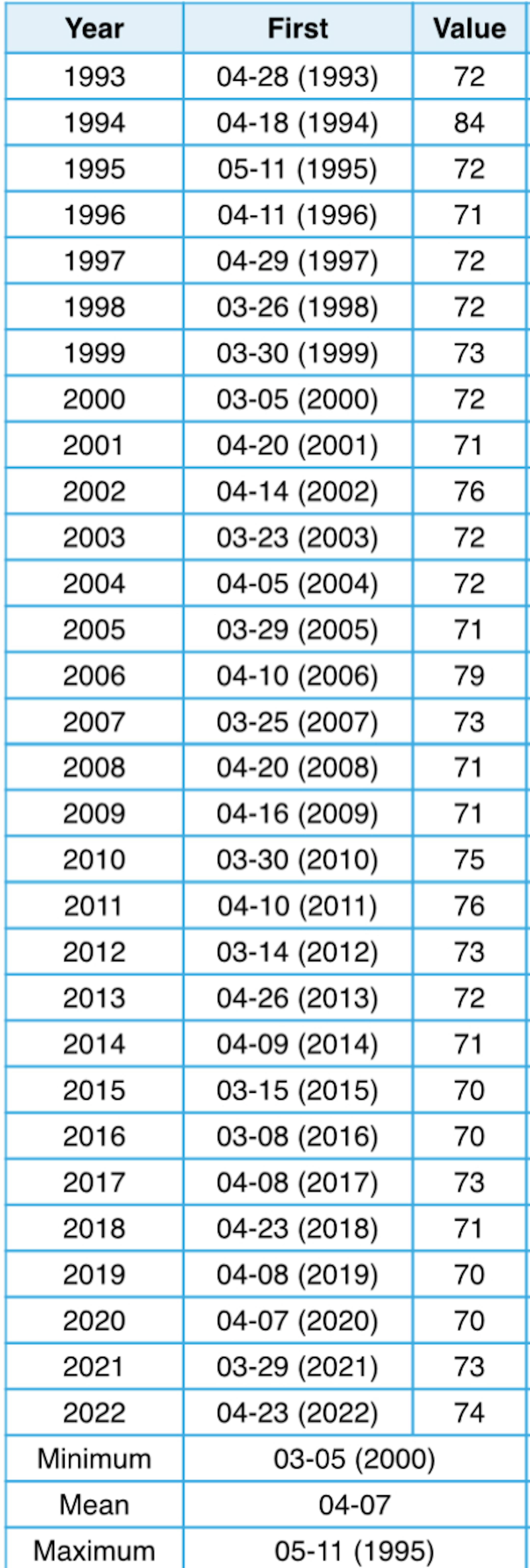
Over the past 30 years (1993-2022), our average first 70F degree day has occurred on April 7th - so whenever we hit 70F later this week, it will be slightly behind average. Last year the first 70F occurred on April 23rd.

Meanwhile, over the past 30 years, the first 80F degree day hasn't occurred on average until April 29th, so that'll be a value we're actually ahead of schedule on! Last year the first 80F was May 9th.

_______________________________________________

Rain Potential Late Week With Cooler Temps

Six-hour precipitation loop between 7 AM Friday and 7 AM Sunday.

After we see a mostly dry week, we will start to see rain chances move in as we head into Friday and the weekend. Most models advertise under an inch of rain at the moment, but we'll keep an eye on it. And yes, some models show the potential of a little bit of snow on the back edge Saturday Night as temperatures dip just enough to change some of it over. As we get closer, we'll be able to better define when the precipitation looks to move through - and if we have that change to a little snow.

With the rain chances heading into the weekend will come cooler temperatures. Right now, highs are only expected to make it to the 50s and 60s next weekend, which will continue into at least the first part of the third full week of April. Without a doubt, 70s and 80s will (of course) return, but you may want to sneak out and enjoy some of it this week! Especially before all the mosquitoes start buzzing around.

_______________________________________________

Watching For Flooding

With the quick warm-up across the region, we will be in the middle of river flood season over the next few weeks. River flooding can be expected here across central and southern Minnesota over the next week and a half - these are the expected peak river levels in the next nine days.

The North Central River Forecast Center is expecting the Crow River at Rockford to reach major flood stage by early next weekend. At 10 feet, "Low lying areas and some roads along the river begin to experience flooding" and at 15 feet, "Sanitary sewers serving homes closest to river may begin to back up."

_______________________________________________

June This Week - March Returns Saturday

By Paul Douglas

Explored any interesting potholes lately? Less commuting, more spelunking. If I find gold can I keep it? Don't blame MnDOT or some beleagured bureaucrat. The weather is entirely to blame.

By my rough calculation MSP has experienced 54 days with a freeze/thaw cycle since January 1. In other words: temperatures rising above AND below 32F in the same 24-hour cycle. On 54 separate days in 2023. Sadly, water expands when it freezes. During the day melting allows water to trickle into pavement cracks, water that turns to ice and expands at night, slowly pulverizing the highway surface over time.

But I digress. A taste of early June is imminent with sunshine and 70s Tuesday through Friday. 80F is possible Wednesday.

If you have fortitude and a strong stomach read on. Thunder late Friday heralds the arrival of a colder front. A storm spinning up along that chilly slap may dump snow on our heads Saturday night. ECMWF predicts plowable amounts nearby. For the love of everything good and holy, I pray it's wrong.

_______________________________________________

Paul's Extended Twin Cities Forecast

MONDAY: Sunny and spectacular. Wake up 40. High 69. Chance of precipitation 0%. Wind SW 7-12 mph.

TUESDAY: Lukewarm sunshine. Wake up 48. High 76. Chance of precipitation 0%. Wind SW 10-20 mph.

WEDNESDAY: Sunny, typical for late June. Wake up 56. High 80. Chance of precipitation 0%. Wind SW 10-20 mph.

THURSDAY: Partly sunny, still balmy. Wake up 47. High 77. Chance of precipitation 10%. Wind S 10-20 mph.

FRIDAY: Fading sun, few T-showers late? Wake up 56. High 74. Chance of precipitation 70%. Wind S 10-20 mph.

SATURDAY: Rain may change to snow at night. Wake up 38. High 40. Chance of precipitation 80%. Wind N 10-20 mph.

SUNDAY: Slushy start? Slow clearing. Wake up 32. High 44. Chance of precipitation 50%. Wind NW 15-25 mph.

_______________________________________________

Minneapolis Weather Almanac And Sun Data
April 10th

*Length Of Day: 13 hours, 14 minutes, and 25 seconds
*Daylight GAINED Since Yesterday: 3 minutes and 3 seconds

*When do we see 14 Hours of Daylight?: April 26th (14 hours, 1 minute, 49 seconds)
*When Is The Sunrise At/Before 6:30 AM? April 14th (6:30 AM)
*When Is The Sunset At/After 8 PM? April 17th (8:00 PM)

_______________________________________________

This Day in Weather History
April 10th

1977: A record high of 86 is set at Redwood Falls.

_______________________________________________

National Weather Forecast

A lot of the nation will be quiet for Easter Monday. Showers and mountain snow are expected with a system in the Pacific Northwest. With a frontal boundary nearby, showers and storms will fall across Florida. Scattered storms will also be possible across the Plains with a trough of low pressure. Some record highs will be possible in the western United States - particularly in the Southwest near the Mexican border.

The most impactful weather through the beginning of the week will be in the Pacific Northwest, where areas near the coast will see at least 3" of rain and the Cascades will see multiple feet of snow.

_______________________________________________

The Great American Solar Eclipse of 2024 is 1 year away! Where is the best place to see it?

More from Space.com: "Mark Monday, April 8, 2024, on your calendar as "Solar Eclipse Day," for if the weather is fair, you should have no difficulty observing a partial eclipse of the sun from much of North America. This event is associated with a total eclipse, in which the moon completely blocks out the disk of the sun. During a total eclipse, we are treated to a rare view of the sun's pearly corona; a "bucket-list event." At the same time, darkness settles over the landscape allowing for some of the brighter stars and planets to be seen. Meanwhile, an eerie saffron glow skims the horizon. In the United States, the path of totality, averaging 123 miles (198 km), runs from southwest Texas to northern New England. Cities within the totality zone include San Antonio, Austin, Dallas-Fort Worth, Little Rock, Cape Girardeau, Indianapolis, Cleveland, Erie, Buffalo, Rochester, Syracuse, Burlington and Presque Isle. The duration of totality will vary from nearly four and a half minutes in Texas to over three and a quarter minutes in Maine. An estimated 32 million people live inside of the totality path and countless millions more are anticipated to travel into the path in the days leading up to "E-Day.""

Why MLB players could be hitting hundreds of more home runs each season by the end of the century

More from CNN: "Whether it's a change in the baseballs themselves, better analytics or more robust player training, many have speculated about what could be behind the upward trend in Major League Baseball home runs in recent years. But new research released Friday raised another potential factor: climate change. The study, published in the Bulletin of the American Meteorological Society, found that more than 500 home runs since 2010 can be linked to unusually warm temperatures. If temperatures continue to warm rapidly because of planet-cooking pollution, climate change could end up accounting for 10% of all home runs by the end of the century."

A dramatic new EPA rule will force up to 60% of new US car sales to be EVs in just 7 years

More from Electrek: "The Environmental Protection Agency (EPA) is expected to make a groundbreaking announcement this week that will make the majority of new US car sales EVs by 2032, according to a breaking New York Times scoop. The EPA's administrator, Michael S. Regan, is expected to announce proposed limits on tailpipe emissions on Wednesday in Detroit. The Times noted that its sources "spoke on condition of anonymity because the information had not been made public." It will be the federal government's most aggressive climate legislation yet, and will make the US a world leader in the efforts to cut transportation emissions."

_______________________________________________

Follow me on:

Thanks for checking in and have a great day!

- D.J. Kayser