Friday: Air Quality Alert Continues; Stretch Of 90F Heat Saturday Into Mid-Next Week

August 18, 2023 at 12:00AM
(The Minnesota Star Tribune)

Air Quality Alert Continues

(The Minnesota Star Tribune)

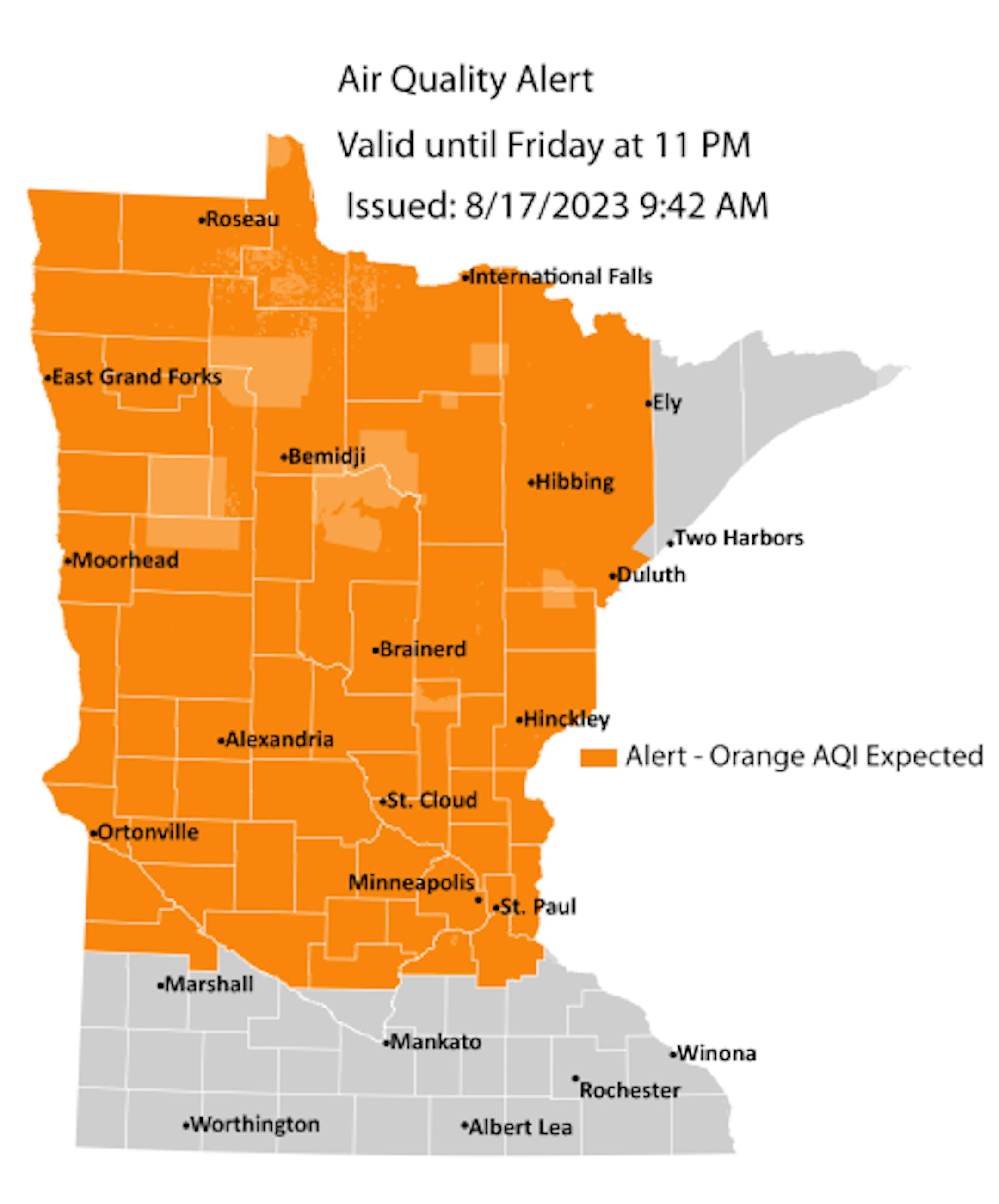
An Air Quality Alert continues through 11 PM Friday for a good chunk of Minnesota. The smoke concentration wasn't as heavy as originally expected, so portions of southern Minnesota and the Arrowhead were canceled from the alert. However, in areas still under the Air Quality Alert, the air quality index is expected to reach the Unhealthy for Sensitive Groups (orange) category - and already had in northwestern Minnesota as of Thursday afternoon. You can read more about the updated Air Quality Alert from the Minnesota Pollution Control Agency. An Air Quality Alert is also in place across all of Wisconsin through the weekend as we see poor air quality over there as well.

(The Minnesota Star Tribune)

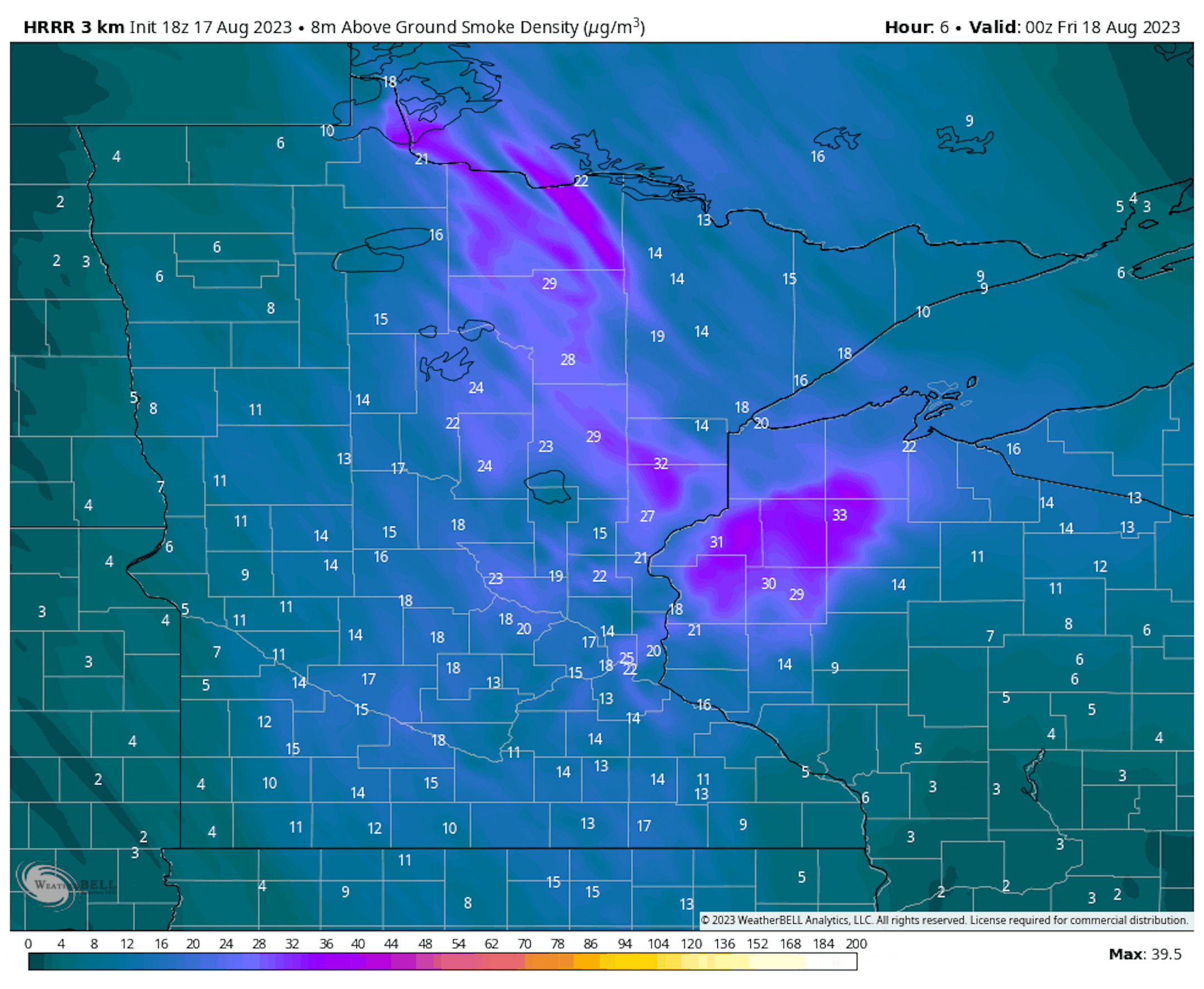
Forecast near-surface smoke from 7 PM Thursday to 7 AM Saturday.

Smoky skies will continue across Minnesota as we head throughout the day on Friday, but a strong southerly breeze will help to kick the smoke out as we head toward Friday Night.

_______________________________________________

Friday: Smoky, Starting To Warm Up

(The Minnesota Star Tribune)

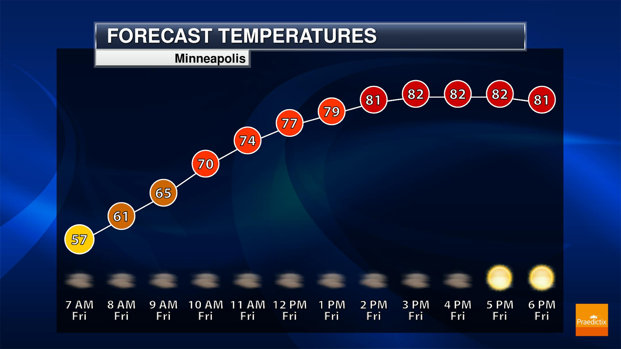
Smoky skies continue on Friday here in the metro, causing poor air quality and potentially lower visibility. Besides the haze/smoke, the skies will be mainly sunny. Morning temperatures start off in the mid-50s (too bad you can't have the windows open!) with highs in the low 80s.

(The Minnesota Star Tribune)

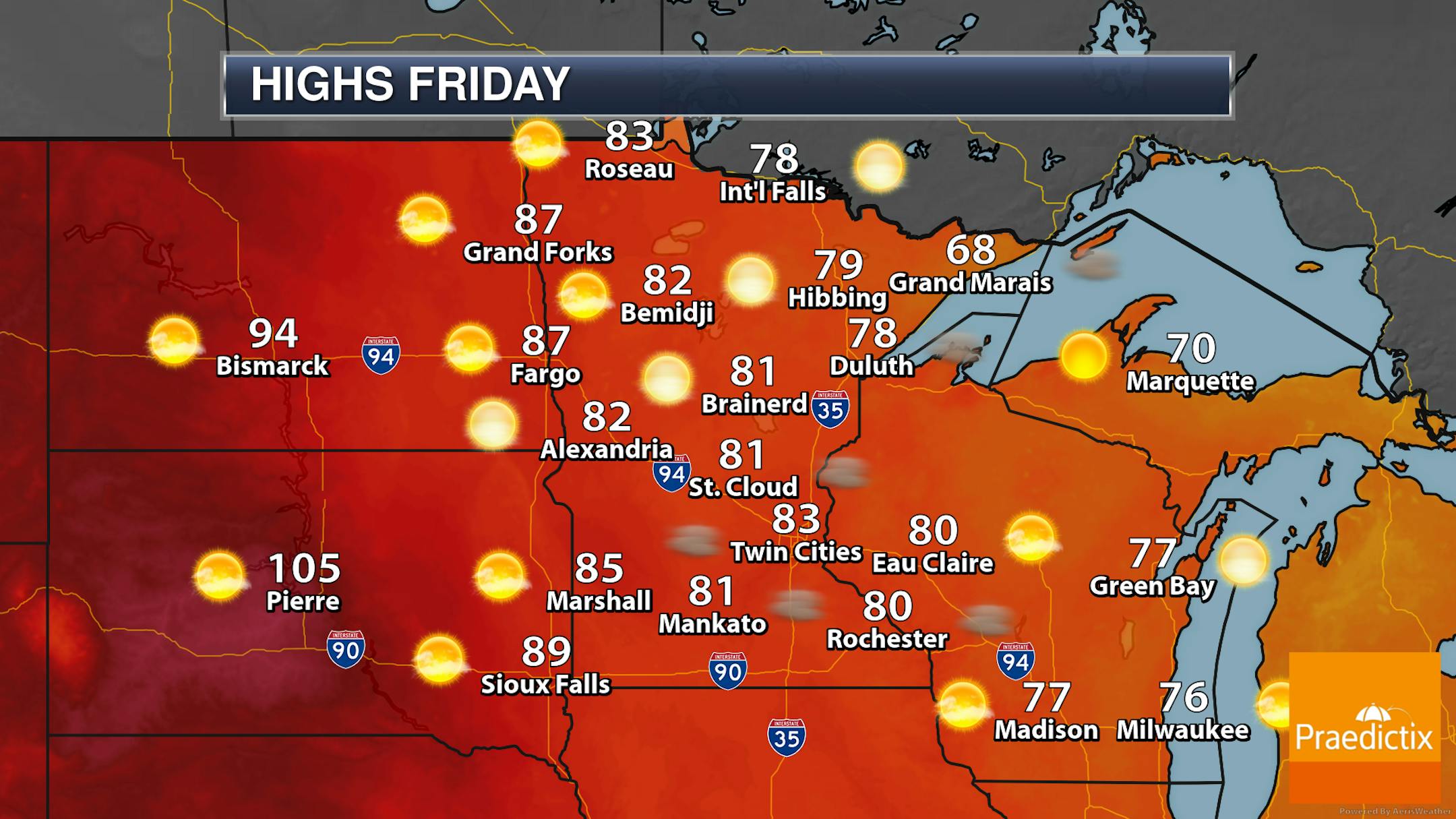
Smoky, hazy skies are expected across much of the state on Friday due to that Canadian wildfire smoke. Temperatures range from the 60s and 70s in the Arrowhead to the 80s across much of the rest of the state.

_______________________________________________

Heat Wave Starts Saturday - At Least Four Days Of 90F+ Heat

(The Minnesota Star Tribune)

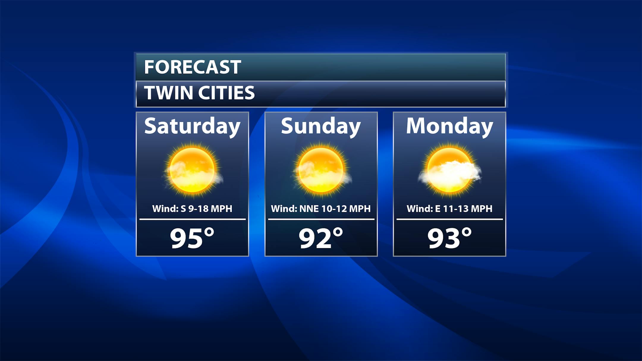
Saturday: Any ground-layer smoke should be gone as we head into Saturday, but our attention now turns toward a brewing heat wave. Sunny skies and a strong southerly breeze will boost temperatures into the mid-90s, with heat index values in the upper 90s. The record high Saturday for MSP is 97F in 1976.

Sunday: Hot, sunny weather continues with highs in the low 90s and heat index values in the mid-90s. The record high Sunday for MSP is 97F in 1972.

Monday: Much of the same - mainly sunny with continuing heat. Highs will be in the low 90s with heat index values in the mid-90s. The record high Monday for MSP is 98F in 1947.

(The Minnesota Star Tribune)

We also have a shot at 90F degree highs as we head toward Tuesday and Wednesday, though it doesn't look as warm in the metro as what we'll see Saturday-Monday. Tuesday's record high at MSP is 97F in 1971, and Wednesday's is 97F in 1948.

_______________________________________________

Significant Heat Wave Next Week
By Paul Douglas

I did not have Hurricane Hilary tracking toward Los Angeles on my 2023 Weather Bingo Card. For the record, Hilary will weaken as it passes over cooler water, but it may impact San Diego and Los Angeles as a tropical storm, with 5-10" rains inland. Crazy.

The capital of Canada's Northwest Territories, Yellowknife, a city of 20,000, is being evacuated due to wildfires. This summer has brought a new level of heat and fire to much of the Northern Hemisphere.

A few days ago the heat index at Qeshm Dayrestan Airport in Iran hit 178F (new world record for the highest dew point of 97F). Good grief.

A heatwave more typical of mid-July than late August is setting up from Saturday into most of next week. I see mid-90s Saturday, again next Tuesday, Wednesday and maybe Thursday - Day 1 of the MN State Fair. But of course. Maybe a lonely T-storm Monday, but the pattern isn't ripe for rain anytime soon.

The average high now at MSP is 81F. Will someone fax or page me at my favorite cubicle when our weather becomes "normal"?

_______________________________________________

Paul's Extended Twin Cities Forecast

FRIDAY: Warm sunshine. Wake up 56. High 83. Chance of precipitation 0%. Wind S 10-20 mph.

SATURDAY: Sizzling sunshine, stiff breeze. Wake up 71. High 94. Chance of precipitation 0%. Wind S 15-25 mph.

SUNDAY: Partly sunny, not as sweaty. Wake up 71. High 89. Chance of precipitation 10%. Wind NE 10-20 mph.

MONDAY: Muggy with a stray T-storm. Wake up 70. High 92. Chance of precipitation 30%. Wind S 10-20 mph.

TUESDAY: Sweltering sun, feels like 105-110? Wake up 76. High 98. Chance of precipitation 10%. Wind S 8-13 mph.

WEDNESDAY: Heatwave continues. Tropical. Wake up 77. High 94. Chance of precipitation 10%. Wind S 8-13 mph.

THURSDAY: More clouds, slight relief. Wake up 75. High 88. Chance of precipitation 20%. Wind SW 10-20 mph.

_______________________________________________

Minneapolis Weather Almanac And Sun Data
August 18th

(The Minnesota Star Tribune)

*Length Of Day: 13 hours, 56 minutes, and 28 seconds
*Daylight LOST Since Yesterday: 2 minutes and 49 seconds

*When Do We Drop Below 13 Hours Of Sunlight? September 7th (12 hours, 57 minutes, 11 seconds)
*When Are Sunrises After 6:30 AM? August 28th (6:30 AM)
*When Are Sunsets At/Before 8:00 PM? August 27th (7:59 PM)
_______________________________________________

This Day in Weather History
August 18th

1953: Four heifers near St. Martin were lucky; a tornado picked them up and set them back down again, unharmed.

_______________________________________________

National Weather Forecast

(The Minnesota Star Tribune)

We'll be watching storm activity ahead of a cold front on Friday in the northwestern United States, with storms extending south into the Southwest as moisture streams northward into the region. Storms will also be possible with a system in the Northeast, and south of a stationary front in the Southeast. Hot weather is expected in the Plains and the South Central United States.

(The Minnesota Star Tribune)

The heaviest rain through Saturday will be in the eastern United States, where some areas could see 2-4" of rain. We will also be watching the potential of heavy rain in the Southwest due to moisture flowing northward from Hurricane Hilary.

(The Minnesota Star Tribune)

Here's the track of Hurricane Hilary over the next few days. This system will reach major hurricane status Thursday Night, but as it starts to interact with Baja California and reach cooler waters we will see the storm start to weaken. This system could make landfall in California later Sunday into early Monday, but the main threat in the Southwest from it will be the heavy rainfall.

(The Minnesota Star Tribune)

Forecast models show the potential of at least 3-6" of rain across portions of the Southwest - especially in parts of California and Nevada - over the next week as Hilary moves into the region.

_______________________________________________

U.S. hurricane deaths concentrated in vulnerable counties, research finds

More from NBC News: "People in socially vulnerable counties have accounted for the vast majority of deaths from hurricanes in the U.S. over the past 30 years, according to a wide-ranging study that drew on decades of data. The study, published Wednesday in the journal Science Advances, used excess mortality data to more completely understand deaths related to hurricanes from 1988 to 2019. The researchers found that almost 94% of those fatalities were among people who lived in counties that ranked medium to high on the Center of Disease Control and Prevention's social vulnerability index, which uses census data to identify socially vulnerable people in the U.S. ... The study provides one of the deepest looks yet at how natural disasters — many of which are affected by climate change — often have a disproportionate impact on poor people and minorities."

Canada's Northwest Territories declare a state of emergency as more than 230 wildfires rage

More from Grist: "More than 230 fires are burning in the Northwest Territories of Canada, scorching over 8,000 miles of forest, and displacing hundreds of Indigenous and First Nations peoples. The population of the Northwest Territories is nearly 50 percent Indigenous. "It's all just really terrifying," said Morgan Tsetta, a member of the Yellowknives Dene First Nation in a TikTok video she released Tuesday. Tsetta lives in Yellowknife, the region's capital city, which she said was at risk of evacuation and that residents were preparing go bags in case they had to flee. With the only road leading out of Yellowknife blocked due to the fires, Tsetta said alternate routes could take hours."

Little warning, few escape routes, phones knocked out: The chilling similarities between the Maui and Paradise fires

More from CNN: "The flames took so much in Lahaina. More than 2,200 homes and businesses – structures reduced to ashen piles in the angular plots on which they once stood; family cars and work vehicles, now hollowed out metallic shells packed in the streets; even boats that were caught in the storm of embers. And the people who visited and lived in this thriving, historic community: More than 100 lives lost to the deadliest disaster in Hawaii's state history, and the deadliest wildfire in the US in over 100 years. A fire with so much loss and destruction shouldn't have precedent, but recent history has proven otherwise. Just five years ago in California, on a wind-whipped November morning, toppled electrical lines sparked the beginnings of what was the deadliest wildfire in modern US history before Lahaina: the Camp Fire."

_______________________________________________

Follow me on:

Thanks for checking in and have a great day!

- D.J. Kayser

(The Minnesota Star Tribune)

about the writer

D.J. Kayser

See More