Warm, Hazy Conditions Continue As The Drought Continues To Worsen

Another very dry stretch of weather is head the next several days, which certainly won't help the drought situation from deteriorating even more. Sunny and hazy skies are expected Friday, with highs in the 90s next week. Click for more details. - D.J. Kayser

July 15, 2021 at 11:00PM
(The Minnesota Star Tribune)

Drought Update

(The Minnesota Star Tribune)

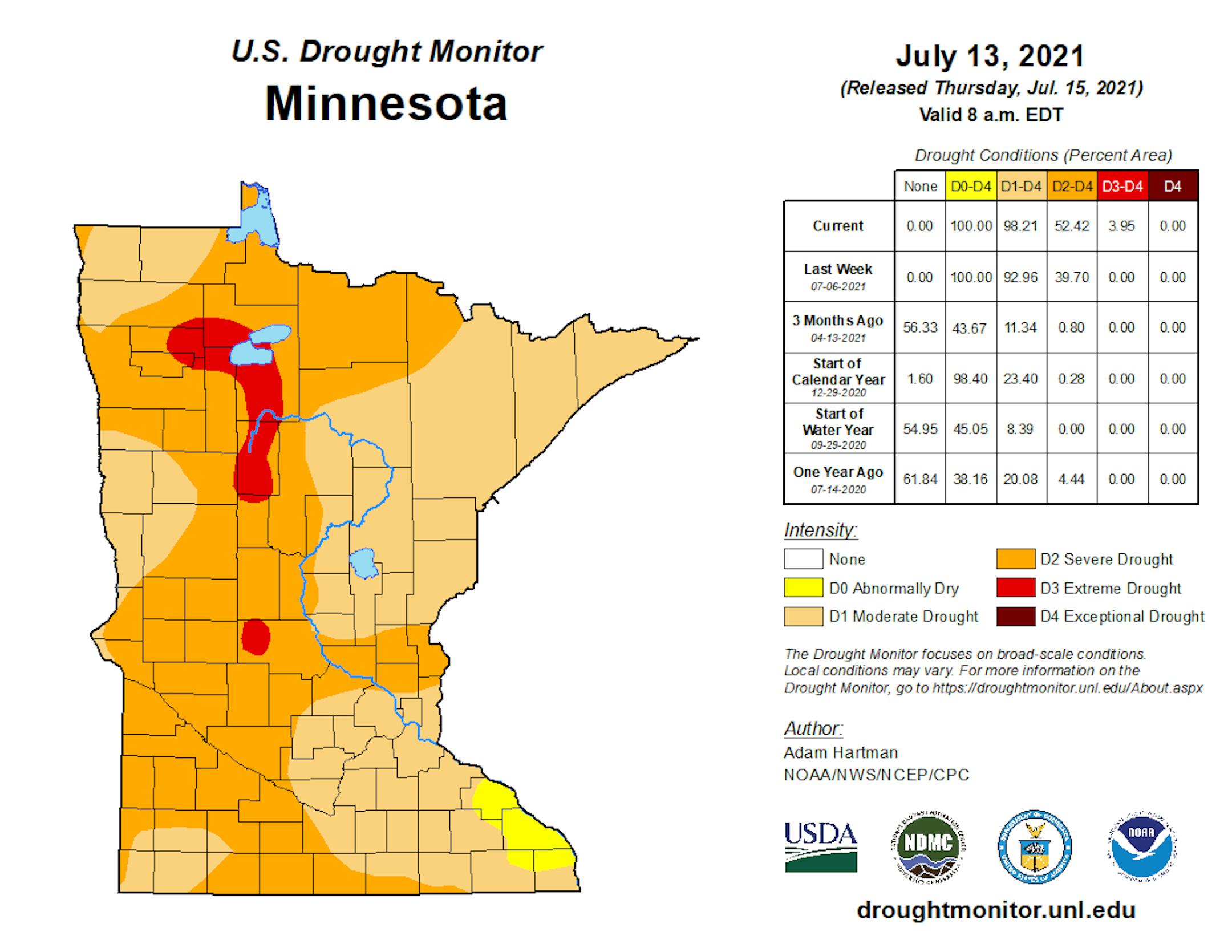
The latest Drought Monitor was released on Thursday... and it continues to not be good news for the region. Drought expanded across the state once again, and for the first time since April 2013 we have areas of Minnesota under Extreme (D3) drought (4% of the state) - the second to worst category. Almost the entire state (98.2%) is now under Moderate Drought (the exception being in southeastern portions of the state), and 52.4% is under Severe Drought.

(The Minnesota Star Tribune)

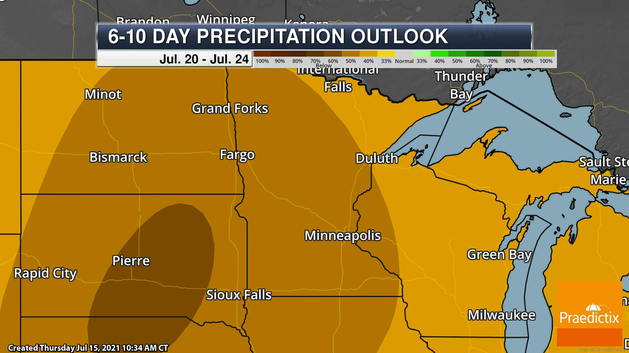
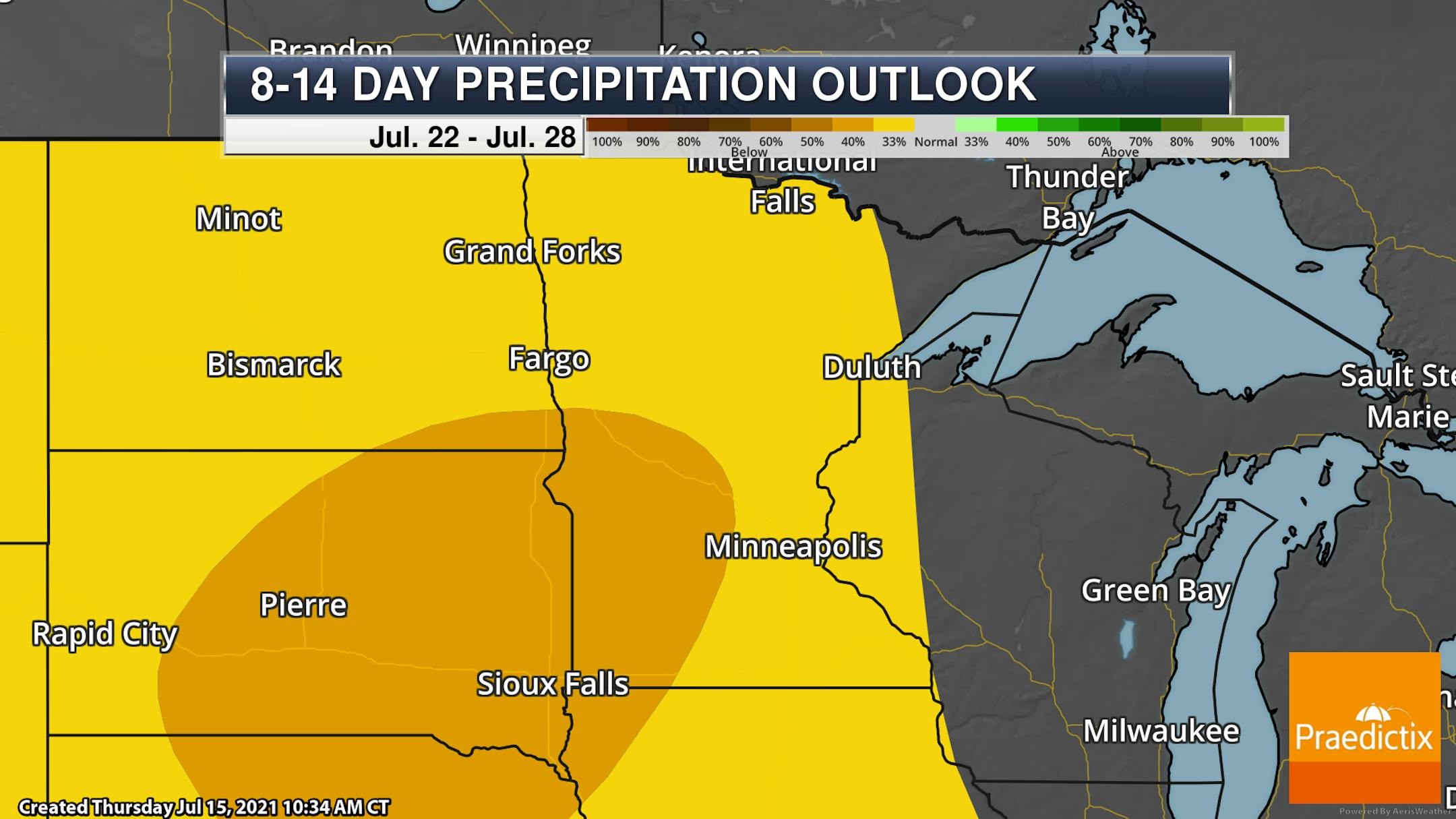
Looking at the Climate Prediction Center's 6-10 day and 8-14 day precipitation outlooks, it continues to look quite dry across the region throughout much of the rest of July with odds favoring below-average precipitation. Hopefully, your lawn got some rain Wednesday!

_______________________________________________

Air Quality Alert Into Friday Morning

(The Minnesota Star Tribune)

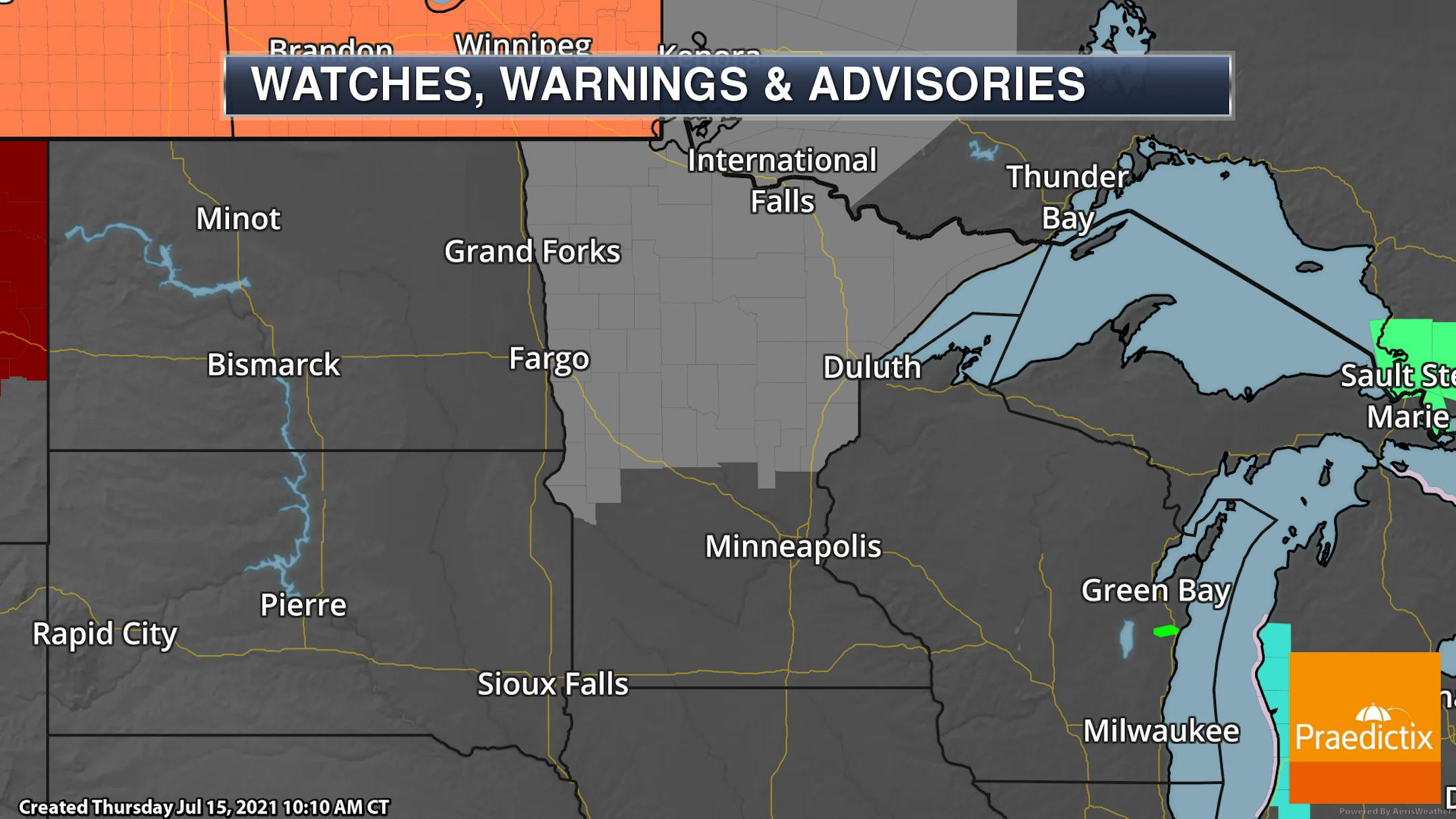
An Air Quality Alert continues across northern Minnesota through 9 AM Friday due to wildfire smoke from Canada that has moved southward into the state. At times, visibility will be reduced due to the smoke in the air and air quality values are expected to be in the unhealthy for all category. You can read more from the Minnesota Pollution Control Agency on the Air Quality Alert by clicking here.

_______________________________________________

Friday Weather Outlook

(The Minnesota Star Tribune)

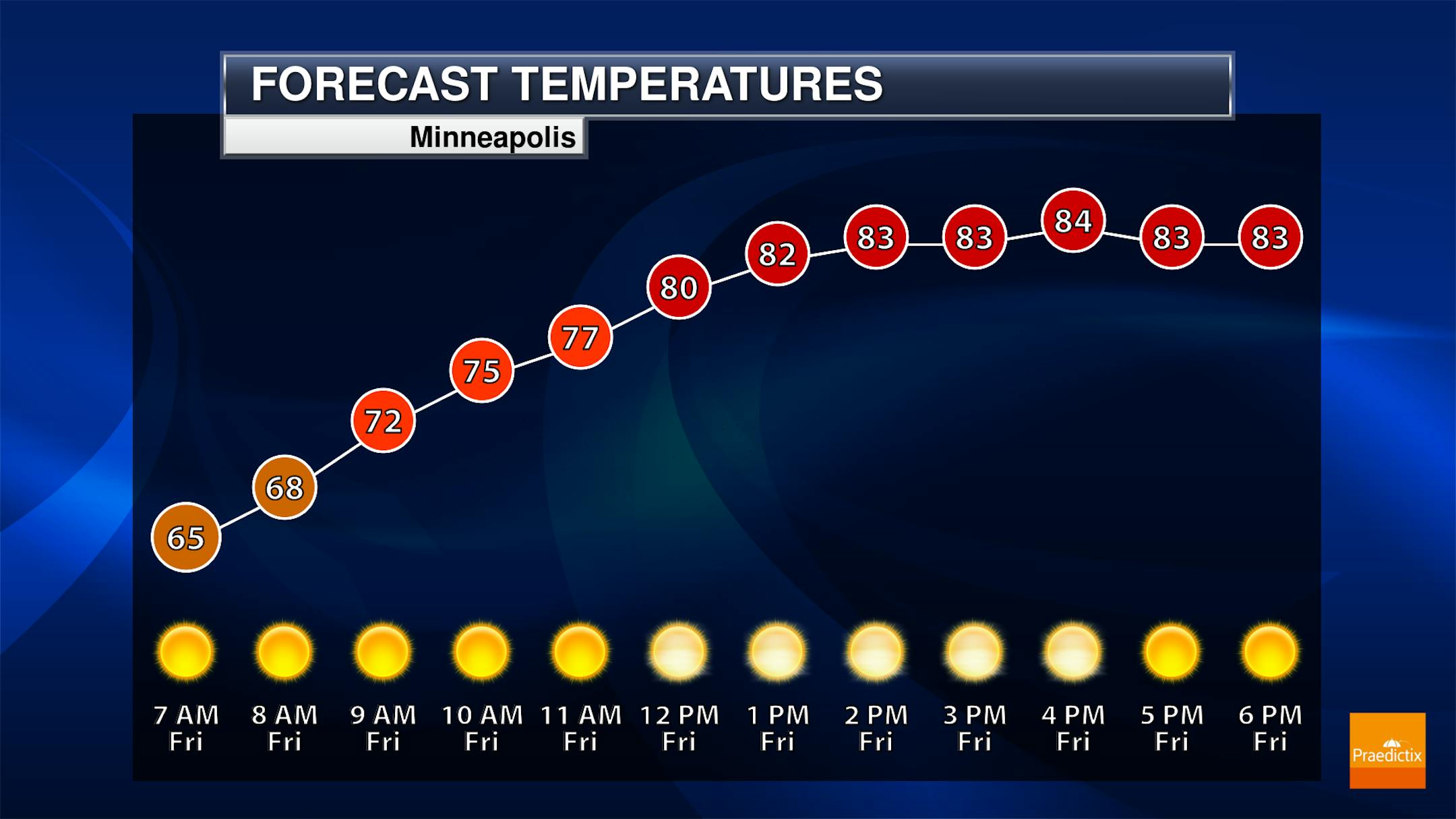
We'll see hazy, sunny skies to end the work week in the Twin Cities with morning temperatures bottoming out in the 60s before climbing to the mid-80s for highs in the afternoon.

(The Minnesota Star Tribune)

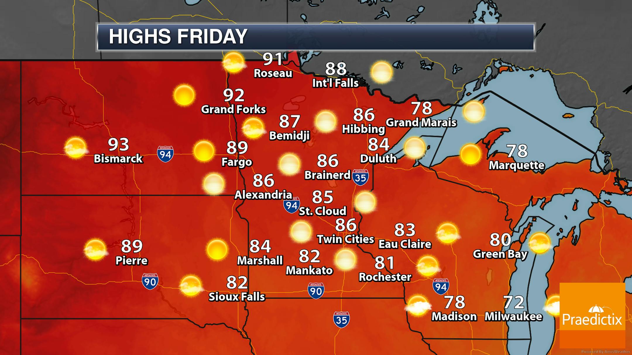
Looking statewide, sunny but hazy skies are expected courtesy of wildfire smoke filtering out of Canada. The warmest highs will be in northwestern Minnesota where some will reach the low 90s. 80s are expected in most other locations, but some areas of the North Shore may top off in the upper 70s.

_______________________________________________

Warm Weekend Ahead

(The Minnesota Star Tribune)

We're expecting much of the same as we head into the third weekend of July with mainly sunny skies (potentially hazy at times due to that wildfire smoke) and highs in the mid to upper 80s. While the graphic above shows 86F for Sunday, I think we will be closer to 90F.

_______________________________________________

Warmth Continues Next Week

(The Minnesota Star Tribune)

Warm temperatures continue into next week, with a stretch of 90s expected in the Twin Cities. The good news is that humidity values look to be high enough to help mitigate fire threats (even though we won't see any rain the next several days) but low enough to help prevent Heat Advisories.

(The Minnesota Star Tribune)

The warmest weather early next week will be out in western/northwestern Minnesota, where highs could climb into at least the mid-90s. Record/near-record heat will be possible Monday at the Baudette and Hibbing NWS climate locations, and on Tuesday in Grand Forks and Hibbing.

(The Minnesota Star Tribune)

And looking at the Climate Prediction Center's 6-10 day and 8-14 day temperature outlook, odds favor above-average temperatures throughout much of the rest of July here in the upper Midwest, including Minnesota.

_______________________________________________

Fickle Rainfall Patterns - More Heat Coming
By Paul Douglas

Trying to predict the unpredictable is why meteorologists often wind up at the isobar after work.

More than 1 in 5 Minnesotans live in Hennepin County; 607 square miles of cities, suburbs, lakes, forests & farmland. Summer rainfall patterns are especially maddening, with hit or miss showers and storms. Exhibit A: Wednesday. Plymouth picked up 3.6 inches of rain while MSP International saw a meager .22 inches. Northwest Hennepin county was swamped with 10-15 times more rain than southeast Hennepin county! Deep sigh.

Today's satellite image resembles a dirty ashtray. White cloud tops are stained brown and gray from hundreds of wildfires upwind of Minnesota; air quality alerts are posted for the northern half of the state.

Enjoy relatively comfortable weather the next few days because weather models show a surge of 90s returning next week. 100-degree heat can't be ruled out south and west of MSP within a week or so.

Hot. Sunny. T-storms in short supply? I fear Minnesota's drought will get worse.

_______________________________________________

Paul's Extended Twin Cities Forecast

FRIDAY: Warm, smoky sunshine. Wake up 63. High 84. Chance of precipitation 0%. Wind E 5-10 mph.

SATURDAY: Hazy sunshine. Wake up 64. High 86. Chance of precipitation 0%. Wind SE 5-10 mph.

SUNDAY: Hot sunshine. Wake up 67. High 88. Chance of precipitation 0%. Wind SE 5-10 mph.

MONDAY: Blue sky. Yes "it's hot enough for me". Wake up 69. High 90. Chance of precipitation 10%. Wind SW 8-13 mph.

TUESDAY: T-storms north. Hot sunshine. Wake up 70. High 92. Chance of precipitation 20%. Wind SW 5-10 mph.

WEDNESDAY: Simmering sunshine. Wake up 71. High 93. Chance of precipitation 10%. Wind SW 10-15 mph.

THURSDAY: Shocker: more hot sunshine. Wake up 71. High 92. Chance of precipitation 10%. Wind E 5-10 mph.

_______________________________________________

Minneapolis Weather Almanac And Sun Data
July 16th

(The Minnesota Star Tribune)

*Length Of Day: 15 hours, 13 minutes and 43 seconds
*Daylight LOST Since Yesterday: 1 minute and 41 seconds

*When Do We Drop Below 15 Hours Of Daylight? July 24th (14 hours, 58 minutes, and 22 seconds)
*When Is The Sunrise At/After 6 AM?: August 2nd (6:00 AM)
*When Is The Sunset At/Before 8:30 PM?: August 7th (8:30 PM)

_______________________________________________

This Day in Weather History
July 16th

2006: A heat burst occurs over west central and central Minnesota. The temperature at Canby jumped from 91 degrees to 100 degrees in 40 minutes from 10:35pm to 11:15pm. At the same time the dew point temperature dropped from 63 to 32 degrees. Heat bursts are caused by dying thunderstorms with very warm air aloft.

1963: A downpour falls at St. Charles, where half a foot of rain accumulates in one day.

_______________________________________________

National Weather Forecast

(The Minnesota Star Tribune)

A frontal boundary Friday from the Northeast to the Central Plains will bring the threat of showers and thunderstorms. Storms will also be possible in the Southeast and into the Four Corners region.

(The Minnesota Star Tribune)

The heaviest rain from Thursday through Saturday will be from the Ohio Valley into the central Plains, where some locations could see over 3" of rain.

_______________________________________________

Dozens killed in flooding caused by rainfall 'not seen in 100 years' in Europe

More from CNN: "At least 46 people have died due to severe flooding in western Europe, caused by what experts described as the heaviest rainfall in a century. Up to 70 people are missing in Germany after flash floods swept across western and southern parts of the country, causing buildings to collapse, police said Thursday. Germany is worst hit with 40 people killed, while six people died in Belgium. Luxembourg and the Netherlands are also affected. ''In some areas we have not seen this much rainfall in 100 years,'' Andreas Friedrich, a German weather service (DWD) spokesman, told CNN. He added that "in some areas we've seen more than double the amount of rainfall which has caused flooding and unfortunately some building structures to collapse.''"

Massive Tsunami From Dino-Killing Asteroid Carved 'Megaripples' Into the Ocean Floor

More from Gizmodo: "The asteroid that killed off all non-avian dinosaurs made quite the splash when it hit the Yucatan Peninsula some 66 million years ago, generating a tsunami of epic proportions. Seafloor scars from this gigantic wave have been spotted in seismic data taken in Louisiana, offering new insights into this catastrophic event. The megatsunami produced by the Chicxulub impact left a lasting mark on the seafloor, according to new research published in Earth and Planetary Science Letters and led by geophysicist Gary Kinsland from the University of Louisiana at Lafayette. The analysis suggests the wave caused the formation of "megaripples" along the bottom. These megaripples are now buried deep underground, but their existence is further confirmation of the power unleashed by the asteroid on that fateful Late Cretaceous day."

The Amazon rainforest is officially creating more greenhouse gases than it is absorbing

More from LiveScience: "Forests absorb huge amounts of carbon dioxide (CO2) from Earth's atmosphere, making them a key part of mitigating climate change. But humans may have already rendered the world's largest rainforest useless in — and perhaps even detrimental to — the battle against greenhouse gases, a new study finds. According to the study, published July 14 in the journal Nature, the Amazon rainforest is now emitting more than 1.1 billion tons (1 billion metric tons) of CO2, a greenhouse gas, a year, meaning the forest is officially releasing more carbon into the atmosphere than it is removing. The carbon balance tipped due to "large-scale human disturbances" in the Amazon ecosystem, the researchers wrote in their study, with wildfires — many deliberately set to clear land for agriculture and industry — responsible for most of the CO2 emissions from the region. These fires also reinforce a feedback loop of warming, the team found, with more greenhouse gases contributing to longer, hotter dry seasons in the Amazon, which lead to more fires and more CO2 pollution."

_______________________________________________

Thanks for checking in and have a great day! Don't forget to follow me on Twitter (@dkayserwx) and like me on Facebook (Meteorologist D.J. Kayser).

- D.J. Kayser

(The Minnesota Star Tribune)

about the writer

D.J. Kayser

See More