

Massive Snow Melt This Week
Hard to believe that it was about a week ago that parts of the Twin Cities metro picked up more than 1 foot of snow. Some of the heaviest amounts reached 20" near St. Paul! 2 to 3 days later, most of the snow had all but melted thanks to record high temperatures and heavy rain on Wednesday.


Unique Storm of December 15, 2021:
"The storm system that crossed over Nebraska, Iowa, Minnesota, Wisconsin and Illinois over December 15-16 was almost totally unique in many of its atmospheric attributes. Hundreds of temperature and dew point records were set with the rapid transport of heat and moisture from the south. The wind structure of the atmospheric layers supported record-setting wind speeds, as well as producing 25 reports of tornadoes (12 in NE, 13 in IA), and three suspected reports of tornadoes in MN, yet to be verified. Though fast moving, the storm system produced some record-setting rainfall amounts as well. Among the most rare and unique measurements of the storm were: confirmed tornadoes on the ground near Lewiston (Winona County) and Hartland (Freeborn County), the first ever observed such storms in Minnesota during the month of December; a radiosonde (balloon) measured precipitable water measurement from the Twin Cities (integrated water vapor content in the atmosphere overhead) of 1.23inches, the highest measurement ever made in Minnesota during the months of December, January, and February; a dew point measurement at MSP airport of 55°F, the highest historical dew point measurement historical for the Twin Cities between December 6th and March 6th; a maximum temperature reading of 66°F at Caledonia, Winona, and Austin, all-time statewide record high for this time of year, and about 30-35 degrees F above normal."
Storm Summary For Central US Extreme Wind Event
"Here is a brief look at both the estimated and observed maximum wind gusts across the central U.S. for the 24 hour period ending 9 am CT. For a more detailed list, visit WPC's storm summary (https://wpc.ncep.noaa.gov/discussions/nfdscc5.html…). Local NWS forecast offices will have more information as well."

Quiet Weekend Ahead; Light Snow Tuesday
After a little light snow Friday night, the rest of the weekend will be colder and quiet. Our next chance of light snow moves through the northern half of the state on Tuesday with some minor snow accumulations.

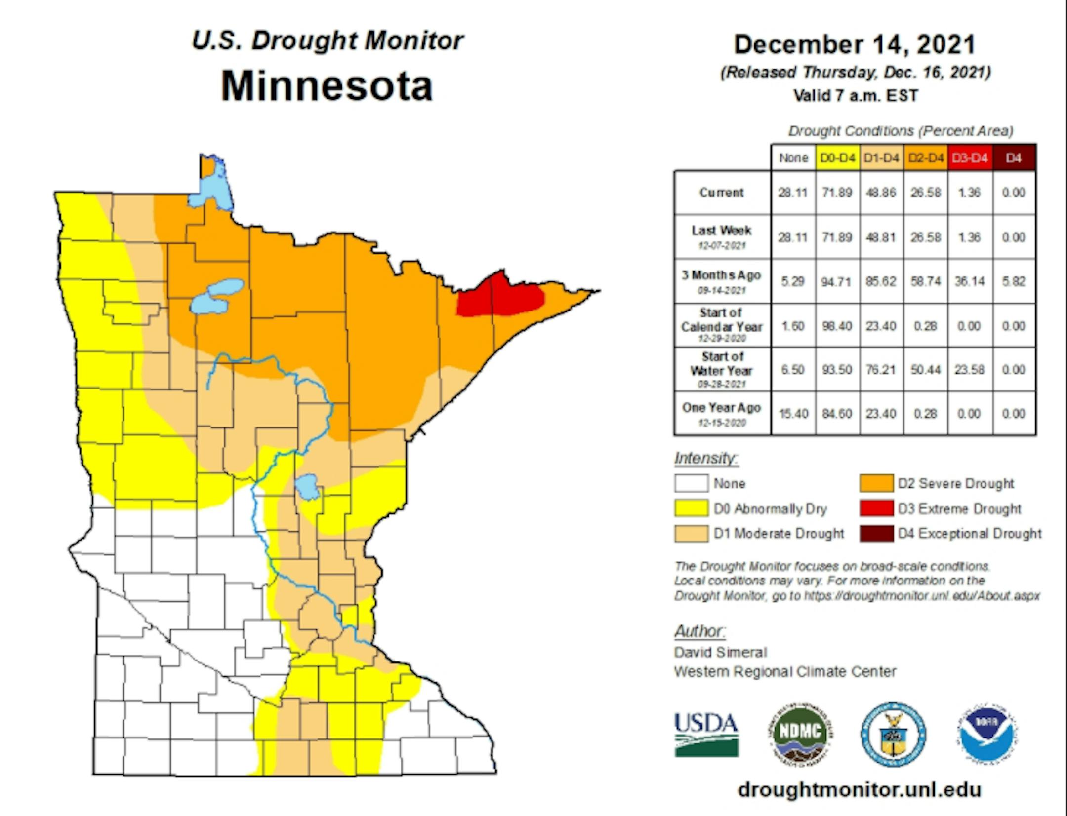
Drought Update For Minnesota
According to the US Drought Monitor, nearly 1% of the state is still considered to be in an extreme drought (in red across northern Minnesota), which is down from nearly 36% from 3 months ago. There has been a slight improvement in Severe Drought, which is at 27%, down from 59% 3 months ago. Nearly 49% of the state is still under a Moderate Drought, which includes much of the Twin Cities Metro.
Precipitation Departure From Average Since January 1st
Here's a look at the precipitation departure from average since January 1st and note that most locations are still several inches below average, including the Twin Cities. The MSP Airport is still -5.65" below average since January 1st, which is the 56th driest January 1st - December 16th on record.

Saturday Weather Outlook
Here's the weather outlook for Minneapolis on Saturday. Areas of light snow will lingering through the morning hours, but skies will gradually clear through the day with with a high temp warming into the lower 20s, which will be nearly -5F to -10F below average for mid December.


