10 Years Later: The June 19-20, 2012, Historic Flood
"Overview - In the week leading up to the flooding rains of June 19 th -20 th , parts of northeast Minnesota had received 2-4 inches of rain as numerous storm systems moved across the area. This helped to saturate the soil which primed the Duluth area for runoff in the extreme rain event that followed. On Tuesday, June 19 th , a cold front that had moved through the previous day began to return north as a warm front and became stationary just south of Duluth. This front helped provide continuous lift for thunderstorms that developed over east-central Minnesota and then tracked northeast into the Duluth area along with the North Shore of Lake Superior and into northwestern Wisconsin. The official rainfall in Duluth on the 19 th was 4.14 inches. The thunderstorms finally ended when a strong cold front moved through during the afternoon of Wednesday, June 20 th , but not before dumping another 3.11" at the airport. The official Duluth total rainfall for the event was 7.25". Duluth International Airport broke several rainfall records during this flooding event. Locally higher amounts in the 8-10 inch range were reported throughout Duluth neighborhoods and along the North Shore of Lake Superior."

Excessive Heat Through Monday
EXCESSIVE HEAT WARNING IN EFFECT UNTIL 1 AM CDT TUESDAY...
* WHAT...Dangerously hot conditions with heat index values up to 100 this afternoon and 106 Monday afternoon, with overnight lows only dropping to around 80.
* WHERE...The Twin Cities metro area and west central Minnesota.
* WHEN...From 1 PM this afternoon to 1 AM CDT Tuesday.
* IMPACTS...Extreme heat and humidity will significantly increase the potential for heat related illnesses, particularly for those working or participating in outdoor activities.
* ADDITIONAL DETAILS...The heat may also result in some roads buckling.
Drink plenty of fluids, stay in an air-conditioned room, stay out of the sun, and check up on relatives and neighbors. Young children and pets should never be left unattended in vehicles under any circumstances. Take extra precautions if you work or spend time outside. When possible reschedule strenuous activities to early morning or evening. Know the signs and symptoms of heat exhaustion and heat stroke. Wear lightweight and loose fitting clothing when possible. To reduce risk during outdoor work, the Occupational Safety and Health Administration recommends scheduling frequent rest breaks in shaded or air conditioned environments. Anyone overcome by heat should be moved to a cool and shaded location. Heat stroke is an emergency! Call 9 1 1.

Hourly Feels Like Temps Monday
Here's the hourly feels like temp for Minneapolis on Monday. Heat index values will quickly warm into the 90s by mid-morning and into the 100s by late afternoon and possibly as high as 106F.

Severe Threat PM Monday
According to NOAA's Storm Prediction Center there is a Marginal Risk of severe storms has been issued late Monday for the potential of a few strong storms across the region with gusty winds and hail as the primary threats.

Hot Monday With PM Storms
Here's the weather outlook from 7AM Monday to 7AM Tuesday, which shows fairly quiet conditions through much of the day. A frontal boundary will be responsible for a few strong to severe storms late in the day Monday with wind and hail as the primary concerns. There could also be a few pockets of heavy rainfall.

Precipitation Potential Through Next Week
Here's the extended rainfall potential through the end of the week. There will be a few areas of rain Monday night. There also appears to be a chance of showers and storms later in the week and potentially the upcoming weekend. Stay tuned...

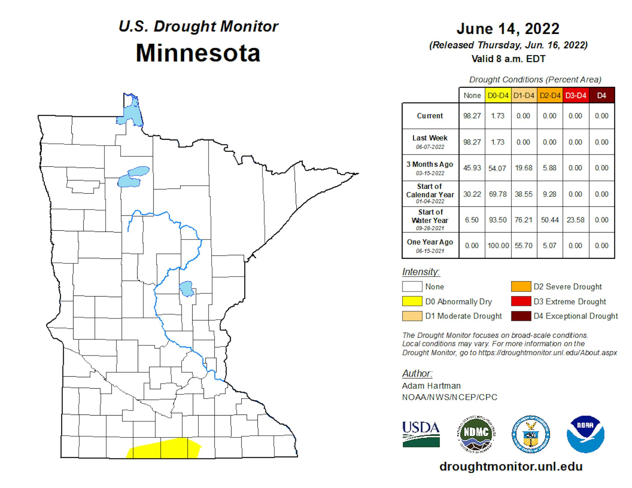
Minnesota Drought Update
Thanks to above average precipitation so far this year, we've wiped out much of the drought that was in place to start the year. In fact, as of early January, nearly 10% of the state in northern Minnesota was considered in a severe drought. Now, only 3% of the state is considered to be abnormally dry.