Above Average Fair Weather Lasts All Week

Today brings more sunshine, less wind and temperatures a few degrees milder; kissing 80F by mid-afternoon with low humidity. We'll heat up close to 90F again by Labor Day Weekend. "Idalia" may hit the Gulf Coast of Florida north of Tampa as a tropical storm or hurricane Wednesday. Check the blog for more details. -Todd Nelson

August 27, 2023 at 2:30AM

Tropical Depression TEN From Saturday

The National Hurricane Center starting issuing advisories for Tropical Depression TEN midday Saturday for a wave that was located just east of the Yucatan Peninsula. This storm will continue to lift northeast over the next few days and will likely intensify before making landfall along the Florida coastline as Tropical Storm or a Hurricane "Idalia" around midweek.

Tracking the Tropics (NOAA Satellite/The Minnesota Star Tribune)

Tracking the Tropics

This system is expected to drift north into the Gulf of Mexico, which intensifying into "Idalia" and could possibly be a hurricane before making landfall in Florida around midweek.

Tracking the Tropics (NOAA NHC/The Minnesota Star Tribune)
Model Guidance (Tropical Tidbits/The Minnesota Star Tribune)

Heavy Rainfall Ahead

Regardless of how strong this storm gets, heavy rain will be one of the main concerns here. Widespread 3" to 6" or more will be possible from Florida through the Mid-Atlantic States, which could be problematic in terms of flooding.

Heavy Rainfall Potential (WeatherBell/The Minnesota Star Tribune)

Gusty Winds Expected

This system could potentially reach the Florida coastline as a Tropical Storm or a Hurricane with strong winds. There could be more issues along the Florida coastline as the storm intensifies and moves in midweek.

Wind Swath Through Next Week (WeatheBell/The Minnesota Star Tribune)

Active Weather in the Atlantic

As of midday Saturday, we had several disturbances ongoing in the Atlantic Basin, including Hurricane Franklin and Tropical Depression TEN.

7 Day Atlantic Outlook (NOAA NHC/The Minnesota Star Tribune)

Hurricane Franklin

Hurricane Franklin will continue to lift north in the Western Atlantic through midweek. This storm could briefly become a major category 3 storm as it slides northwest of Bermuda

Hurricane Franklin (NOAA NHC/The Minnesota Star Tribune)

Atlantic Basin Climatology

Our recent uptick in the Atlantic tropical activity coincides with climatology, which suggests that things ramp up pretty quickly during the 2nd half of August and into September. This is when the sea surface temperatures are typically the warmest in the Atlantic Basin. Note that the actual peak of the season is on September 10th, which is less than 3 weeks away. With that being said, the next several weeks could be pretty active in the Tropics.

Atlantic Hurricane & Tropical Storm Climatology (NOAA NHC/The Minnesota Star Tribune)

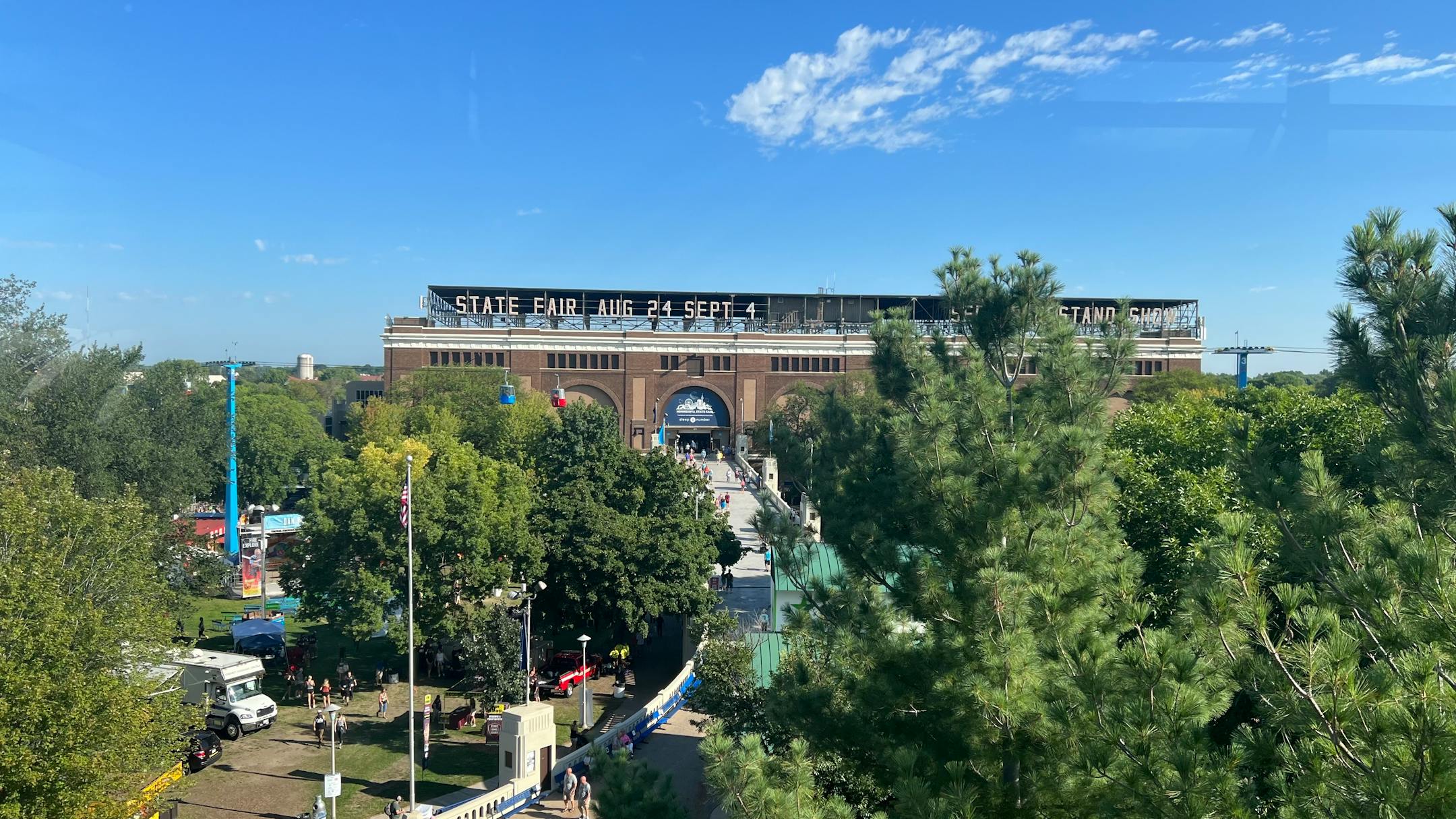
Minnesota State Fair Weather

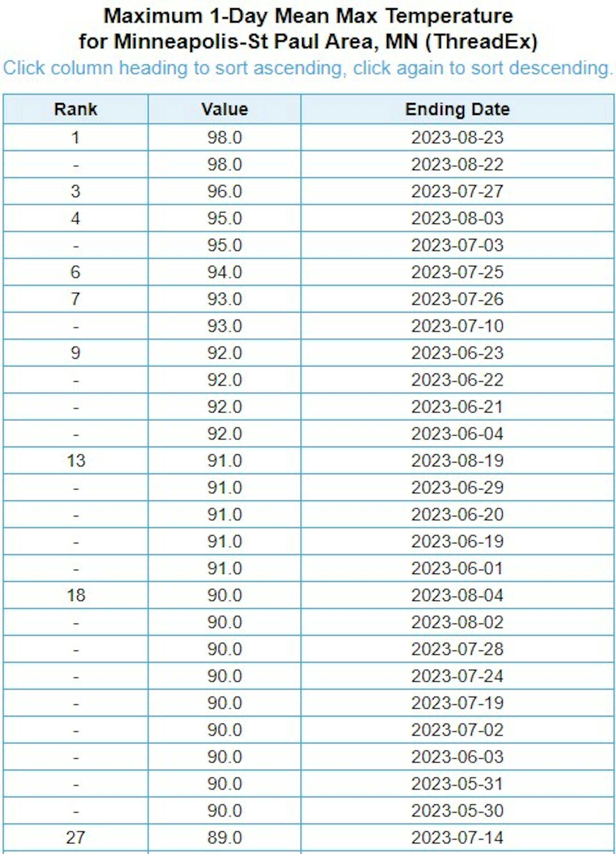
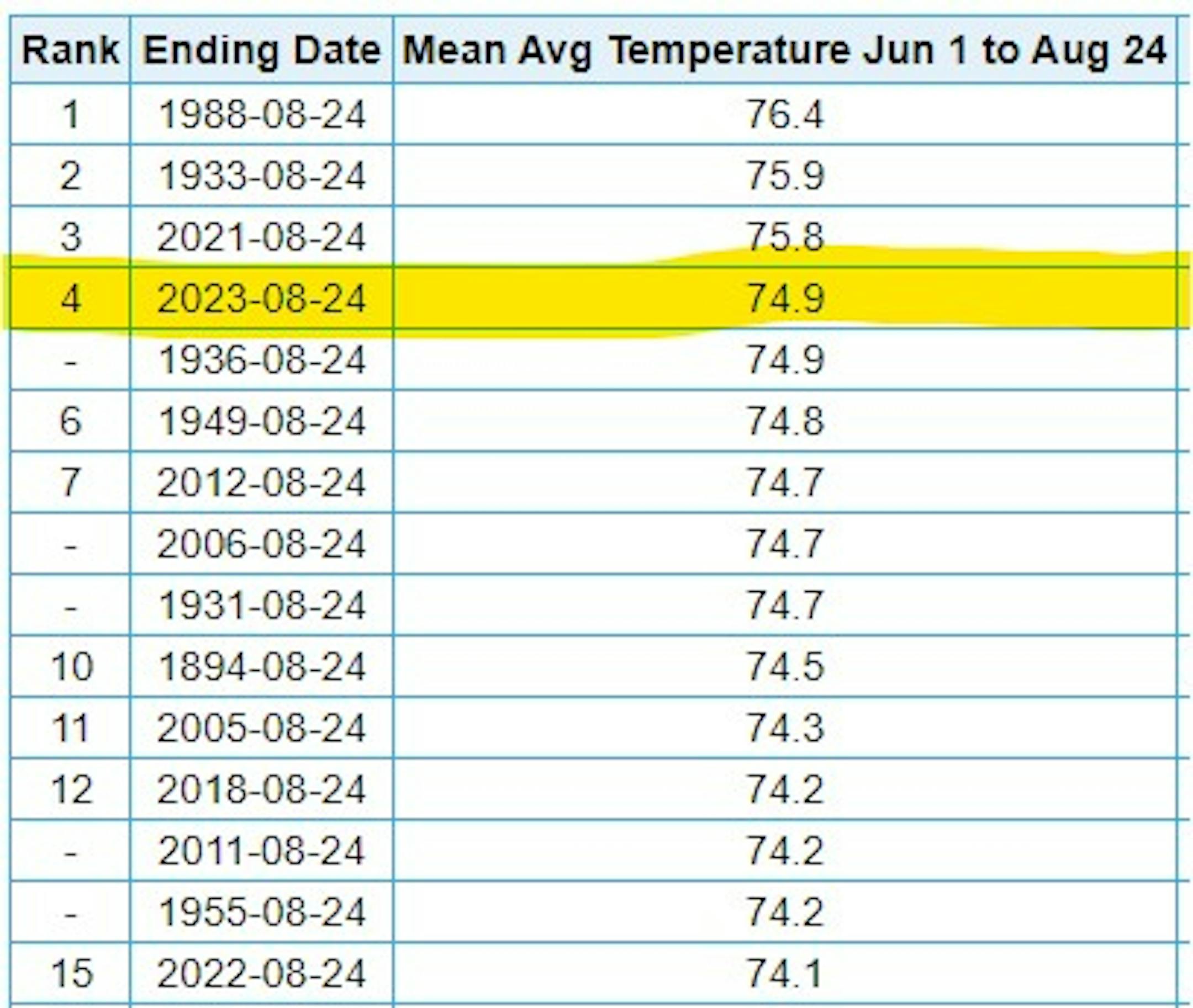
"It's time once again for the "Great Minnesota Get Together." Weather plays quite a role in the State Fair experience. Who doesn't remember braving the heat with the crowds on one of the busier intersections on a sweltering afternoon? A quick rain burst will send people scurrying for cover, and folks savor balmy days in the 70s with just a bit of a breeze. Below are some State Fair weather facts and notable weather events that have happened in past Minnesota State Fairs. Quick History of the Minnesota State Fair The Minnesota State Fair has been held at its current site since 1885. Before that it was held at a variety of locations including Fort Snelling. There were some years when the Fair was not held because of war, disease, or for logistical reasons. These years are: 1861 (Civil War), 1862 (Civil and Indian War), 1893 (Columbian Exposition), 1945 (fuel shortage because of WWII), and 1946 (outbreak of Polio.) In 2020 the fair was not held due to COVID 19. Beginning in 1975, the fair has a 12-day run each year ending with Labor Day. Thus since 1975, the Fair begins on a Thursday in August. Before 1975, the Fair was held for shorter durations (eleven days from 1972 to 1974, ten days from 1939 to 1971, eight days from 1919 to 1938 and six days from 1885 to 1918). The 2023 Minnesota State Fair runs from August 24-Sepember 4."

Minnesota State Fair on Friday (@DKayserWX/The Minnesota Star Tribune)

Hottest Days of 2023 So Far

The hottest days of 2023 (so far) were back to back on August 22nd and 23rd, when the MSP hit 98F and heat index values peaking around 110F to 120F around the metro. Uffda! Through Friday, August 25th, there have been (27) 90F days this year and tied for the 13th most number of 90F days in any year.

Hottest Day of 2023 So Far (NOAA NWS/The Minnesota Star Tribune)

4th Hottest Meteorological Summer on Record

It has also been a hot summer with readings running well above average since June 1st and good enough for the 4th hottest Meteorological Summer on record so far (through August 24thth). Note that 2021 was the 3rd hottest and 2022 was the 15th hottest. Meteorological Summer ends next Thursday.

4th Hottest Summer on Record at MSP (NOAA NWS/The Minnesota Star Tribune)

Average Number of 90F Days At MSP

Looking at the last 30 years, the average number of 90F days at the MSP Airport is (14). July is the hottest month with an average of (6) 90F days. This year we've had (23) 90F days, last year we had (18) days in the 90s and in 2021 there were (27) days in the 90s. The most number of 90F days in any single year was (44) set in 1988.

Average Number of 90F Days At MSP (NOAA NWS/The Minnesota Star Tribune)

11th Driest Meteorological Summer on Record

It has been very dry across much of the region so far this summer with only 5.79" of rain falling at the MSP Airport since June 1st. Interestingly, we're still -6.45" below average this summer. For reference, the driest on record was only 1.73" set in 1894. Interestingly, the summers of 2021 and 2022 were just about as dry as this year has been.

11th Wettest Summer on Record (NOAA NWS/The Minnesota Star Tribune)

90 Day Precipitation Anomaly

On average, the wettest time of the year is in the summer, with the months of June, July and August seeing nearly 13" of rain at the MSP Airport. If we take a look at the 90 day precipitation anomaly, which dates back to about mid May, some locations are nearly -3.00" to nearly -7.00" below average (in red/pink). Note that some locations across southeastern Minnesota are nearly -8.00" to -10.00" below average.

90 Day Precipitation Anomaly (WeatherBell/The Minnesota Star Tribune)

Drought Update

Drought continues across much of the state with a slight uptick in the Severe and Extreme categories. The greatest increase was in the Severe (D3) category, which increase nearly 11% from last week.

MN Drought Update (US Drought Monitor/The Minnesota Star Tribune)

Extended Precipitation Outlook

It is still plenty dry across the state and the extended precipitation forecast doesn't show much in terms of any significant soakings anytime soon. There could be a little here and there over the next 7 days, but not enough to help any of the drought conditions.

Extended Precipitation Outlook (WeatherBell/The Minnesota Star Tribune)

Twin Cities Weather Outlook For Sunday

The weather outlook for the Twin Cities on Sunday, August 27th will be comfortable once again with highs approaching 80F in the afternoon with a little more sunshine than we had yesterday. Overall, it'll be very nice day with comfortable dewpoints in the mid/upper 50s through the day - Enjoy!

Twin Cities Weather Outlook For Sunday (Praedictix/The Minnesota Star Tribune)
Hourly Dewpoint Forecast For Minneapolis on Sunday (Praedictix/The Minnesota Star Tribune)

Meteograms For Minneapolis

Weather conditions for Minneapolis through the day Sunday will be very comfortable. Temps will start in the upper 50s in the morning and top out in the upper 70s in the afternoon with partly cloudy skies. Winds will turn more southerly in the afternoon around 10mph.

Hourly Temps & Sky Conditions For Minneapolis on Sunday (Praedictix/The Minnesota Star Tribune)
Hourly Wind Gusts & Direction For Minneapolis on Sunday (Praedictix/The Minnesota Star Tribune)

Weather Outlook For Sunday

Temps on Sunday will be a little closer to average as we warm into the 70s to near 80F across the state. Skies will be sunny to partly cloudy with comfortable dewpoints and no weather drama.

Sunday Weather Outlook (Praedictix/The Minnesota Star Tribune)
Highs From Average on Sunday (Praedictix/The Minnesota Star Tribune)

Extended Temperature Outlook For Minneapolis

The 5 day temperature outlook for Minneapolis will remain pretty comfortable over the next several days with readings warming into the 70s to near 80F, which will be closer to and slightly above average for this time of the year.

5 Day Temperature Outlook For Minneapolis (Praedictix/The Minnesota Star Tribune)

More Comfortable Dewpoints.

The 5 day dewpoint forecast for Minneapolis looks quite a bit more comfortable than it was last week. It certainly won't be as sticky/tropical with readings generally holding in the 50s through next week.

5 Day Dewpoint Forecast For Minneapolis (Praedictix/The Minnesota Star Tribune)

Extended Weather Outlook For Minneapolis

Well that's more like it. The extended temperature forecast won't be nearly as hot as it was this week. Highs will warm into the 70s to near 80F through the middle part of next week with a slight uptick in temps as we approach the early part of September. Weather conditions will also be mostly dry over the next 7 days.

7 Day Weather Outlook For Minneapolis (Praedictix/The Minnesota Star Tribune)

Another Hot Week Shaping Up

According to NOAA's National Blend of Models, we'll have more comfortable conditions through the middle part of next week. However, we're noticing a bump upward as we approach early September. Readings could once again approach the 90F mark.

NBM Extended Temperature Outlook For Minneapolis (WeatherBell/The Minnesota Star Tribune)

Weather Outlook

Weather conditions in the Midwest look fairly quiet over the next several days with minimal precipitation chances through next weekend. The big story will be southeast of us, where a tropical system could develop and impact the Southeastern US with gusty winds and heavy rainfall.

National Weather Outlook Through Next Weekend (Tropical Tidbits/The Minnesota Star Tribune)

8 to 14 Day Temperature Outlook

According to NOAA's Climate Prediction Center, the 8 to 14 day temperature outlook shows Warmer than average temperatures across much of the nation as we head through the first week of September. The warmest weather will once again be found in the Southern US, where temps will remain well above average.

8 to 14 Day Temperature Outlook (NOAA CPC/The Minnesota Star Tribune)

8 to 14 Day Precipitation Outlook

According to NOAA's Climate Prediction Center, the Northwestern US looks a little more unsettled, while drier weather will settle in across the Central and Southern US.

8 to 14 Day Precipitation Outlook (NOAA CPC/The Minnesota Star Tribune)

Above Average Fair Weather Lasts All Week
By Paul Douglas

Yesterday I got my steps in at the Minnesota State Fair while clutching food with both greasy hands. Exercising with food - smart. Followed by a walk of shame to the newly renovated Ozempic booth, which was doing a brisk midday business. Maybe I dreamt that last part? Hmm. The weather felt like fall with clouds and a cool breeze; a non-issue for once.

Today brings more sunshine, less wind and temperatures a few degrees milder; kissing 80F by mid-afternoon with low humidity.

Here comes a quiet week with sunshine and 80s, a few degrees warmer than average. I still think we'll see a few 90s by Labor Day weekend, which sounds appropriate. The metro's 27 days at/above 90F will rise into the 30s by mid-September.

Hurricane season peaks in the coming weeks along with sea surface temperatures, and "Idalia" may hit the Gulf Coast of Florida north of Tampa as a tropical storm or hurricane Wednesday.

I'm heading back out to the fair today, and my wife will have me on a leash again. Hey wait, is that even legal?

Extended Forecast

SUNDAY: Partly sunny, pleasant. Winds: S 5-10. High: 79.

SUNDAY NIGHT: Partly cloudy and quiet. Winds: S 5. Low: 63.

MONDAY: Mix of clouds and sunshine. Winds: SW 8-13. High: 84.

TUESDAY: Plenty of sunshine, very nice. Winds: NW 10-15. Wake-up: 64. High: 83.

WEDNESDAY: Sunny with light winds. Winds: SE 5-10. Wake-up: 62. High 85.

THURSDAY: Sunny, breezy and warmer. Winds: S 10-20. Wake-up: 65. High 87.

FRIDAY: Hot sun, nighttime thunder? Winds: S 15-25. Wake-up: 71. High 92.

SATURDAY: Becoming sunny and lake-worthy. Winds: NW 8-13. Wake-up: 72. High: 89.

This Day in Weather History

August 27th

1992: A chilly night in Embarrass, where the temperature dips to 28 degrees.

Average High/Low for Minneapolis

August 27th

Average High: 79F (Record: 99F set in 1926)

Average Low: 61F (Record: 42F set in 1887)

Record Rainfall: 2.80" set in 1978

Record Snowfall: NONE

Twin Cities Almanac For August 27th (Praedictix/The Minnesota Star Tribune)

Sunrise/Sunset Times for Minneapolis

August 27th

Sunrise: 6:29am

Sunset: 7:59pm

Hours of Daylight: ~13 hours & 30 minutes

Daylight LOST since yesterday: 2 Minutes & 57 Seconds

Daylight LOST since Summer Solstice (June 21st): ~ 2 Hour & 7 Minutes

Moon Phase for August 27th at Midnight

2.8 Days Until The Full "Blue" Moon

"Aug. 30 at 8:36 p.m. CDT - The second full moon occurring within a calendar month is usually bestowed this title. Although the name suggests that to have two Full Moons in a single month is a rather rare occurrence (happening "just once in a . . . "), it actually occurs once about every three years on average. There is actually a second and more arcane definition of a Blue Moon, apparently conceived by an almanac editor based in Maine back in the 1930s, but we will not get into this here. In addition, the moon will also be at perigee at 12:00 p.m. EDT., at a distance of 221,942 miles (357,181 km) from Earth. Very high tides can be expected from the coincidence of perigee with full moon (referred to as an astronomical spring tide). Finally, a full moon occurring very late in August or very early in September is sometimes bestowed with the title of Fruit Moon or Barley Moon. This will be the case with this second August full moon in 2023."

Moon Phase For August 27th at Midnight (The Minnesota Star Tribune)

National High Temps on Sunday

Temperatures on Sunday will be extremely hot across the Southern US with highs running nearly +5F to +15F above average. Widespread records will be found the Gulf Coast States through Sunday before slightly cooler air moves in around midweek. Cooler weather will settle in across the Midwest with readings at or slightly below average for a change.

National Weather Outlook For Sunday (Praedictix/The Minnesota Star Tribune)
National Highs From Average on Sunday (Praedictix/The Minnesota Star Tribune)

National Weather Sunday

The weather outlook on Sunday will be a little unsettled across the Central US along a boundary that will separate the extreme heat in the Southern US from the more comfortable air mass farther north. Along this boundary, scattered showers and storms will be possible, some of which could be strong to severe with locally heavy rainfall.

National Weather Map For Sunday (Praedictix/The Minnesota Star Tribune)

National Weather Outlook

The weather outlook through Monday looks a little unsettled across parts of the Central and Southern US. Some of the storms could be a little on the strong side with locally heavy rains. We're also keeping an eye on a tropical system developing in the Gulf of Mexico that could make landfall in Florida around midweek as a Tropical Storm or Hurricane. Stay tuned...

Weather Outlook Through Monday (NOAA WPC/The Minnesota Star Tribune)

Extended Precipitation Outlook

The extended precipitation outlook shows areas of heavy rainfall across the southeastern US with a potential tropical system developing through early next week.

Extended Precipitation Outlook (NOAA WPC/The Minnesota Star Tribune)

Climate Stories

(NOAA/The Minnesota Star Tribune)

"Years After the Blob, the Pacific Still Doesn't Look the Same"

"In late 2013, a mass of warm water now known as the Blob appeared in the northeast Pacific—a massive marine heatwave that cooked coastal ecosystems from Alaska to California. Later, bolstered by an El Niño, the vast and potent heatwave wreaked havoc on marine ecosystems: thousands of seabirds died, while blooms of harmful algae poisoned marine mammals and shellfish. The suddenly warmed water also brought an influx of new animals to the northeast Pacific: ocean sunfish appeared in Alaska, while yellow-bellied sea snakes popped up in Southern California. By 2017, the Blob had waned and many of these more tropical species had retreated. Yet not all. Some of the species that colonized new habitats during the heatwave have stuck around. And now, says Joshua Smith, a marine ecologist at the Monterey Bay Aquarium in California who documented in new research how the Blob triggered a range of subtle yet persistent shifts in the spread of marine species, "I'm starting to sort of question whether those communities will ever look the way they did."

"Climate change is coming for your olive oil, too"

"Inflation is finally easing. Americans are paying less for gas than they were a year ago. Furniture, television, and airfare prices have all fallen since last summer. Even the used car market is cooling off after its meteoric rise. But one unsuspecting staple in many American kitchens has become a prominent outlier: olive oil. The price of the already pricey liquid fat has soared to a record high this summer. It's the latest chapter in the annals of heatflation — when scorching temperatures harm crops and push food prices up. A yearlong drought and a spring of extreme heat in Spain, the world's largest olive oil producer, devastated the country's olive groves. Spanish olive oil production fell by a half — from an estimated 1.3 million to 610,000 metric tons — over the past year. Now fears are mounting over the very real possibility that the country's inventory will run out before the next harvest begins, in October."

"It's So Hot, Congress May Actually Pass a Law About It"

"What are we going to do about the heat? As devastatingly hot as this summer has been — and it has broken records and likely killed thousands of Americans — next summer will almost certainly be worse. Will Congress act? New federal legislation to attack the root of the problem by reducing carbon emissions isn't on the table, thanks to Republican control of the House. But that doesn't mean there's zero chance of any kind of heat legislation emerging this year. Republicans have proven open to funding ideas like better hurricane forecasting, the streamlining of flood insurance claims, and more seawalls — all things that get lumped into the category of adaptation to extreme weather or resilience. Could something similar be possible for heat? A handful of bills have been introduced — almost all by Democrats — that seek to adapt to heat in one way or another. Because adapting to hotter temperatures isn't as simple as erecting new levies, all the legislation seeks in one way or another to ensure everyone has access to a cooler environment. That might mean giving people money to keep their air conditioners running, funding cooling centers, or building shade outside."

Thanks for checking in and don't forget to follow me on Twitter @TNelsonWX

@TNelsonWX (The Minnesota Star Tribune)
about the writer

about the writer

Todd Nelson

See More