

Midweek Storm System
"There is growing potential for an impactful prolonged weather event across all of Minnesota and Wisconsin Tuesday afternoon through Thursday afternoon. There looks to be a variety of precipitation types, mainly rain and snow but possibly pockets of freezing rain or sleet. There will also be potential for accumulating snow and breezy conditions during the latter stages of this system. There are still many uncertain pieces of the forecast with this system, including the track and timing which would determine specific impacts, so please continue to monitor trusted sources for the latest forecasts and updates with this upcoming system."

Getting Messy Next Week
Here's the weather outlook from AM Monday to AM Friday. Weather conditions will remain mostly quiet through early next week before a large storm system arrives midweek. There is still a lot of uncertainty, but it is looking more likely that areas of rain, sleet & snow will be possible across the region. Stay tuned...

Extended Precipitation Forecast
Here's NOAA's WPC extended precipitation outlook through Friday of next week. Early estimates suggest a pretty waterlogged storm system moving through with up to or more than 1" of liquid possible. Stay tuned...

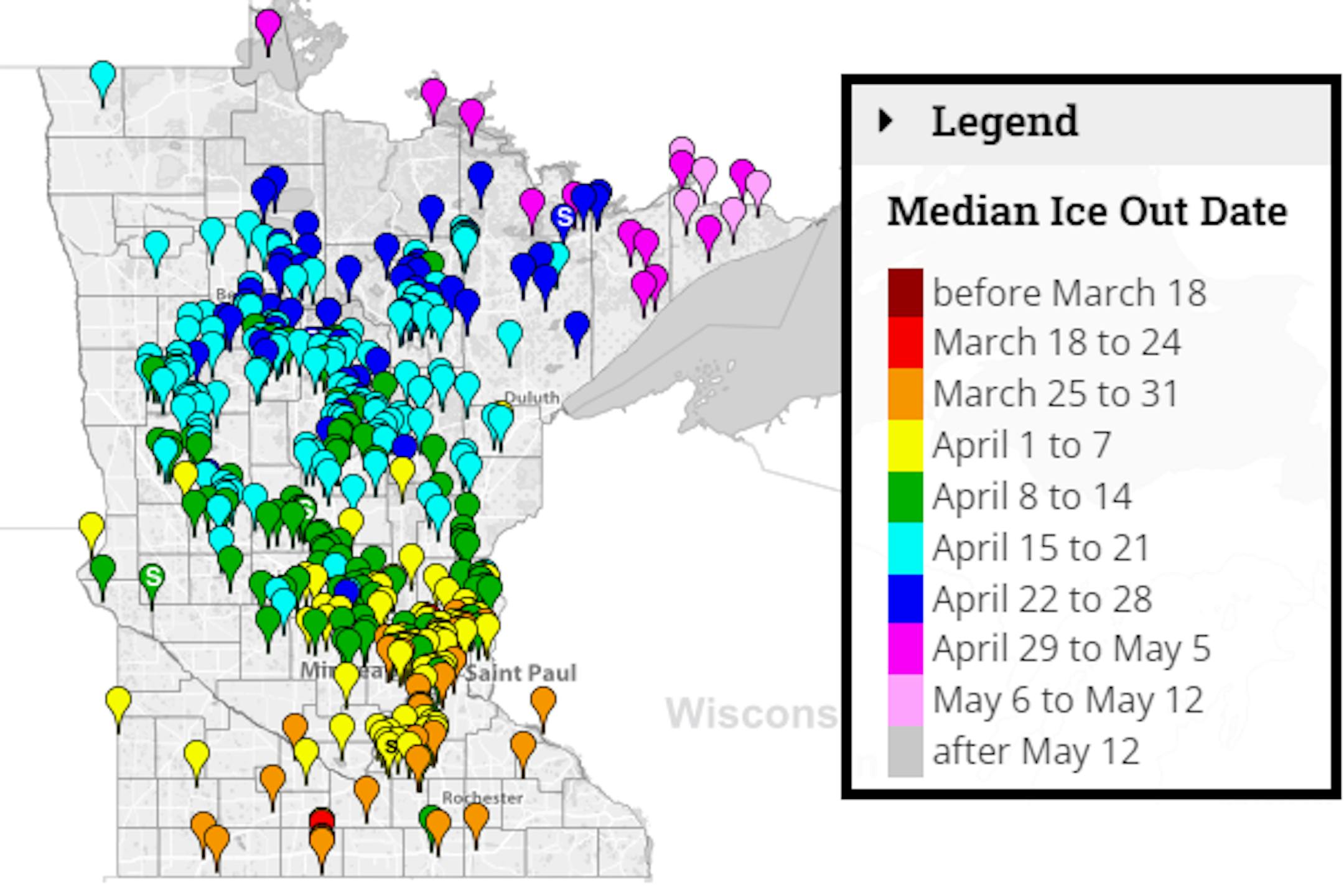
Average Ice Out Dates
We're still several weeks away from ice out across the state, but according to the MN DNR, here's a look at the average ice out dates for lakes across the state. Note that some lakes across the southern part of the state typically see ice out around the end of March. Lake Minnetonka typically doesn't see ice out until mid April. A few lakes in far northern & northeastern MN don't see ice out until late April or early May.
Great Lakes Ice Coverage
According to NOAA's GLERL, near 14% of the great lakes is considered ice covered. 22% of Lake Superior is ice covered.

Status of Spring
"March 21, 2022 - Spring leaf out continues to progress across the country. Our spring leaf anomaly compares the arrival of spring leaf out this year to a long-term average of 1991-2020. After a slow start to spring across much of the Southeast, spring is progressing more rapidly, arriving a few days to a week early in the southern Great Plains, the Southern Appalachians, and parts of Kentucky, Ohio, and West Virginia. The Washington, D.C. area is 5-10 days early. Parts of New York City are one week early. In western states, spring leaf out is patchy, arriving a week late in some locations and over a month early in others. Spring bloom has also started to arrive in southern states, days to a week late in Texas and Florida and days to several weeks early in California. Spring bloom is over a week early in parts of Georgia, South Carolina, and North Carolina. We will continue to update this page as spring leaf out and bloom unfold across the country - check back frequently on this page!"


